
Magnitude |
:2.6 |
| Date & Time (UTC) | 2005-11-22 05:11:38.9 |
| Date & Time (Local) | 1384/9/1 08:41:38.9 |
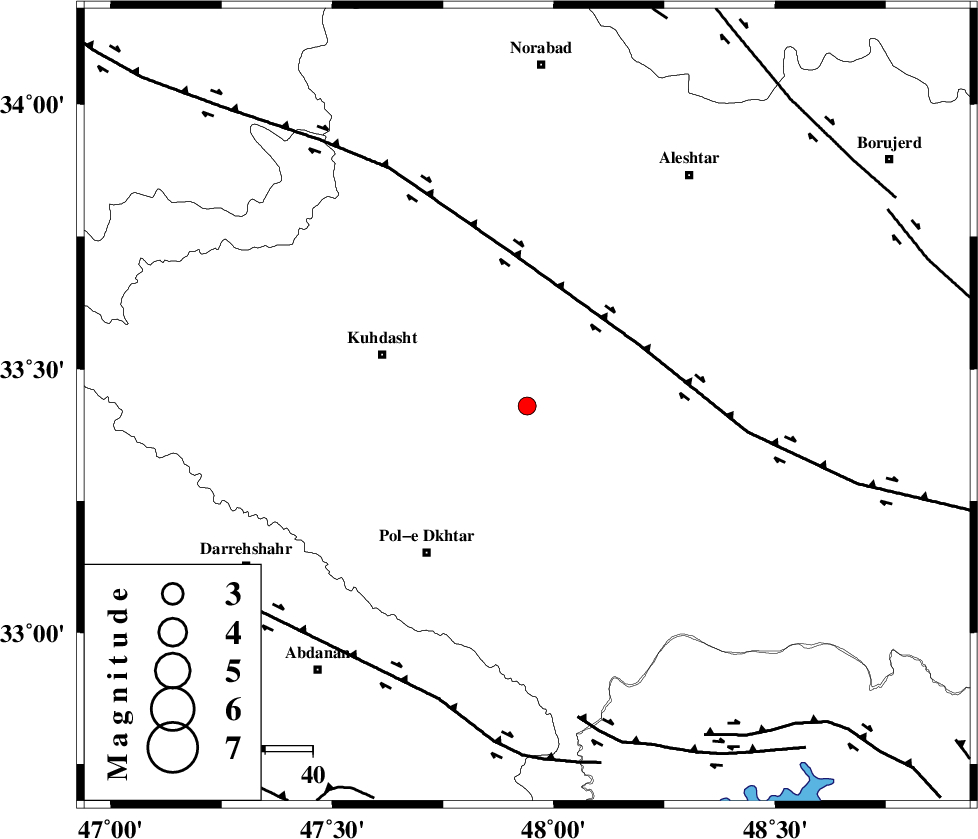
| Location | Lat:33.43 Lon: 47.94 |
| Region | |
Nearest Cities |
|
| 7 km North of Maeulan, Lorestan Province | |
| 11 km of Mahmudvand, Lorestan Province | |
| 17 km South West of Sarabboreh, Lorestan Province | |
| 19 km West of Godar-e mahmudvand, Lorestan Province | |
| 24 km North West of Shoorab-e sofla, Lorestan Province | |
| Depth | 18 km |
| Agency | |
Faults within 150 km: |
|
| HZF4 (Length: 492 km) , Distance to epicenter: 27 km | |
| BALARUD_F_Z1 (Length: 87 km) , Distance to epicenter: 65 km | |
| BALARUD_F_Z3 (Length: 53 km) , Distance to epicenter: 66 km | |
| Number of Phases | 6 |
| RMS | 0.1 |
| Number of Stations | 3 |
| Error in Latitude | >1 km |
| Error in Longitude | 2 km |
| Error in Depth | 14.8 km |
Download waveform in seisan format
to download seisan software Click here
to access information about IIEES stations Click here
Amplitude | ||||||||
| UID | Agency | Station | Component | Amplitude | Period | Arrival Time | Proccessing Time | Signal Clip |
| 10221 | IIEES | SNGE | N | 88.9 | 0.5 | 2005-11-22 05:12:42 | 2006-01-09 11:55:00 | n |
| 10222 | IIEES | ASAO | N | 31.7 | 0.54 | 2005-11-22 05:12:54 | 2006-01-09 11:55:00 | n |
Phase | ||||||||||||
| Agency | Station | Component | Phase Type | Phase Quality | First Motion | Observed Arrival Time | Time Residual | Loc. Flag | Input Weight | Distance | Azimuth | |
| IIEES | SHGR | Z | PG | E | 2005-11-22 05:12:06 | 0 | y | 167 | 151 | |||
| IIEES | SHGR | E | SG | E | 2005-11-22 05:12:27 | 0 | y | 167 | 151 | |||
| IIEES | SNGE | Z | PG | E | 2005-11-22 05:12:11 | 0.2 | y | 193 | 344 | |||
| IIEES | SNGE | N | SG | E | 2005-11-22 05:12:34 | -0.1 | y | 193 | 344 | |||
| IIEES | ASAO | Z | PG | E | 2005-11-22 05:12:16 | 0 | y | 229 | 57 | |||
| IIEES | ASAO | N | SG | E | 2005-11-22 05:12:44 | 0 | y | 229 | 57 | |||