
Magnitude |
:3.1 |
| Date & Time (UTC) | 2026-01-24 23:50:52.7 |
| Date & Time (Local) | 1404/11/5 03:20:52.7 |
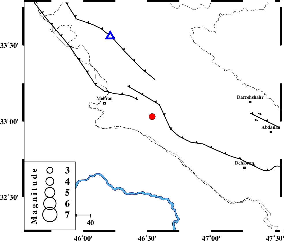
| Location | Lat:33.032 Lon: 46.538 |
| Region | Ilam Province, 36 km -East of Mehran |
Nearest Cities |
|
| 24 km South of Gonbad-e pirmohammad, Ilam Province | |
| 35 km South East of Galeh-yedarre-hemalakshahi, Ilam Province | |
| 36 km East of Mehran, Ilam Province | |
| 43 km South West of Meymeh, Ilam Province | |
| 46 km South of Mehr, Ilam Province | |
| Depth | 12 km |
| Agency | |
Faults within 150 km: |
|
| MFF6 (Length: 144 km) , Distance to epicenter: 9 km | |
| ZFF4 (Length: 128 km) , Distance to epicenter: 16 km | |
| MFF7 (Length: 99 km) , Distance to epicenter: 27 km | |
| Number of Phases | 9 |
| RMS | 0.2 |
| Number of Stations | 9 |
| Error in Latitude | >2.7 km |
| Error in Longitude | 2.7 km |
| Error in Depth | 279.3 km |
Download waveform in seisan format
to download seisan software Click here
to access information about IIEES stations Click here
Amplitude | ||||||||
| UID | Agency | Station | Component | Amplitude | Period | Arrival Time | Proccessing Time | Signal Clip |
| 201176 | IIEES SC | AMS1 | Z | 0.1 | 1 | 2026-01-24 23:51:36 | 2026-01-25 06:15:00 | n |
| 201177 | IIEES SC | ASAO | Z | 0.08 | 1 | 2026-01-24 23:51:46 | 2026-01-25 06:15:00 | n |
| 201178 | IIEES SC | SRSL | Z | 0.07 | 1 | 2026-01-24 23:51:46 | 2026-01-25 06:15:00 | n |
| 201179 | IIEES SC | SFB | Z | 0.01 | 1 | 2026-01-24 23:52:08 | 2026-01-25 06:15:00 | n |
| 201180 | IIEES SC | GRMI | Z | 0.01 | 1 | 2026-01-24 23:52:21 | 2026-01-25 06:15:00 | n |
Phase | ||||||||||||
| Agency | Station | Component | Phase Type | Phase Quality | First Motion | Observed Arrival Time | Time Residual | Loc. Flag | Input Weight | Distance | Azimuth | |
| IIEES SC | HNVD | Z | EPn | E | 2026-01-24 23:51:27 | 0.3 | y | 0 | 214 | 48 | ||
| IIEES SC | AMS1 | Z | EPn | E | 2026-01-24 23:51:36 | 0.1 | y | 0 | 288 | 112 | ||
| IIEES SC | ASAO | Z | EPn | E | 2026-01-24 23:51:46 | 0.4 | y | 0 | 364 | 63 | ||
| IIEES SC | SRSL | Z | EPn | E | 2026-01-24 23:51:46 | -0.1 | y | 0 | 367 | 344 | ||
| IIEES SC | GHVR | Z | EPn | E | 2026-01-24 23:51:58 | -0.1 | y | 0 | 465 | 70 | ||
| IIEES SC | CHTH | Z | EPn | E | 2026-01-24 23:52:05 | -0.7 | y | 0 | 529 | 53 | ||
| IIEES SC | SFB | Z | EPn | E | 2026-01-24 23:52:08 | -0.2 | y | 0 | 549 | 75 | ||
| IIEES SC | NASN | Z | EPn | E | 2026-01-24 23:52:13 | -0.3 | y | 0 | 587 | 93 | ||
| IIEES SC | GRMI | Z | EPn | E | 2026-01-24 23:52:21 | 0.1 | y | 0 | 652 | 11 | ||