
Magnitude |
:3 |
| Date & Time (UTC) | 2026-01-03 17:24:44.7 |
| Date & Time (Local) | 1404/10/13 20:54:44.7 |
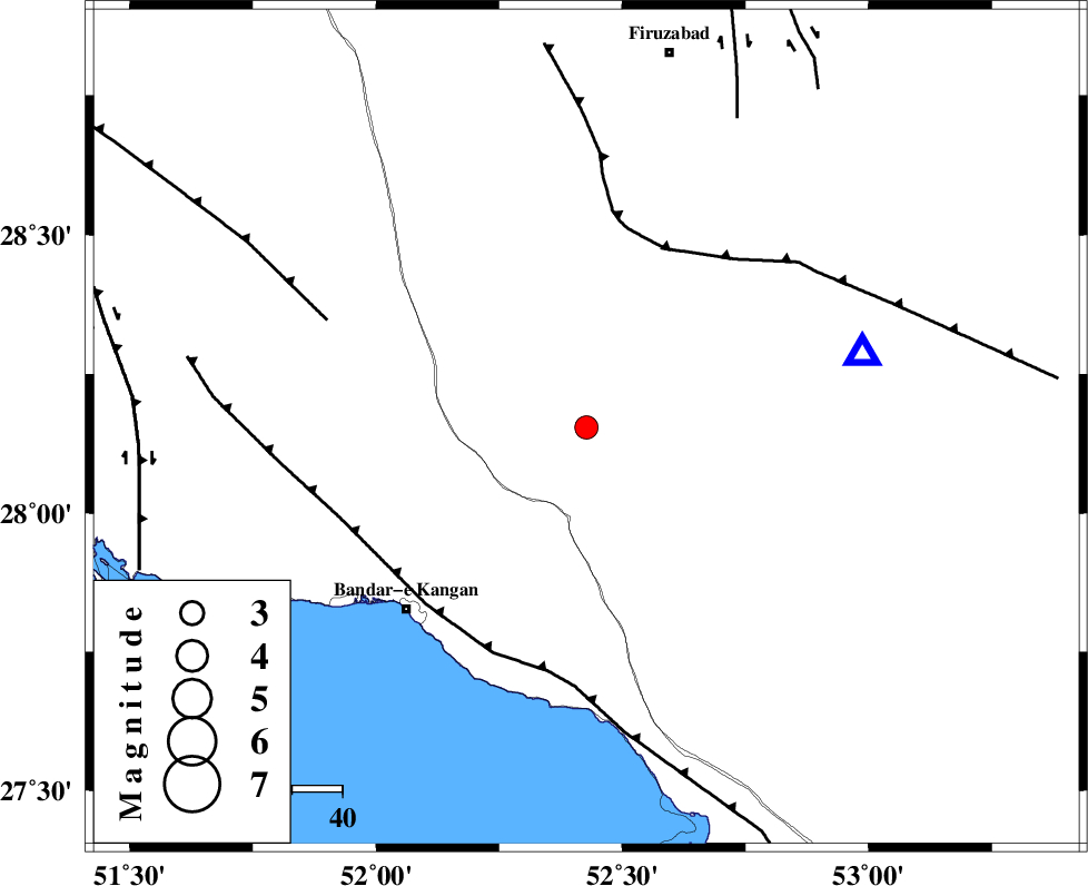
| Location | Lat:28.154 Lon: 52.427 |
| Region | Fars Province, 37 km North-East of Jam |
Nearest Cities |
|
| 13 km North East of Dolatabad, Fars Province | |
| 32 km South West of Hengam, Fars Province | |
| 34 km North West of Garmesht, Fars Province | |
| 37 km North East of Riz, Bushehr Province | |
| 37 km North East of Jam, Bushehr Province | |
| Depth | 12 km |
| Agency | |
Faults within 150 km: |
|
| QIR_F (Length: 130 km) , Distance to epicenter: 39 km | |
| MFF3 (Length: 292 km) , Distance to epicenter: 48 km | |
| MFF5 (Length: 74 km) , Distance to epicenter: 56 km | |
| Number of Phases | 7 |
| RMS | 0.3 |
| Number of Stations | 7 |
| Error in Latitude | >6.7 km |
| Error in Longitude | 6.7 km |
| Error in Depth | 607 km |
Download waveform in seisan format
to download seisan software Click here
to access information about IIEES stations Click here
Amplitude | ||||||||
| UID | Agency | Station | Component | Amplitude | Period | Arrival Time | Proccessing Time | Signal Clip |
| 200865 | IIEES SC | KRBR | Z | 0.03 | 1 | 2026-01-03 17:25:50 | 2026-01-04 08:58:00 | n |
| 200866 | IIEES SC | NASN | Z | 0.01 | 1 | 2026-01-03 17:25:56 | 2026-01-04 08:58:00 | n |
| 200867 | IIEES SC | UOSS | Z | 0.01 | 1 | 2026-01-03 17:25:56 | 2026-01-04 08:58:00 | n |
| 200868 | IIEES SC | IRSR | Z | 0.003 | 1 | 2026-01-03 17:26:37 | 2026-01-04 08:58:00 | n |
Phase | ||||||||||||
| Agency | Station | Component | Phase Type | Phase Quality | First Motion | Observed Arrival Time | Time Residual | Loc. Flag | Input Weight | Distance | Azimuth | |
| IIEES SC | GHIR | Z | EPg | E | 2026-01-03 17:24:56 | 1.3 | n | 4 | 57 | 75 | ||
| IIEES SC | KRBR | Z | EPn | E | 2026-01-03 17:25:50 | -0.4 | y | 0 | 468 | 64 | ||
| IIEES SC | YZKH | Z | EPn | E | 2026-01-03 17:25:57 | 0.6 | y | 0 | 514 | 24 | ||
| IIEES SC | NASN | Z | EPn | E | 2026-01-03 17:25:56 | -0.3 | y | 0 | 516 | 4 | ||
| IIEES SC | UOSS | Z | EPn | E | 2026-01-03 17:25:56 | -0.1 | y | 0 | 518 | 133 | ||
| IIEES SC | IRSR | Z | EPn | E | 2026-01-03 17:26:37 | 0.2 | y | 0 | 843 | 99 | ||
| IIEES SC | CHBR | Z | EPn | E | 2026-01-03 17:26:38 | 0.3 | y | 0 | 849 | 110 | ||