
Magnitude |
:3.1 |
| Date & Time (UTC) | 2025-11-14 02:31:41.6 |
| Date & Time (Local) | 1404/8/23 06:01:41.6 |
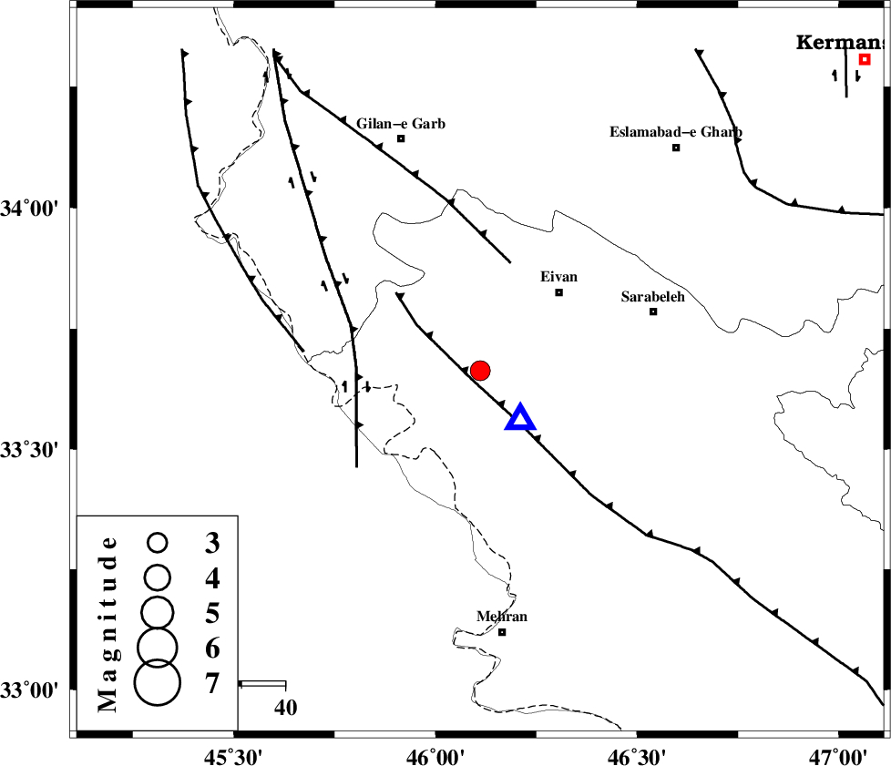
| Location | Lat:33.663 Lon: 46.111 |
| Region | Ilam Province, 30 km -West of Ilam |
Nearest Cities |
|
| 15 km West of Chavar, Ilam Province | |
| 22 km North of Salehabad, Ilam Province | |
| 26 km South West of Eyvan, Ilam Province | |
| 30 km North West of Ilam, Ilam Province | |
| 30 km South of Zarneh, Ilam Province | |
| Depth | 12 km |
| Agency | |
Faults within 150 km: |
|
| MFF7 (Length: 99 km) , Distance to epicenter: 4 km | |
| ZFF4 (Length: 128 km) , Distance to epicenter: 27 km | |
| MFF6 (Length: 144 km) , Distance to epicenter: 52 km | |
| Number of Phases | 5 |
| RMS | 0 |
| Number of Stations | 5 |
| Error in Latitude | >33.7 km |
| Error in Longitude | 46.1 km |
| Error in Depth | 12 km |
Download waveform in seisan format
to download seisan software Click here
to access information about IIEES stations Click here
Amplitude | ||||||||
| UID | Agency | Station | Component | Amplitude | Period | Arrival Time | Proccessing Time | Signal Clip |
| 200096 | IIEES SC | SRSL | Z | 0.2 | 1 | 2025-11-14 02:32:25 | 2025-11-15 07:07:00 | n |
| 200097 | IIEES SC | ASAO | Z | 0.05 | 1 | 2025-11-14 02:32:36 | 2025-11-15 07:07:00 | n |
Phase | ||||||||||||
| Agency | Station | Component | Phase Type | Phase Quality | First Motion | Observed Arrival Time | Time Residual | Loc. Flag | Input Weight | Distance | Azimuth | |
| IIEES SC | SRSL | Z | EPn | E | 2025-11-14 02:32:25 | 0 | y | 0 | 289 | 348 | ||
| IIEES SC | ASAO | Z | EPn | E | 2025-11-14 02:32:36 | -0.1 | y | 0 | 374 | 75 | ||
| IIEES SC | BSR2 | Z | EPn | E | 2025-11-14 02:32:39 | 0 | y | 0 | 400 | 159 | ||
| IIEES SC | GHVR | Z | EPn | E | 2025-11-14 02:32:49 | 0.1 | y | 0 | 482 | 79 | ||
| IIEES SC | GIDE | Z | EPn | E | 2025-11-14 02:32:59 | 8.6 | n | 4 | 495 | 43 | ||