
Magnitude |
:3 |
| Date & Time (UTC) | 2025-04-22 04:47:42.0 |
| Date & Time (Local) | 1404/2/2 08:17:42.0 |
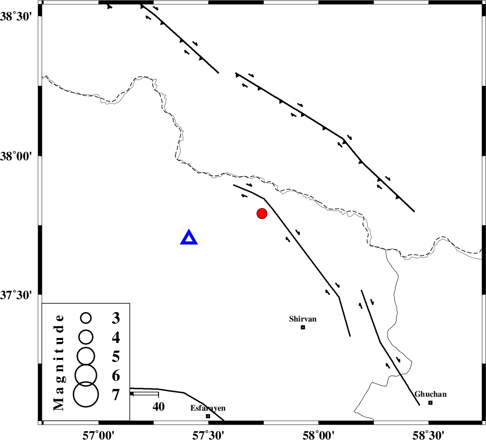
| Location | Lat:37.792 Lon: 57.742 |
| Region | Khorasan(north) Province, 48 km North-West of Shirvan |
Nearest Cities |
|
| 5 km North of Yangi ghale-ye bala, Khorasan(north) Province | |
| 18 km North of Tukur, Khorasan(north) Province | |
| 22 km North West of Kuseh, Khorasan(north) Province | |
| 23 km North West of Lojali, Khorasan(north) Province | |
| 25 km South East of Gifan olia, Khorasan(north) Province | |
| Depth | 12 km |
| Agency | |
Faults within 150 km: |
|
| BAGHAN_GERMAB_F (Length: 79 km) , Distance to epicenter: 5 km | |
| MAIN_KOPEHDAGH_F3 (Length: 96 km) , Distance to epicenter: 43 km | |
| GHUCHAN_F (Length: 50 km) , Distance to epicenter: 50 km | |
| Number of Phases | 8 |
| RMS | 0.3 |
| Number of Stations | 8 |
| Error in Latitude | >3.9 km |
| Error in Longitude | 3.9 km |
| Error in Depth | 2.2 km |
Download waveform in seisan format
to download seisan software Click here
to access information about IIEES stations Click here
Amplitude | ||||||||
| UID | Agency | Station | Component | Amplitude | Period | Arrival Time | Proccessing Time | Signal Clip |
| 197965 | IIEES SC | BJRD | Z | 7 | 1 | 2025-04-22 04:47:47 | 2025-04-22 07:32:00 | n |
| 197966 | IIEES SC | BJRD | Z | 7 | 1 | 2025-04-22 04:47:52 | 2025-04-22 07:32:00 | n |
| 197967 | IIEES SC | MRVT | Z | 0.8 | 1 | 2025-04-22 04:48:06 | 2025-04-22 07:32:00 | n |
Phase | ||||||||||||
| Agency | Station | Component | Phase Type | Phase Quality | First Motion | Observed Arrival Time | Time Residual | Loc. Flag | Input Weight | Distance | Azimuth | |
| IIEES SC | BJRD | Z | EPg | E | 2025-04-22 04:47:47 | -0.4 | y | 0 | 31 | 251 | ||
| IIEES SC | BJRD | Z | ESg | E | 2025-04-22 04:47:52 | -0.2 | y | 0 | 31 | 251 | ||
| IIEES SC | MRVT | Z | EPg | E | 2025-04-22 04:48:06 | 0 | y | 0 | 146 | 264 | ||
| IIEES SC | KAGH | Z | EPn | E | 2025-04-22 04:48:17 | 0 | y | 0 | 218 | 116 | ||
| IIEES SC | SHRO | Z | EPn | E | 2025-04-22 04:48:22 | 1.3 | y | 0 | 251 | 218 | ||
| IIEES SC | ABGH | Z | EPn | E | 2025-04-22 04:48:25 | 0.2 | y | 0 | 286 | 246 | ||
| IIEES SC | TABS | Z | EPn | E | 2025-04-22 04:48:17 | -30.3 | n | 4 | 463 | 187 | ||
| IIEES SC | GRMI | Z | EPn | E | 2025-04-22 04:49:26 | -11.2 | n | 4 | 869 | 277 | ||