
Magnitude |
:2.9 |
| Date & Time (UTC) | 2017-08-09 04:05:39.1 |
| Date & Time (Local) | 1396/5/18 08:35:39.1 |
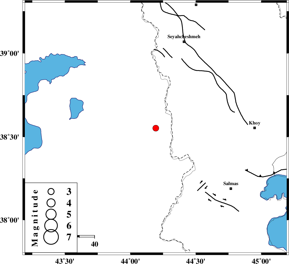
| Location | Lat:38.552 Lon: 44.194 |
| Region | Turkey, 60 km South-West of Seyah Cheshmah |
Nearest Cities |
|
| 21 km North West of Gatur, Azarbaijan Gharbi Province | |
| 27 km West of Baleh sur-e sofla, Azarbaijan Gharbi Province | |
| 43 km South West of Zarabad, Azarbaijan Gharbi Province | |
| 52 km North West of Kuzeh rash, Azarbaijan Gharbi Province | |
| 53 km North West of Beyk sofla, Azarbaijan Gharbi Province | |
| Depth | 14 km |
| Agency | |
Faults within 150 km: |
|
| KHOY (Length: 100 km) , Distance to epicenter: 47 km | |
| SALMAS (Length: 20 km) , Distance to epicenter: 49 km | |
| N_TABRIZ_F3 (Length: 66 km) , Distance to epicenter: 66 km | |
| Number of Phases | 6 |
| RMS | 0.2 |
| Number of Stations | 4 |
| Error in Latitude | >3.3 km |
| Error in Longitude | 4.7 km |
| Error in Depth | 8.3 km |
Download waveform in seisan format
to download seisan software Click here
to access information about IIEES stations Click here
Amplitude | ||||||||
| UID | Agency | Station | Component | Amplitude | Period | Arrival Time | Proccessing Time | Signal Clip |
| 118774 | IIEES | MAKU | N | 480 | 0.28 | 2017-08-09 04:06:12 | 2017-08-22 05:19:00 | n |
| 118775 | IIEES | MAKU | E | 423.4 | 0.56 | 2017-08-09 04:06:14 | 2017-08-22 05:19:00 | n |
| 118776 | IIEES | GRMI | E | 18.5 | 0.84 | 2017-08-09 04:07:20 | 2017-08-22 05:19:00 | n |
Phase | ||||||||||||
| Agency | Station | Component | Phase Type | Phase Quality | First Motion | Observed Arrival Time | Time Residual | Loc. Flag | Input Weight | Distance | Azimuth | |
| IIEES | MAKU | Z | Pg | E | 2017-08-09 04:05:55 | -0.19 | y | 98.8 | 25 | |||
| IIEES | MAKU | N | Sg | E | 2017-08-09 04:06:08 | 0.1 | y | 98.8 | 25 | |||
| IIEES | GRMI | Z | Pn | E | 2017-08-09 04:06:27 | 0.15 | y | 323 | 84 | |||
| IIEES | GRMI | N | Sg | E | 2017-08-09 04:07:09 | -0.1 | y | 323 | 84 | |||
| IIEES | ZNJK | Z | Pn | E | 2017-08-09 04:06:42 | 0.2 | y | 448 | 116 | |||
| IIEES | SNGE | Z | Pn | E | 2017-08-09 04:06:45 | -0.15 | y | 476 | 143 | |||