
Magnitude |
:1.9 |
| Date & Time (UTC) | 2015-10-17 23:51:58.4 |
| Date & Time (Local) | 1394/7/26 03:21:58.4 |
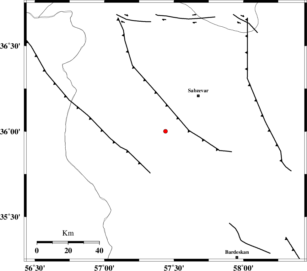
| Location | Lat:36.001 Lon: 57.439 |
| Region | Khorasan(center) Province, 31 km South-West of Sabzevar |
Nearest Cities |
|
| 27 km North West of Bejdan, Khorasan(center) Province | |
| 27 km South East of Rivand, Khorasan(center) Province | |
| 30 km North West of Sheshtamad, Khorasan(center) Province | |
| 31 km South West of Sabzevar, Khorasan(center) Province | |
| 37 km North West of Tondak, Khorasan(center) Province | |
| Depth | 14 km |
| Agency | |
Faults within 150 km: |
|
| SABZEVAR_F (Length: 81 km) , Distance to epicenter: 29 km | |
| BALHAR_F (Length: 117 km) , Distance to epicenter: 61 km | |
| JOGHATAI_F (Length: 70 km) , Distance to epicenter: 75 km | |
| Number of Phases | 5 |
| RMS | 0.3 |
| Number of Stations | 3 |
| Error in Latitude | >7.2 km |
| Error in Longitude | 8.9 km |
| Error in Depth | 9.9 km |
Download waveform in seisan format
to download seisan software Click here
to access information about IIEES stations Click here
Amplitude | ||||||||
| UID | Agency | Station | Component | Amplitude | Period | Arrival Time | Proccessing Time | Signal Clip |
| 101832 | IIEES | SHRO | N | 20.7 | 0.22 | 2015-10-17 23:52:39 | 2015-10-18 08:02:00 | n |
| 101833 | IIEES | SHRO | E | 17.9 | 0.2 | 2015-10-17 23:52:41 | 2015-10-18 08:02:00 | n |
| 101834 | IIEES | MRVT | N | 11.9 | 0.45 | 2015-10-17 23:53:02 | 2015-10-18 08:02:00 | n |
| 101835 | IIEES | MRVT | E | 13.3 | 0.53 | 2015-10-17 23:53:02 | 2015-10-18 08:02:00 | n |
Phase | ||||||||||||
| Agency | Station | Component | Phase Type | Phase Quality | First Motion | Observed Arrival Time | Time Residual | Loc. Flag | Input Weight | Distance | Azimuth | |
| IIEES | SHRO | Z | Pg | E | 2015-10-17 23:52:20 | 0.37 | y | 129 | 271 | |||
| IIEES | SHRO | N | Sg | E | 2015-10-17 23:52:35 | -0.24 | y | 129 | 271 | |||
| IIEES | BJRD | Z | Pg | E | 2015-10-17 23:52:29 | -0.47 | y | 189 | 359 | |||
| IIEES | BJRD | E | Sg | E | 2015-10-17 23:52:52 | 0.23 | y | 189 | 359 | |||
| IIEES | MRVT | Z | Pn | E | 2015-10-17 23:52:33 | 0.11 | y | 220 | 327 | |||