
Magnitude |
:2.6 |
| Date & Time (UTC) | 2015-10-12 22:10:22.9 |
| Date & Time (Local) | 1394/7/21 01:40:22.9 |
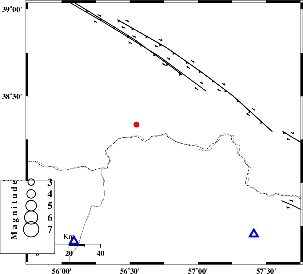
| Location | Lat:38.287 Lon: 56.753 |
| Region | Turkmenistan, 84 km North-West of Ashkhaneh |
Nearest Cities |
|
| 12 km North of Yekehsoud-e paeen, Khorasan(north) Province | |
| 41 km North West of Tangehzar, Khorasan(north) Province | |
| 51 km North West of Raz, Khorasan(north) Province | |
| 60 km North East of Qazanqayeh, Golestan Province | |
| 71 km North East of Garmab, Khorasan(north) Province | |
| Depth | 6 km |
| Agency | |
Faults within 150 km: |
|
| MAIN_KOPEHDAGH_F1 (Length: 318 km) , Distance to epicenter: 38 km | |
| MAIN_KOPEHDAGH_F2 (Length: 131 km) , Distance to epicenter: 46 km | |
| MAIN_KOPEHDAGH_F3 (Length: 96 km) , Distance to epicenter: 76 km | |
| Number of Phases | 4 |
| RMS | 0.1 |
| Number of Stations | 3 |
| Error in Latitude | >7.5 km |
| Error in Longitude | 3.2 km |
| Error in Depth | 4.5 km |
Download waveform in seisan format
to download seisan software Click here
to access information about IIEES stations Click here
Amplitude | ||||||||
| UID | Agency | Station | Component | Amplitude | Period | Arrival Time | Proccessing Time | Signal Clip |
| 101688 | IIEES | MRVT | E | 283.9 | 0.28 | 2015-10-12 22:10:57 | 2015-10-13 07:07:00 | n |
| 101689 | IIEES | MRVT | N | 264.8 | 0.21 | 2015-10-12 22:10:58 | 2015-10-13 07:07:00 | n |
| 101690 | IIEES | SHRO | E | 16.3 | 0.6 | 2015-10-12 22:11:48 | 2015-10-13 07:07:00 | n |
Phase | ||||||||||||
| Agency | Station | Component | Phase Type | Phase Quality | First Motion | Observed Arrival Time | Time Residual | Loc. Flag | Input Weight | Distance | Azimuth | |
| IIEES | BJRD | Z | Pg | E | 2015-10-12 22:10:38 | -0.07 | y | 86.9 | 138 | |||
| IIEES | BJRD | E | Sg | E | 2015-10-12 22:10:49 | 0.01 | y | 86.9 | 138 | |||
| IIEES | MRVT | Z | Pg | E | 2015-10-12 22:10:38 | -0.09 | y | 90.8 | 220 | |||
| IIEES | SHRO | Z | Pn | E | 2015-10-12 22:11:04 | 0.15 | y | 261 | 195 | |||