
Magnitude |
:1.9 |
| Date & Time (UTC) | 2015-10-02 09:04:58.0 |
| Date & Time (Local) | 1394/7/10 12:34:58.0 |
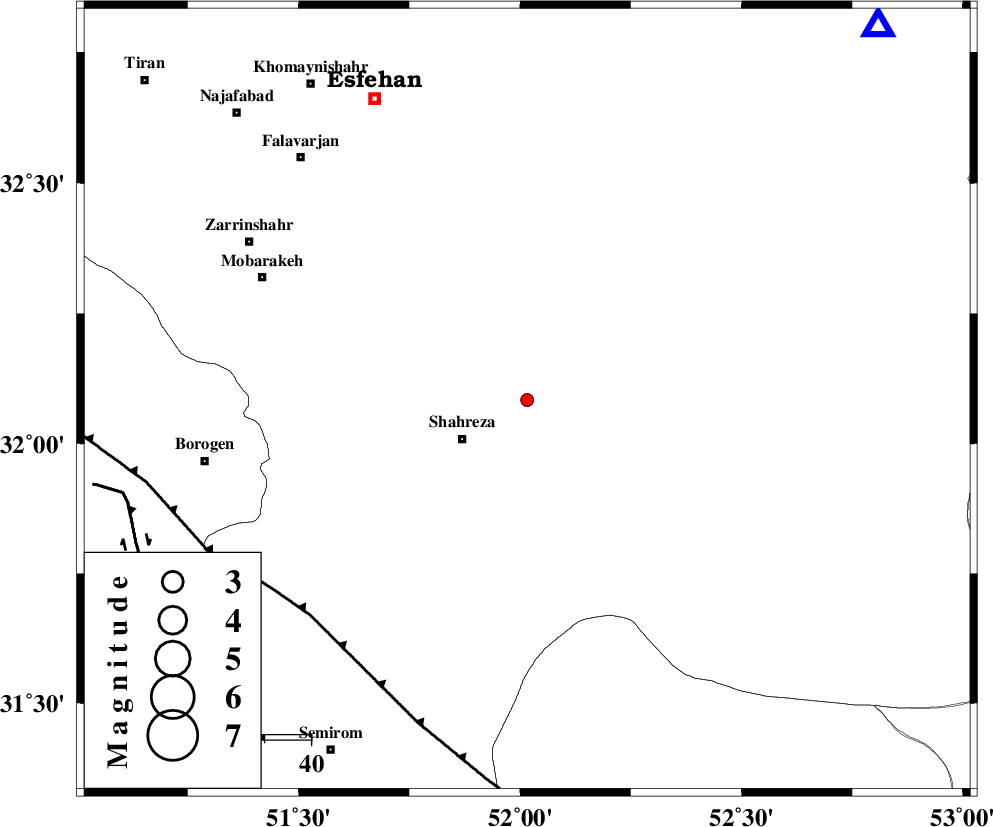
| Location | Lat:32.084 Lon: 52.016 |
| Region | Esfahan Province, 16 km -East of Shahreza |
Nearest Cities |
|
| 16 km North East of Shahreza, Esfahan Province | |
| 27 km South of Mohammadabad, Esfahan Province | |
| 29 km South East of Mahyar, Esfahan Province | |
| 30 km South West of Nikabad, Esfahan Province | |
| 32 km North East of Musaabad, Esfahan Province | |
| Depth | 14 km |
| Agency | |
Faults within 150 km: |
|
| MAIN_ZAGROS_R_F (Length: 1106 km) , Distance to epicenter: 65 km | |
| DENA_F (Length: 137 km) , Distance to epicenter: 88 km | |
| DOPOLAN_F (Length: 107 km) , Distance to epicenter: 92 km | |
| Number of Phases | 5 |
| RMS | 0.2 |
| Number of Stations | 3 |
| Error in Latitude | >5.3 km |
| Error in Longitude | 4.1 km |
| Error in Depth | 9.9 km |
Download waveform in seisan format
to download seisan software Click here
to access information about IIEES stations Click here
Amplitude | ||||||||
| UID | Agency | Station | Component | Amplitude | Period | Arrival Time | Proccessing Time | Signal Clip |
| 101448 | IIEES | NASN | E | 45.6 | 0.28 | 2015-10-02 09:05:35 | 2015-10-05 08:54:00 | n |
| 101449 | IIEES | NASN | N | 27.8 | 0.36 | 2015-10-02 09:05:38 | 2015-10-05 08:54:00 | n |
Phase | ||||||||||||
| Agency | Station | Component | Phase Type | Phase Quality | First Motion | Observed Arrival Time | Time Residual | Loc. Flag | Input Weight | Distance | Azimuth | |
| IIEES | NASN | Z | Pg | E | 2015-10-02 09:05:16 | -0.34 | y | 109 | 43 | |||
| IIEES | NASN | N | Sg | E | 2015-10-02 09:05:30 | 0.15 | y | 109 | 43 | |||
| IIEES | YZKH | Z | P | E | 2015-10-02 09:05:36 | 0.11 | y | 245 | 81 | |||
| IIEES | YZKH | N | Sg | E | 2015-10-02 09:06:07 | 0.01 | y | 245 | 81 | |||
| IIEES | KHMZ | Z | Pn | E | 2015-10-02 09:05:38 | 0.08 | y | 266 | 314 | |||