
Magnitude |
:2.6 |
| Date & Time (UTC) | 2015-09-17 19:50:29.6 |
| Date & Time (Local) | 1394/6/27 00:20:29.6 |
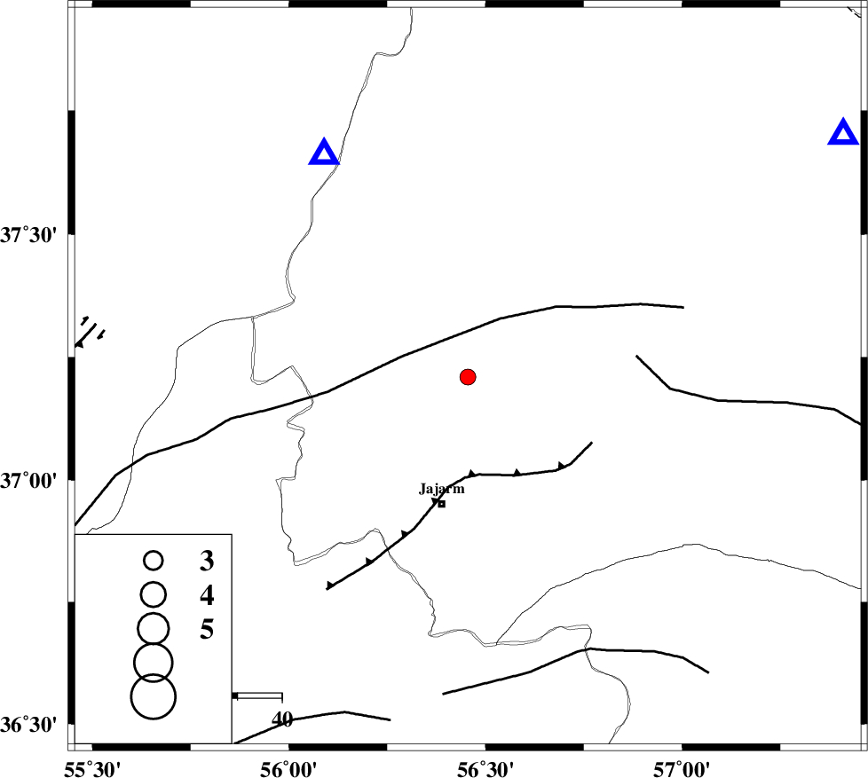
| Location | Lat:37.209 Lon: 56.455 |
| Region | Khorasan(north) Province, 29 km North of Jajarm |
Nearest Cities |
|
| 29 km North East of Garmeh, Khorasan(north) Province | |
| 29 km North of Jajarm, Khorasan(north) Province | |
| 38 km South West of Shogan, Khorasan(north) Province | |
| 56 km North West of Farashiyan, Khorasan(center) Province | |
| 57 km South West of Ashkhaneh, Khorasan(north) Province | |
| Depth | 14 km |
| Agency | |
Faults within 150 km: |
|
| ROBATE_QARABIL_F (Length: 168 km) , Distance to epicenter: 15 km | |
| JAJARAM_F (Length: 77 km) , Distance to epicenter: 22 km | |
| ESFARAYEN_F (Length: 111 km) , Distance to epicenter: 38 km | |
| Number of Phases | 4 |
| RMS | 0.1 |
| Number of Stations | 4 |
| Error in Latitude | >1.8 km |
| Error in Longitude | 6.3 km |
| Error in Depth | 5.9 km |
Download waveform in seisan format
to download seisan software Click here
to access information about IIEES stations Click here
Amplitude | ||||||||
| UID | Agency | Station | Component | Amplitude | Period | Arrival Time | Proccessing Time | Signal Clip |
| 101307 | IIEES | MRVT | N | 664.6 | 0.31 | 2015-09-17 19:50:52 | 2015-09-30 11:06:00 | n |
| 101308 | IIEES | SHRO | N | 53.2 | 0.32 | 2015-09-17 19:51:16 | 2015-09-30 11:06:00 | n |
Phase | ||||||||||||
| Agency | Station | Component | Phase Type | Phase Quality | First Motion | Observed Arrival Time | Time Residual | Loc. Flag | Input Weight | Distance | Azimuth | |
| IIEES | MRVT | Z | Pg | E | 2015-09-17 19:50:40 | 0 | y | 59.5 | 327 | |||
| IIEES | SHRO | Z | Pg | E | 2015-09-17 19:50:52 | -0.04 | y | 139 | 197 | |||
| IIEES | SHRT | Z | Pn | E | 2015-09-17 19:51:42 | -0.03 | y | 527 | 137 | |||
| IIEES | YZKH | Z | Pn | E | 2015-09-17 19:51:47 | 0.1 | y | 561 | 198 | |||