
Magnitude |
:1.9 |
| Date & Time (UTC) | 2015-09-17 09:04:26.1 |
| Date & Time (Local) | 1394/6/26 13:34:26.1 |
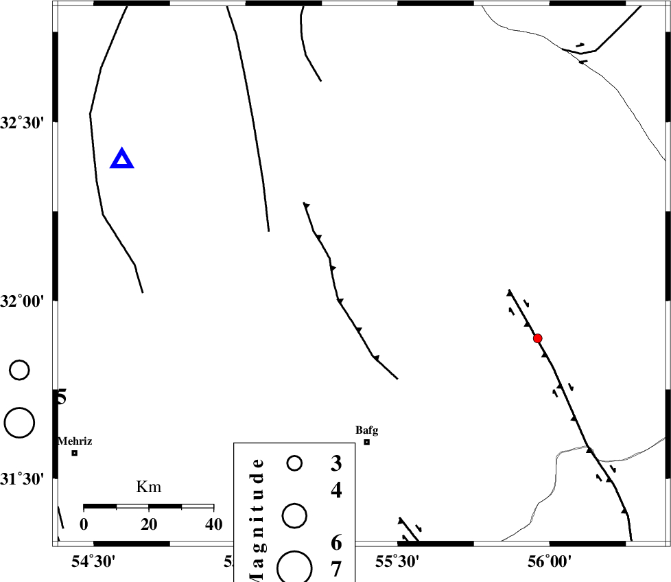
| Location | Lat:32.073 Lon: 55.381 |
| Region | Yazd Province, 52 km North of Bafq |
Nearest Cities |
|
| 50 km North of Mobarake, Yazd Province | |
| 52 km North of Bafq, Yazd Province | |
| 53 km North West of Kushk, Yazd Province | |
| 65 km North West of Behabad, Yazd Province | |
| 74 km South East of Kharaneq, Yazd Province | |
| Depth | 14 km |
| Agency | |
Faults within 150 km: |
|
| POSHT_E_BADAM_F (Length: 128 km) , Distance to epicenter: 5 km | |
| ANAR_F (Length: 91 km) , Distance to epicenter: 43 km | |
| SARBALA_F (Length: 92 km) , Distance to epicenter: 43 km | |
| Number of Phases | 4 |
| RMS | 0 |
| Number of Stations | 3 |
| Error in Latitude | >7.2 km |
| Error in Longitude | 2.7 km |
| Error in Depth | 6.2 km |
Download waveform in seisan format
to download seisan software Click here
to access information about IIEES stations Click here
Amplitude | ||||||||
| UID | Agency | Station | Component | Amplitude | Period | Arrival Time | Proccessing Time | Signal Clip |
| 101071 | IIEES | YZKH | E | 53.1 | 0.28 | 2015-09-17 09:04:54 | 2015-09-21 09:32:00 | n |
| 101072 | IIEES | YZKH | N | 47.4 | 0.31 | 2015-09-17 09:04:55 | 2015-09-21 09:32:00 | n |
Phase | ||||||||||||
| Agency | Station | Component | Phase Type | Phase Quality | First Motion | Observed Arrival Time | Time Residual | Loc. Flag | Input Weight | Distance | Azimuth | |
| IIEES | YZKH | Z | Pg | E | 2015-09-17 09:04:40 | -0.06 | y | 82.3 | 295 | |||
| IIEES | YZKH | E | Sg | E | 2015-09-17 09:04:50 | 0.02 | y | 82.3 | 295 | |||
| IIEES | TABS | Z | Pn | E | 2015-09-17 09:05:03 | 0 | y | 239 | 42 | |||
| IIEES | NASN | Z | Pn | E | 2015-09-17 09:05:05 | 0.04 | y | 255 | 289 | |||