
Magnitude |
:2 |
| Date & Time (UTC) | 2015-09-19 09:57:59.0 |
| Date & Time (Local) | 1394/6/28 14:27:59.0 |
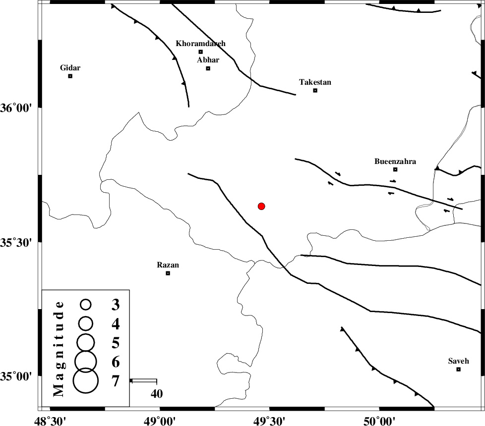
| Location | Lat:35.633 Lon: 49.462 |
| Region | Ghazvin Province, 47 km North-East of Razan |
Nearest Cities |
|
| 2 km North of Kolanjin, Ghazvin Province | |
| 21 km South East of Ab-e garm, Ghazvin Province | |
| 21 km North East of Avaj, Ghazvin Province | |
| 24 km South of Hoseynabad, Ghazvin Province | |
| 30 km South West of Danesfahan, Ghazvin Province | |
| Depth | 17 km |
| Agency | |
Faults within 150 km: |
|
| KUSHK_E_NOSRAT_F (Length: 230 km) , Distance to epicenter: 9 km | |
| IPAK_F (Length: 80 km) , Distance to epicenter: 24 km | |
| S_PARANDAK_F (Length: 116 km) , Distance to epicenter: 26 km | |
| Number of Phases | 5 |
| RMS | 0.3 |
| Number of Stations | 4 |
| Error in Latitude | >3.9 km |
| Error in Longitude | 5.8 km |
| Error in Depth | 8.9 km |
Download waveform in seisan format
to download seisan software Click here
to access information about IIEES stations Click here
Amplitude | ||||||||
| UID | Agency | Station | Component | Amplitude | Period | Arrival Time | Proccessing Time | Signal Clip |
| 101023 | IIEES | ASAO | E | 51.8 | 0.24 | 2015-09-19 09:58:39 | 2015-09-20 10:27:00 | n |
| 101024 | IIEES | ASAO | N | 40.1 | 0.38 | 2015-09-19 09:58:41 | 2015-09-20 10:27:00 | n |
| 101025 | IIEES | GHVR | E | 6.9 | 0.41 | 2015-09-19 09:59:06 | 2015-09-20 10:27:00 | n |
Phase | ||||||||||||
| Agency | Station | Component | Phase Type | Phase Quality | First Motion | Observed Arrival Time | Time Residual | Loc. Flag | Input Weight | Distance | Azimuth | |
| IIEES | ASAO | Z | Pg | E | 2015-09-19 09:58:21 | 0.11 | y | 131 | 157 | |||
| IIEES | ZNJK | Z | Pg | E | 2015-09-19 09:58:21 | -0.5 | y | 135 | 329 | |||
| IIEES | ZNJK | E | Sg | E | 2015-09-19 09:58:38 | 0.36 | y | 135 | 329 | |||
| IIEES | CHTH | Z | Pg | E | 2015-09-19 09:58:24 | 0.01 | y | 154 | 78 | |||
| IIEES | GHVR | Z | Pn | E | 2015-09-19 09:58:32 | 0.01 | y | 207 | 128 | |||