
Magnitude |
:2.8 |
| Date & Time (UTC) | 2015-08-29 21:55:25.9 |
| Date & Time (Local) | 1394/6/8 02:25:25.9 |
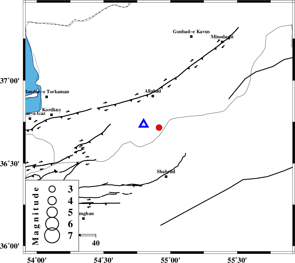
| Location | Lat:36.716 Lon: 54.914 |
| Region | Golestan Province, 21 km South of Ali Abad |
Nearest Cities |
|
| 19 km North West of Qaleh-ye nokharqan, Semnan Province | |
| 21 km South of Ali Abad, Golestan Province | |
| 27 km North of Bastam, Semnan Province | |
| 33 km North of Shahrud, Semnan Province | |
| 34 km South of Khanbebin, Golestan Province | |
| Depth | 14 km |
| Agency | |
Faults within 150 km: |
|
| SHAVAR_F (Length: 87 km) , Distance to epicenter: 14 km | |
| KHAZAR_F (Length: 523 km) , Distance to epicenter: 33 km | |
| ASTANEH_F (Length: 72 km) , Distance to epicenter: 38 km | |
| Number of Phases | 4 |
| RMS | 0 |
| Number of Stations | 3 |
| Error in Latitude | >2 km |
| Error in Longitude | 8.5 km |
| Error in Depth | 4.4 km |
Download waveform in seisan format
to download seisan software Click here
to access information about IIEES stations Click here
Amplitude | ||||||||
| UID | Agency | Station | Component | Amplitude | Period | Arrival Time | Proccessing Time | Signal Clip |
| 100581 | IIEES | SHRO | E | 277.3 | 0.32 | 2015-08-29 21:56:11 | 2015-08-30 07:50:00 | n |
| 100582 | IIEES | MRVT | E | 74 | 0.37 | 2015-08-29 21:56:17 | 2015-08-30 07:50:00 | n |
| 100583 | IIEES | BJRD | E | 78.8 | 0.45 | 2015-08-29 21:56:59 | 2015-08-30 07:50:00 | n |
Phase | ||||||||||||
| Agency | Station | Component | Phase Type | Phase Quality | First Motion | Observed Arrival Time | Time Residual | Loc. Flag | Input Weight | Distance | Azimuth | |
| IIEES | SHRO | Z | Pg | E | 2015-08-29 21:55:47 | 0 | y | 126 | 128 | |||
| IIEES | MRVT | Z | Pg | E | 2015-08-29 21:55:50 | -0.01 | y | 148 | 45 | |||
| IIEES | MRVT | N | Sg | E | 2015-08-29 21:56:08 | 0 | y | 148 | 45 | |||
| IIEES | BJRD | Z | Pn | E | 2015-08-29 21:56:04 | 0.01 | y | 247 | 63 | |||