
Magnitude |
:3.1 |
| Date & Time (UTC) | 2015-08-29 08:52:51.7 |
| Date & Time (Local) | 1394/6/7 13:22:51.7 |
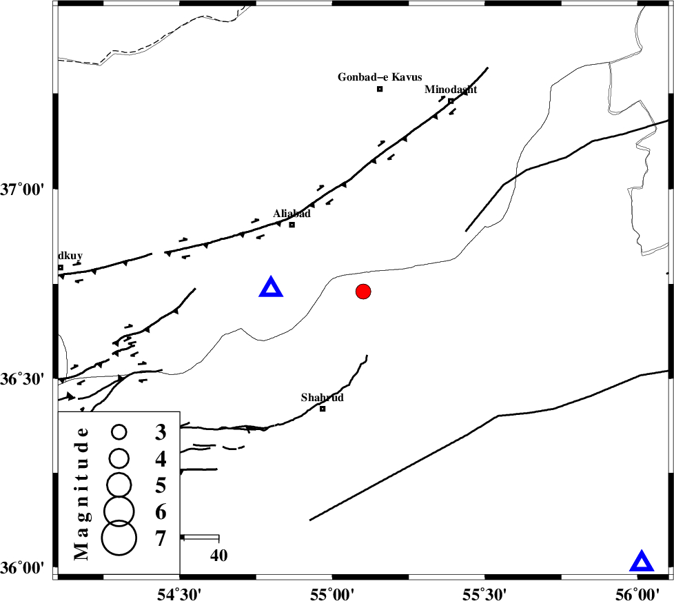
| Location | Lat:36.73 Lon: 55.101 |
| Region | Semnan Province, 32 km South of Ramian |
Nearest Cities |
|
| 11 km North of Qaleh-ye nokharqan, Semnan Province | |
| 20 km North West of Kalateh khanj, Semnan Province | |
| 28 km South East of Ali Abad, Golestan Province | |
| 29 km North of Bastam, Semnan Province | |
| 32 km South of Ramian, Golestan Province | |
| Depth | 15 km |
| Agency | |
Faults within 150 km: |
|
| SHAVAR_F (Length: 87 km) , Distance to epicenter: 4 km | |
| KHAZAR_F (Length: 523 km) , Distance to epicenter: 33 km | |
| ROBATE_QARABIL_F (Length: 168 km) , Distance to epicenter: 35 km | |
| Number of Phases | 6 |
| RMS | 0.3 |
| Number of Stations | 7 |
| Error in Latitude | >4.1 km |
| Error in Longitude | 5.6 km |
| Error in Depth | 7.2 km |
Download waveform in seisan format
to download seisan software Click here
to access information about IIEES stations Click here
Amplitude | ||||||||
| UID | Agency | Station | Component | Amplitude | Period | Arrival Time | Proccessing Time | Signal Clip |
| 100559 | IIEES | THKV | N | 38.7 | 0.52 | 2015-08-29 08:54:42 | 2015-08-29 10:44:00 | n |
Phase | ||||||||||||
| Agency | Station | Component | Phase Type | Phase Quality | First Motion | Observed Arrival Time | Time Residual | Loc. Flag | Input Weight | Distance | Azimuth | |
| IIEES | SHRO | Z | Pg | E | 2015-08-29 08:53:10 | -0.11 | y | 114 | 134 | |||
| IIEES | MRVT | Z | Pg | E | 2015-08-29 08:53:13 | -0.45 | y | 135 | 40 | |||
| IIEES | BJRD | Z | Pn | E | 2015-08-29 08:53:28 | 0.62 | y | 231 | 62 | |||
| IIEES | DAMV | Z | Pn | E | 2015-08-29 08:53:37 | 0.08 | y | 307 | 247 | |||
| IIEES | CHTH | Z | Pn | E | 2015-08-29 08:53:45 | -0.06 | y | 368 | 257 | |||
| IIEES | BSRN | Z | Pn | E | 2015-08-29 08:54:19 | -0.17 | y | 645 | 144 | |||