
Magnitude |
:2.8 |
| Date & Time (UTC) | 2015-08-25 16:16:01.3 |
| Date & Time (Local) | 1394/6/3 20:46:01.3 |
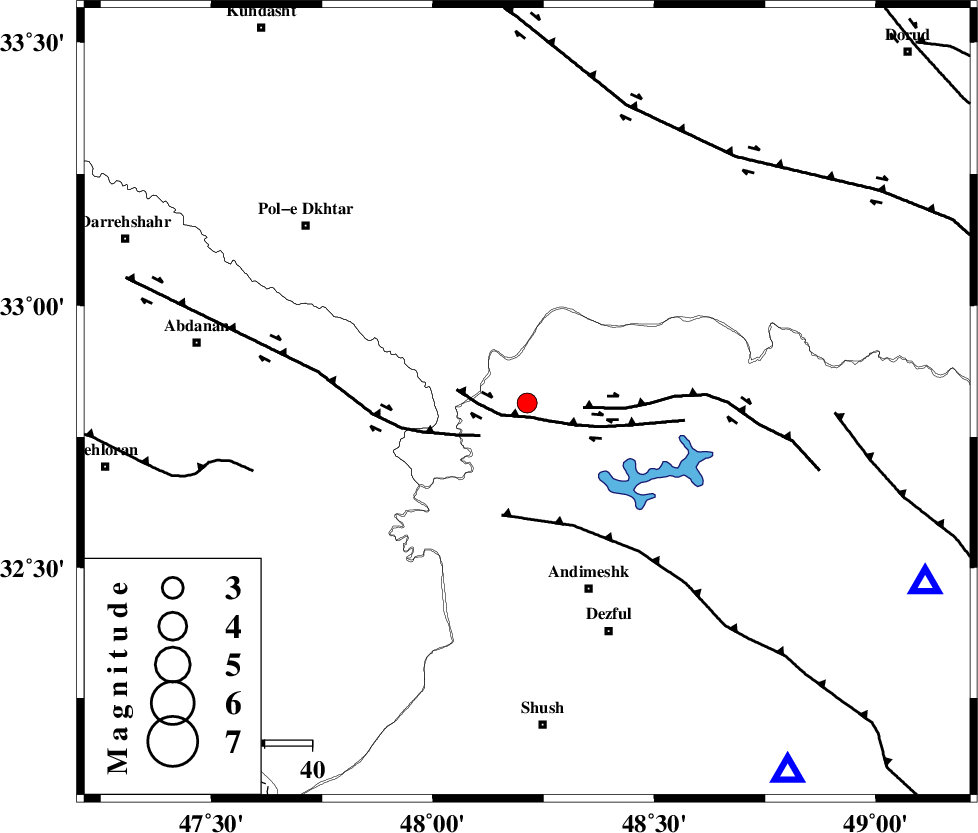
| Location | Lat:32.815 Lon: 48.213 |
| Region | Khoozestan Province, 42 km North-West of Andimeshk |
Nearest Cities |
|
| 7 km North of Bidruyeh, Khoozestan Province | |
| 12 km North West of Sorkhakan, Khoozestan Province | |
| 15 km North of Hoseinieh, Khoozestan Province | |
| 42 km North West of Andimeshk, Khoozestan Province | |
| 51 km North West of Dezful, Khoozestan Province | |
| Depth | 37 km |
| Agency | |
Faults within 150 km: |
|
| BALARUD_F_Z3 (Length: 53 km) , Distance to epicenter: 3 km | |
| BALARUD_F_Z2 (Length: 58 km) , Distance to epicenter: 12 km | |
| BALARUD_F_Z1 (Length: 87 km) , Distance to epicenter: 12 km | |
| Number of Phases | 8 |
| RMS | 0.3 |
| Number of Stations | 6 |
| Error in Latitude | >5.8 km |
| Error in Longitude | 5.2 km |
| Error in Depth | 9.4 km |
Download waveform in seisan format
to download seisan software Click here
to access information about IIEES stations Click here
Amplitude | ||||||||
| UID | Agency | Station | Component | Amplitude | Period | Arrival Time | Proccessing Time | Signal Clip |
| 100510 | IIEES | GHVR | N | 34.9 | 0.54 | 2015-08-25 16:17:34 | 2015-08-26 07:17:00 | n |
| 100511 | IIEES | GHVR | E | 24.8 | 0.54 | 2015-08-25 16:17:34 | 2015-08-26 07:17:00 | n |
Phase | ||||||||||||
| Agency | Station | Component | Phase Type | Phase Quality | First Motion | Observed Arrival Time | Time Residual | Loc. Flag | Input Weight | Distance | Azimuth | |
| IIEES | KHMZ | Z | Pg | E | 2015-08-25 16:16:33 | 0.5 | y | 193 | 57 | |||
| IIEES | SNGE | Z | Pn | E | 2015-08-25 16:16:40 | 0.19 | y | 265 | 343 | |||
| IIEES | SNGE | N | Sg | E | 2015-08-25 16:17:14 | -0.29 | y | 265 | 343 | |||
| IIEES | GHVR | Z | Pn | E | 2015-08-25 16:16:49 | 0.43 | y | 336 | 56 | |||
| IIEES | GHVR | N | Sg | E | 2015-08-25 16:17:33 | -0.31 | y | 336 | 56 | |||
| IIEES | NASN | Z | Pn | E | 2015-08-25 16:17:00 | -0.23 | y | 430 | 89 | |||
| IIEES | AHRM | Z | Pn | E | 2015-08-25 16:17:12 | -0.2 | y | 528 | 145 | |||
| IIEES | YZKH | Z | Pn | E | 2015-08-25 16:17:21 | -0.39 | y | 601 | 93 | |||