
Magnitude |
:2.3 |
| Date & Time (UTC) | 2015-07-15 15:07:22.5 |
| Date & Time (Local) | 1394/4/24 19:37:22.5 |
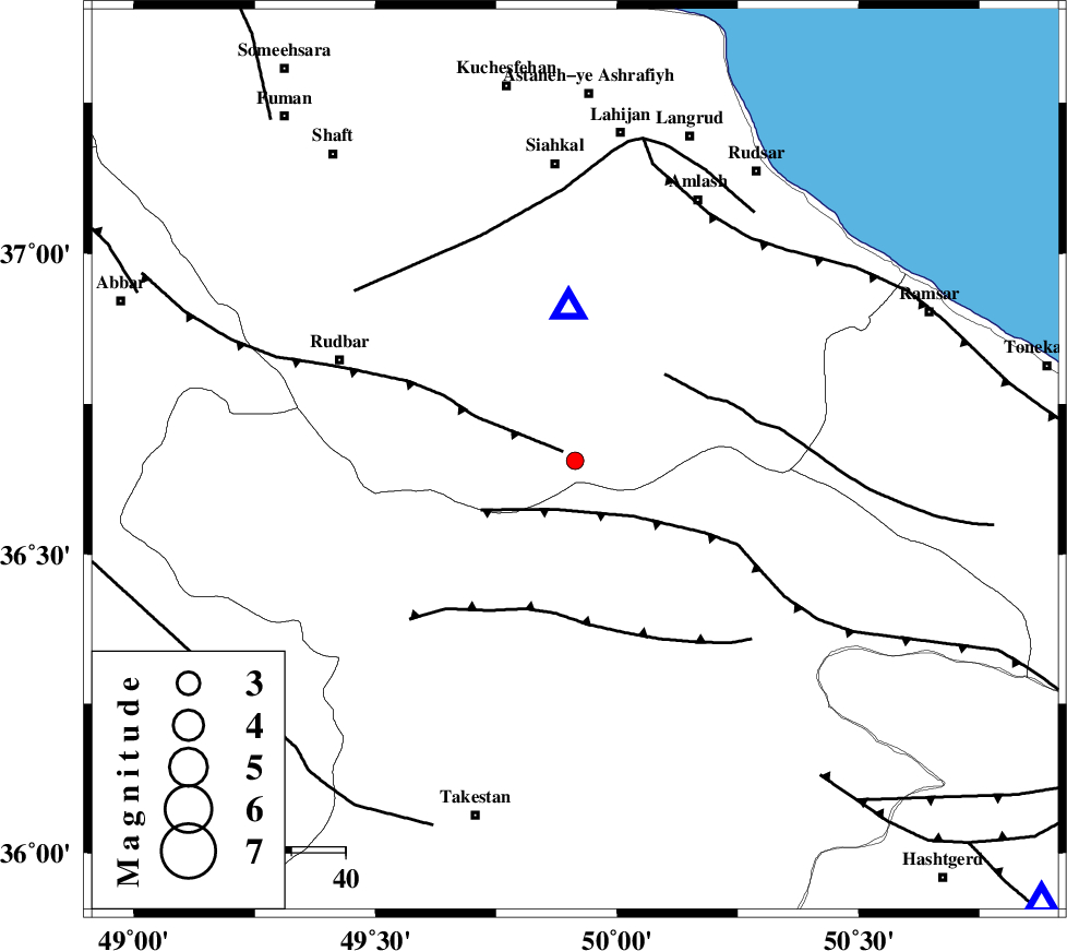
| Location | Lat:36.655 Lon: 49.913 |
| Region | Gilan Province, 44 km North of Qazvin |
Nearest Cities |
|
| 10 km of Kelishom, Gilan Province | |
| 12 km East of Jirhandeh, Gilan Province | |
| 23 km South of Barresar, Gilan Province | |
| 32 km South East of Dashtvil, Gilan Province | |
| 34 km North East of Kuhgir-e sofla, Ghazvin Province | |
| Depth | 15 km |
| Agency | |
Faults within 150 km: |
|
| RUDBAR_F (Length: 93 km) , Distance to epicenter: 3 km | |
| ALAMUTRUD_F (Length: 140 km) , Distance to epicenter: 10 km | |
| BONAN_F (Length: 74 km) , Distance to epicenter: 23 km | |
| Number of Phases | 5 |
| RMS | 0.5 |
| Number of Stations | 5 |
| Error in Latitude | >9 km |
| Error in Longitude | 8.6 km |
| Error in Depth | 8.3 km |
Download waveform in seisan format
to download seisan software Click here
to access information about IIEES stations Click here
Amplitude | ||||||||
| UID | Agency | Station | Component | Amplitude | Period | Arrival Time | Proccessing Time | Signal Clip |
| 100100 | IIEES | GHVR | N | 15.5 | 0.26 | 2015-07-15 15:09:27 | 2015-07-20 11:19:00 | n |
| 100101 | IIEES | GHVR | E | 16.7 | 0.3 | 2015-07-15 15:09:31 | 2015-07-20 11:19:00 | n |
Phase | ||||||||||||
| Agency | Station | Component | Phase Type | Phase Quality | First Motion | Observed Arrival Time | Time Residual | Loc. Flag | Input Weight | Distance | Azimuth | |
| IIEES | ZNJK | Z | Pg | E | 2015-07-15 15:07:40 | -0.55 | y | 110 | 271 | |||
| IIEES | CHTH | Z | Pg | E | 2015-07-15 15:07:44 | -0.66 | y | 137 | 127 | |||
| IIEES | ASAO | Z | Pn | E | 2015-07-15 15:07:59 | 0.46 | y | 234 | 177 | |||
| IIEES | GHVR | Z | Pn | E | 2015-07-15 15:08:04 | 0.39 | y | 270 | 153 | |||
| IIEES | GRMI | Z | P | E | 2015-07-15 15:08:07 | 0.4 | y | 298 | 324 | |||