| Prel. Rep. | Date | Time(UTC) | Time(Local) | Lat. | Lon. | Depth | Mag. | Region | Waveform |
|
|
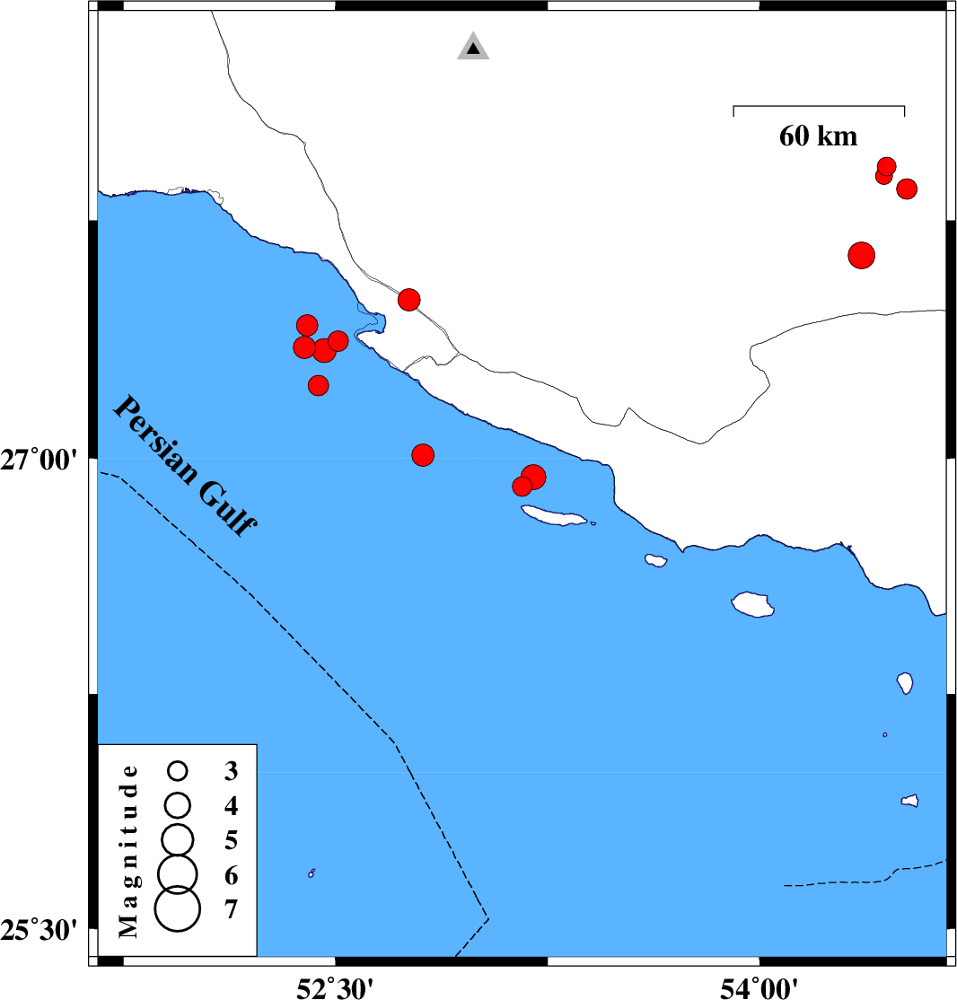
2006/10/17
|
13:39:33.4
|
17:09:33.4
| 26.91 | 53.16 | 45 |
ML:3.1
|
Persian Gulf, 47 km South of Lamerd | |
|
|
2006/10/17
|
12:17:18.2
|
15:47:18.2
| 26.94 | 53.2 | 37 |
ML:4
|
Persian Gulf, 43 km South of Lamerd | |
|
|
2006/10/16
|
03:49:34.7
|
07:19:34.7
| 27.85 | 54.52 | 14 |
ML:3.2
|
25 km North-East of Lar, Fars Province | |
|
|
2006/10/15
|
11:37:20.1
|
15:07:20.1
| 27.92 | 54.45 | 14 |
ML:2.9
|
29 km North-East of Lar, Fars Province | |
|
|
2006/10/14
|
06:08:13.1
|
09:38:13.1
| 27.89 | 54.44 | 14 |
ML:2.7
|
25 km North-East of Lar, Fars Province | |
|
|
2006/10/13
|
10:19:54.9
|
13:49:54.9
| 27.64 | 54.36 | 18 |
ML:4.3
|
4 km Lar, Fars Province | |
|
|
2006/09/27
|
09:42:18.5
|
13:12:18.5
| 27.5 | 52.76 | 15 |
ML:3.5
|
13 km West of Mehr, Fars Province | |
|
|
2006/09/27
|
01:04:00.9
|
04:34:00.9
| 27.01 | 52.81 | 25 |
ML:3.5
|
Persian Gulf, 50 km South-West of Lamerd | |
|
|
2006/09/24
|
01:46:26.1
|
05:16:26.1
| 27.37 | 52.51 | 18 |
ML:3.3
|
Persian Gulf, 42 km South-West of Mehr | |
|
|
2006/09/24
|
00:17:32.0
|
03:47:32.0
| 27.23 | 52.44 | 14 |
ML:3.3
|
Persian Gulf, 56 km South-West of Mehr | |
|
|
2006/09/23
|
22:50:25.2
|
02:20:25.2
| 27.42 | 52.4 | 15 |
ML:3.4
|
Persian Gulf, 47 km South of Jam | |
|
|
2006/09/23
|
10:27:05.5
|
13:57:05.5
| 27.35 | 52.39 | 14 |
ML:3.5
|
Persian Gulf, 53 km South-West of Mehr | |
|
|
2006/09/23
|
09:22:17.1
|
12:52:17.1
| 27.34 | 52.46 | 9 |
ML:3.8
|
Persian Gulf, 47 km South-West of Mehr | |
