| Prel. Rep. | Date | Time(UTC) | Time(Local) | Lat. | Lon. | Depth | Mag. | Region | Waveform |
|
|
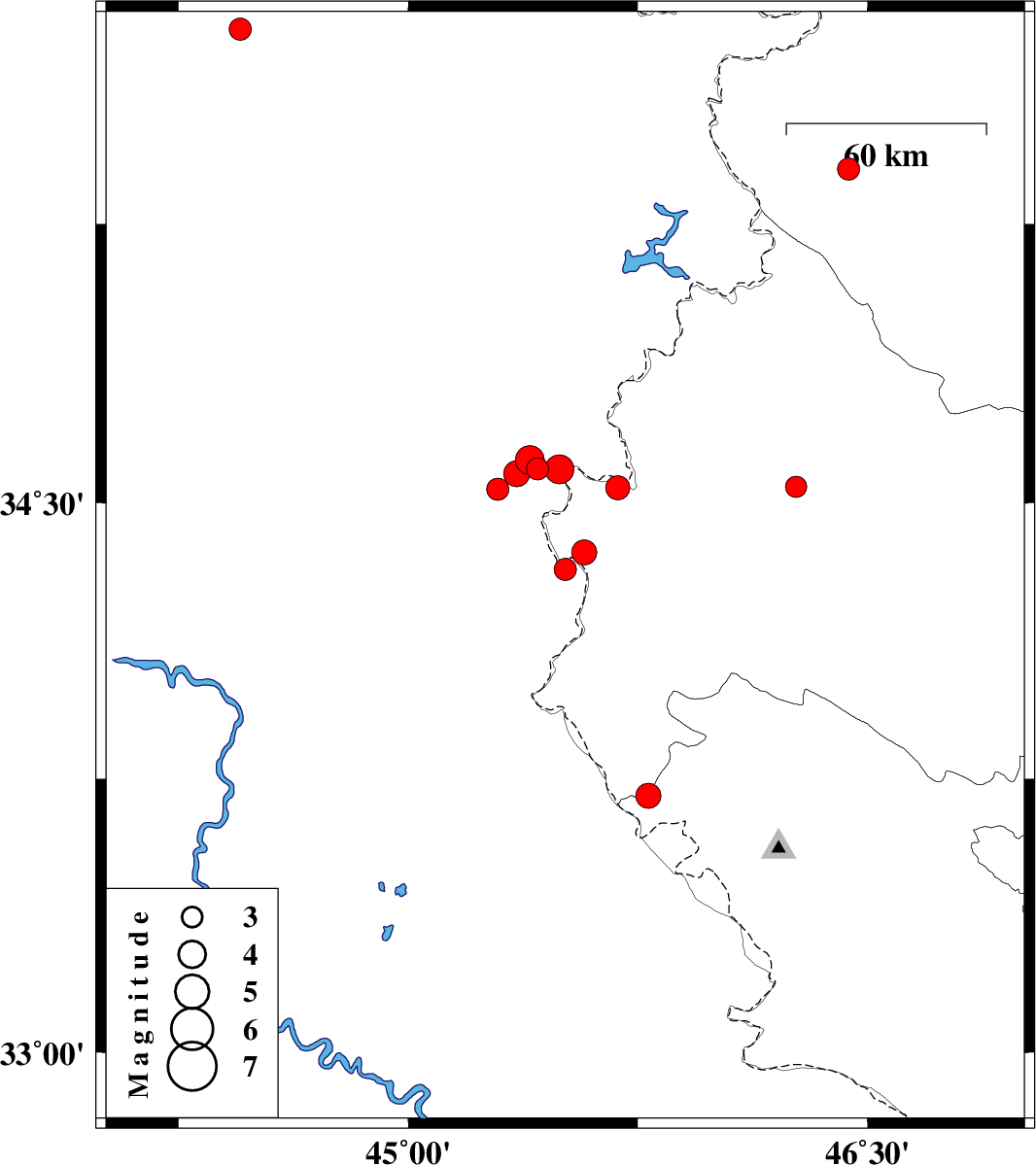
2021/10/13
|
18:28:10.8
|
21:58:10.8
| 34.366 | 45.575 | 12 |
ML:3.7
|
Kermanshah Province, 17 km South of Qasr-E-Shirin | |
|
|
2021/10/13
|
14:21:15.5
|
17:51:15.5
| 34.319 | 45.513 | 15 |
ML:3.2
|
Iraq, 23 km South of Qasr-E-Shirin | |
|
|
2021/10/05
|
20:12:35.5
|
23:42:35.5
| 33.703 | 45.785 | 12 |
ML:3.6
|
Ilam Province, 50 km South-West of Gilan-E-Gharb | |
|
|
2021/10/05
|
11:36:02.1
|
15:06:02.1
| 35.771 | 44.451 | 12 |
ML:3.2
|
Iraq, 92 km North-West of Sulaymaniyah | |
|
|
2021/10/02
|
23:14:06.6
|
02:44:06.6
| 34.543 | 46.268 | 10 |
ML:3.1
|
Kermanshah Province, 36 km -East of Sar-e pol-e zahab | |
|
|
2021/09/28
|
19:10:45.3
|
22:40:45.3
| 34.592 | 45.422 | 12 |
ML:3.2
|
Iraq, 17 km -West of Qasr-E-Shirin | |
|
|
2021/09/28
|
11:46:13.5
|
15:16:13.5
| 34.59 | 45.494 | 12 |
ML:4.3
|
Iraq, 12 km of Qasr-E-Shirin | |
|
|
2021/09/28
|
08:58:24.1
|
12:28:24.1
| 34.615 | 45.398 | 10 |
ML:4.2
|
Iraq, 20 km -West of Qasr-E-Shirin | |
|
|
2021/09/28
|
06:02:34.4
|
09:32:34.4
| 34.578 | 45.355 | 19 |
ML:3.8
|
Iraq, 22 km -West of Qasr-E-Shirin | |
|
|
2021/09/27
|
12:45:06.8
|
16:15:06.8
| 34.536 | 45.293 | 23 |
ML:3.2
|
Iraq, 27 km -West of Qasr-E-Shirin | |
|
|
2021/09/26
|
05:07:19.0
|
08:37:19.0
| 35.397 | 46.438 | 8 |
ML:3.3
|
Kurdistan Province, 29 km South-East of Marivan | |
|
|
2021/09/14
|
09:33:21.3
|
14:03:21.3
| 34.54 | 45.684 | 12 |
ML:3.5
|
Kermanshah Province, 10 km -East of Qasr-E-Shirin | |
