| Prel. Rep. | Date | Time(UTC) | Time(Local) | Lat. | Lon. | Depth | Mag. | Region | Waveform |
|
|
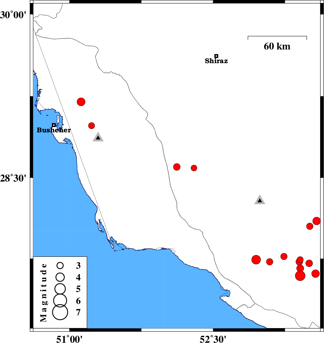
2020/07/18
|
17:00:07.4
|
21:30:07.4
| 28.6 | 52.12 | 10 |
ML:3.3
|
Fars Province, 30 km South of Farashband | |
|
|
2020/07/13
|
05:18:03.4
|
09:48:03.4
| 29.199 | 51.12 | 12 |
ML:3.8
|
Bushehr Province, 11 km of Borazjan | |
|
|
2020/07/13
|
02:02:35.0
|
06:32:35.0
| 27.707 | 53.503 | 8 |
ML:3.2
|
Fars Province, 53 km North-East of Lamerd | |
|
|
2020/07/10
|
20:14:07.5
|
00:44:07.5
| 27.59 | 53.41 | 16 |
ML:4.6
|
Fars Province, 37 km North-East of Lamerd | |
|
|
2020/07/07
|
17:40:43.1
|
22:10:43.1
| 27.66 | 53.41 | 21 |
ML:3.4
|
Fars Province, 44 km North-East of Lamerd | |
|
|
2020/07/04
|
09:04:28.1
|
13:34:28.1
| 27.61 | 53.57 | 10 |
ML:3.7
|
Fars Province, 50 km North-East of Lamerd | |
|
|
2020/07/04
|
09:01:56.5
|
13:31:56.5
| 27.72 | 53.09 | 10 |
ML:3.1
|
Fars Province, 28 km North-East of Mehr | |
|
|
2020/07/02
|
00:29:16.7
|
04:59:16.7
| 27.741 | 52.949 | 12 |
ML:4.2
|
Fars Province, 22 km North of Mehr | |
|
|
2020/06/28
|
23:05:33.5
|
03:35:33.5
| 27.77 | 53.24 | 10 |
ML:3.1
|
Fars Province, 49 km North of Lamerd | |
|
|
2020/06/28
|
00:34:48.6
|
05:04:48.6
| 28.98 | 51.23 | 10 |
ML:3
|
Bushehr Province, 12 km North of Ahram | |
|
|
2020/06/21
|
08:05:47.2
|
12:35:47.2
| 28.1 | 53.58 | 15 |
ML:3.7
|
Fars Province, 45 km South of Jahrom | |
|
|
2020/06/20
|
16:57:14.5
|
21:27:14.5
| 28.05 | 53.51 | 10 |
ML:3.1
|
Fars Province, 50 km South of Jahrom | |
|
|
2020/06/20
|
16:35:45.1
|
21:05:45.1
| 27.74 | 53.41 | 23 |
ML:3
|
Fars Province, 51 km North-East of Lamerd | |
|
|
2020/06/20
|
15:10:47.7
|
19:40:47.7
| 27.72 | 53.4 | 15 |
ML:3.3
|
Fars Province, 49 km North-East of Lamerd | |
|
|
2020/06/19
|
02:37:29.1
|
07:07:29.1
| 28.59 | 52.3 | 15 |
ML:2.8
|
Fars Province, 38 km South-East of Farashband | |
