
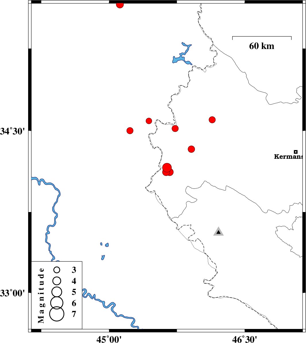
| Prel. Rep. | Date | Time(UTC) | Time(Local) | Lat. | Lon. | Depth | Mag. | Region | Waveform |
| 2020/05/18 | 17:24:25.8 | 21:54:25.8 | 34.16 | 45.64 | 10 | ML:4.5 | Kermanshah Province, 25 km -West of Gilan-E-Gharb | ||
| 2020/05/17 | 00:05:25.1 | 04:35:25.1 | 35.65 | 45.12 | 10 | ML:3.6 | Iraq, 31 km -West of Sulaymaniyah | ||
| 2020/05/11 | 23:47:28.0 | 04:17:28.0 | 34.33 | 45.91 | 14 | ML:3.4 | Kermanshah Province, 15 km South of Sar-e pol-e zahab | ||
| 2020/05/05 | 02:03:41.2 | 06:33:41.2 | 34.12 | 45.63 | 11 | ML:3.7 | Kermanshah Province, 26 km -West of Gilan-E-Gharb | ||
| 2020/05/02 | 11:35:05.2 | 16:05:05.2 | 34.12 | 45.67 | 10 | ML:3.6 | Kermanshah Province, 23 km -West of Gilan-E-Gharb | ||
| 2020/04/20 | 21:28:04.4 | 01:58:04.4 | 34.5 | 45.23 | 10 | ML:3.3 | Iraq, 32 km -West of Qasr-E-Shirin | ||
| 2020/04/20 | 12:22:41.1 | 16:52:41.1 | 34.52 | 45.73 | 10 | ML:3.3 | Kermanshah Province, 13 km -East of Qasr-E-Shirin | ||
| 2020/04/20 | 06:17:04.2 | 10:47:04.2 | 34.59 | 45.44 | 10 | ML:3 | Iraq, 15 km -West of Qasr-E-Shirin | ||
| 2020/04/18 | 21:43:06.6 | 02:13:06.6 | 34.6 | 46.14 | 10 | ML:3.2 | Kermanshah Province, 28 km North-East of Sar-e pol-e zahab |