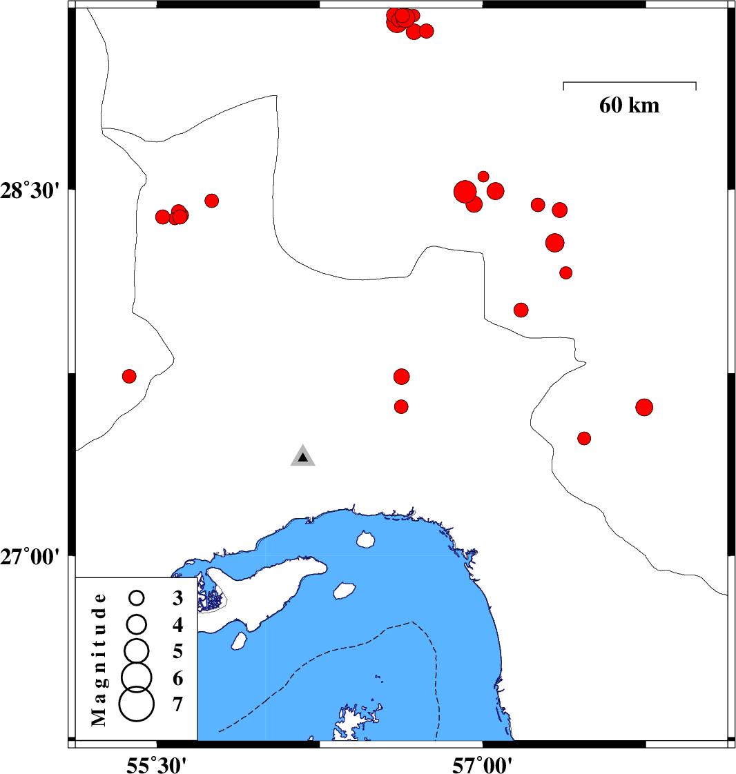
| Prel. Rep. | Date | Time(UTC) | Time(Local) | Lat. | Lon. | Depth | Mag. | Region | Waveform |
|
|
2017/02/03
|
15:33:52.3
|
19:03:52.3
| 27.735 | 56.626 | 14 |
ML:3.3
|
Hormozgan Province, 70 km North-East of Bandar-e abbas | |
|
|
2017/01/29
|
01:58:51.2
|
05:28:51.2
| 29.204 | 56.629 | 23 |
ML:3
|
Kerman Province, 4 km of Baft | |
|
|
2017/01/28
|
17:32:07.0
|
21:02:07.0
| 28.416 | 57.353 | 18 |
ML:3.1
|
Kerman Province, 47 km South-West of Jiroft | |
|
|
2017/01/28
|
01:11:31.0
|
04:41:31.0
| 29.141 | 56.74 | 18 |
ML:2.9
|
Kerman Province, 16 km -East of Baft | |
|
|
2017/01/28
|
00:18:28.8
|
03:48:28.8
| 29.194 | 56.643 | 17 |
ML:4
|
Kerman Province, 6 km of Baft | |
|
|
2017/01/26
|
23:49:38.1
|
03:19:38.1
| 29.187 | 56.614 | 9 |
ML:3
|
Kerman Province, 5 km of Baft | |
|
|
2017/01/26
|
17:48:17.8
|
21:18:17.8
| 29.204 | 56.682 | 18 |
ML:2.6
|
Kerman Province, 8 km of Baft | |
|
|
2017/01/26
|
13:10:49.8
|
16:40:49.8
| 29.206 | 56.592 | 16 |
ML:3.1
|
Kerman Province, 4 km of Baft | |
|
|
2017/01/25
|
12:36:47.1
|
16:06:47.1
| 28.551 | 57.003 | 14 |
ML:2.2
|
Kerman Province, 73 km South-West of Jiroft | |
|
|
2017/01/25
|
05:41:43.5
|
09:11:43.5
| 28.49 | 56.919 | 15 |
ML:4.6
|
Kerman Province, 83 km South-West of Jiroft | |
|
|
2017/01/25
|
05:36:02.1
|
09:06:02.1
| 28.44 | 56.959 | 14 |
ML:3.4
|
Kerman Province, 80 km South-West of Jiroft | |
|
|
2017/01/25
|
05:35:00.4
|
09:05:00.4
| 28.492 | 57.058 | 18 |
ML:3.5
|
Kerman Province, 69 km South-West of Jiroft | |
|
|
2017/01/22
|
18:07:50.2
|
21:37:50.2
| 29.139 | 56.684 | 18 |
ML:3.3
|
Kerman Province, 13 km of Baft | |
|
|
2017/01/21
|
15:15:04.8
|
18:45:04.8
| 29.2 | 56.662 | 15 |
ML:2.9
|
Kerman Province, 6 km of Baft | |
|
|
2017/01/21
|
08:23:14.1
|
11:53:14.1
| 29.178 | 56.605 | 29 |
ML:4.4
|
Kerman Province, 6 km of Baft | |
|
|
2017/01/17
|
13:45:23.8
|
17:15:23.8
| 27.482 | 57.466 | 24 |
ML:2.7
|
Kerman Province, 9 km of Manujan | |
|
|
2017/01/17
|
03:50:26.0
|
07:20:26.0
| 28.282 | 57.331 | 18 |
ML:3.8
|
Kerman Province, 51 km North-West of Kahnuj | |
|
|
2017/01/16
|
13:00:00.1
|
16:30:00.1
| 28.453 | 55.753 | 14 |
ML:2.8
|
Hormozgan Province, 22 km North-West of Hajiabad | |
|
|
2017/01/15
|
22:13:22.8
|
01:43:22.8
| 28.387 | 55.607 | 18 |
ML:2.9
|
Hormozgan Province, 30 km -West of Hajiabad | |
|
|
2017/01/15
|
17:51:11.7
|
21:21:11.7
| 28.388 | 55.527 | 15 |
ML:2.9
|
Hormozgan Province, 38 km -West of Hajiabad | |
|
|
2017/01/15
|
16:41:15.8
|
20:11:15.8
| 28.381 | 55.583 | 18 |
ML:2.6
|
Hormozgan Province, 32 km -West of Hajiabad | |
|
|
2017/01/15
|
16:36:57.3
|
20:06:57.3
| 28.408 | 55.601 | 14 |
ML:3
|
Hormozgan Province, 31 km -West of Hajiabad | |
|
|
2017/01/15
|
16:28:19.6
|
19:58:19.6
| 28.394 | 55.611 | 17 |
ML:3.1
|
Hormozgan Province, 30 km -West of Hajiabad | |
|
|
2017/01/14
|
18:45:49.0
|
22:15:49.0
| 27.737 | 55.374 | 14 |
ML:2.8
|
Fars Province, 102 km -East of Lar | |
|
|
2017/01/14
|
08:43:03.3
|
12:13:03.3
| 28.16 | 57.382 | 14 |
ML:2.6
|
Kerman Province, 39 km North-West of Kahnuj | |
|
|
2017/01/13
|
10:07:21.3
|
13:37:21.3
| 27.61 | 57.742 | 14 |
ML:3.5
|
Kerman Province, 38 km South of Kahnuj | |
|
|
2017/01/10
|
17:28:04.7
|
20:58:04.7
| 27.613 | 56.625 | 17 |
ML:2.8
|
Hormozgan Province, 59 km North-East of Bandar-e abbas | |
|
|
2017/01/09
|
08:12:00.6
|
11:42:00.6
| 28.007 | 57.175 | 16 |
ML:2.9
|
Kerman Province, 51 km -West of Kahnuj | |
|
|
2017/01/04
|
17:57:49.1
|
21:27:49.1
| 28.437 | 57.254 | 16 |
ML:2.8
|
Kerman Province, 54 km South-West of Jiroft | |