
Magnitude |
:3.1 |
| Date & Time (UTC) | 2014-08-16 07:42:23.5 |
| Date & Time (Local) | 1393/5/25 12:12:23.5 |
| Location | Lat:27.83 Lon: 58.56 |
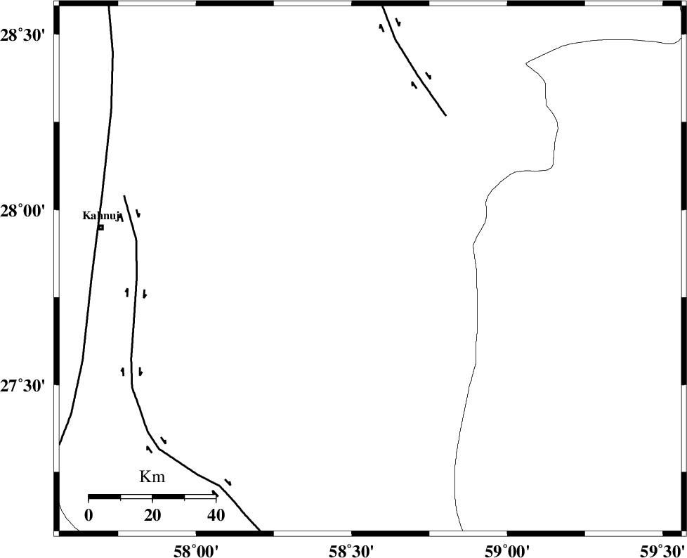
| Region | Kerman Province, 86 km South-East of Kahnuj |
Nearest Cities |
|
| 22 km South of Borj-e abbasabad, Kerman Province | |
| 69 km South East of Mardehak, Kerman Province | |
| 75 km North East of Qalehy-eganj, Kerman Province | |
| 86 km South East of Kahnuj, Kerman Province | |
| 89 km South East of Dosari, Kerman Province | |
| Depth | 15 km |
| Agency | |
Faults within 150 km: |
|
| BAM_F (Length: 118 km) , Distance to epicenter: 54 km | |
| JIROFT_F (Length: 144 km) , Distance to epicenter: 74 km | |
| SABZEVARAN_F (Length: 190 km) , Distance to epicenter: 88 km | |
| Number of Phases | 5 |
| RMS | 0.1 |
| Number of Stations | 5 |
| Error in Latitude | >3.8 km |
| Error in Longitude | 1.2 km |
| Error in Depth | 0 km |
Download waveform in seisan format
to download seisan software Click here
to access information about IIEES stations Click here
Amplitude | ||||||||
| UID | Agency | Station | Component | Amplitude | Period | Arrival Time | Proccessing Time | Signal Clip |
| 92938 | IIEES | BNDS | N | 152.9 | 0.16 | 2014-08-16 07:43:03 | 2014-08-16 09:23:00 | n |
| 92939 | IIEES | BNDS | E | 158.8 | 0.12 | 2014-08-16 07:43:03 | 2014-08-16 09:23:00 | n |
| 92940 | IIEES | BSRN | E | 13.8 | 0.35 | 2014-08-16 07:44:34 | 2014-08-16 09:23:00 | n |
Phase | ||||||||||||
| Agency | Station | Component | Phase Type | Phase Quality | First Motion | Observed Arrival Time | Time Residual | Loc. Flag | Input Weight | Distance | Azimuth | |
| IIEES | BNDS | Z | Pn | E | 2014-08-16 07:43:01 | 0.03 | y | 240 | 259 | |||
| IIEES | ZHSF | Z | Pn | E | 2014-08-16 07:43:07 | -0.06 | y | 293 | 47 | |||
| IIEES | BSRN | Z | Pn | E | 2014-08-16 07:43:28 | 0.06 | y | 462 | 7 | |||
| IIEES | YZKH | Z | Pn | E | 2014-08-16 07:43:49 | -0.16 | y | 634 | 324 | |||
| IIEES | SHRT | Z | Pn | E | 2014-08-16 07:43:54 | 0.14 | y | 666 | 14 | |||