
Magnitude |
:2.4 |
| Date & Time (UTC) | 2014-01-19 22:47:22.1 |
| Date & Time (Local) | 1392/10/30 02:17:22.1 |
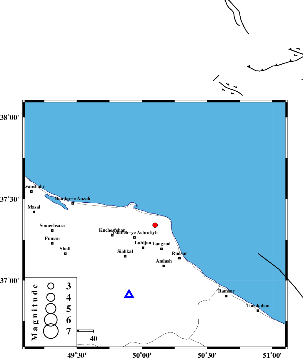
| Location | Lat:37.34 Lon: 50.1 |
| Region | Gilan Province, 16 km North of Langarud |
Nearest Cities |
|
| 5 km of Dehgah, Gilan Province | |
| 7 km North of Dehshal, Gilan Province | |
| 10 km North of Latlil, Gilan Province | |
| 13 km North West of Chali-ye paeen, Gilan Province | |
| 15 km East of Kiashahr, Gilan Province | |
| Depth | 15 km |
| Agency | |
Faults within 150 km: |
|
| KHAZAR_F (Length: 523 km) , Distance to epicenter: 17 km | |
| LAHIJAN_F (Length: 92 km) , Distance to epicenter: 17 km | |
| BONAN_F (Length: 74 km) , Distance to epicenter: 60 km | |
| Number of Phases | 5 |
| RMS | 0.1 |
| Number of Stations | 4 |
| Error in Latitude | >3.5 km |
| Error in Longitude | 2.5 km |
| Error in Depth | 5.7 km |
Download waveform in seisan format
to download seisan software Click here
to access information about IIEES stations Click here
Amplitude | ||||||||
| UID | Agency | Station | Component | Amplitude | Period | Arrival Time | Proccessing Time | Signal Clip |
| 91551 | IIEES | ZNJK | N | 55.8 | 0.28 | 2014-01-19 22:48:06 | 2014-01-20 02:29:00 | n |
| 91552 | IIEES | ZNJK | E | 50.2 | 0.2 | 2014-01-19 22:48:07 | 2014-01-20 02:29:00 | n |
| 91553 | IIEES | THKV | E | 78 | 0.48 | 2014-01-19 22:48:01 | 2014-01-20 02:29:00 | n |
Phase | ||||||||||||
| Agency | Station | Component | Phase Type | Phase Quality | First Motion | Observed Arrival Time | Time Residual | Loc. Flag | Input Weight | Distance | Azimuth | |
| IIEES | ZNJK | Z | Pg | E | 2014-01-19 22:47:46 | 0.21 | y | 146 | 240 | |||
| IIEES | ZNJK | E | Sg | E | 2014-01-19 22:48:04 | -0.16 | y | 146 | 240 | |||
| IIEES | CHTH | Z | Pg | E | 2014-01-19 22:47:52 | -0.13 | y | 183 | 150 | |||
| IIEES | ASAO | Z | Pn | E | 2014-01-19 22:48:08 | 0 | y | 309 | 181 | |||
| IIEES | ASAO | E | Sg | E | 2014-01-19 22:48:49 | 0.09 | y | 309 | 181 | |||