
Magnitude |
:3.4 |
| Date & Time (UTC) | 2014-01-18 19:59:34.6 |
| Date & Time (Local) | 1392/10/28 23:29:34.6 |
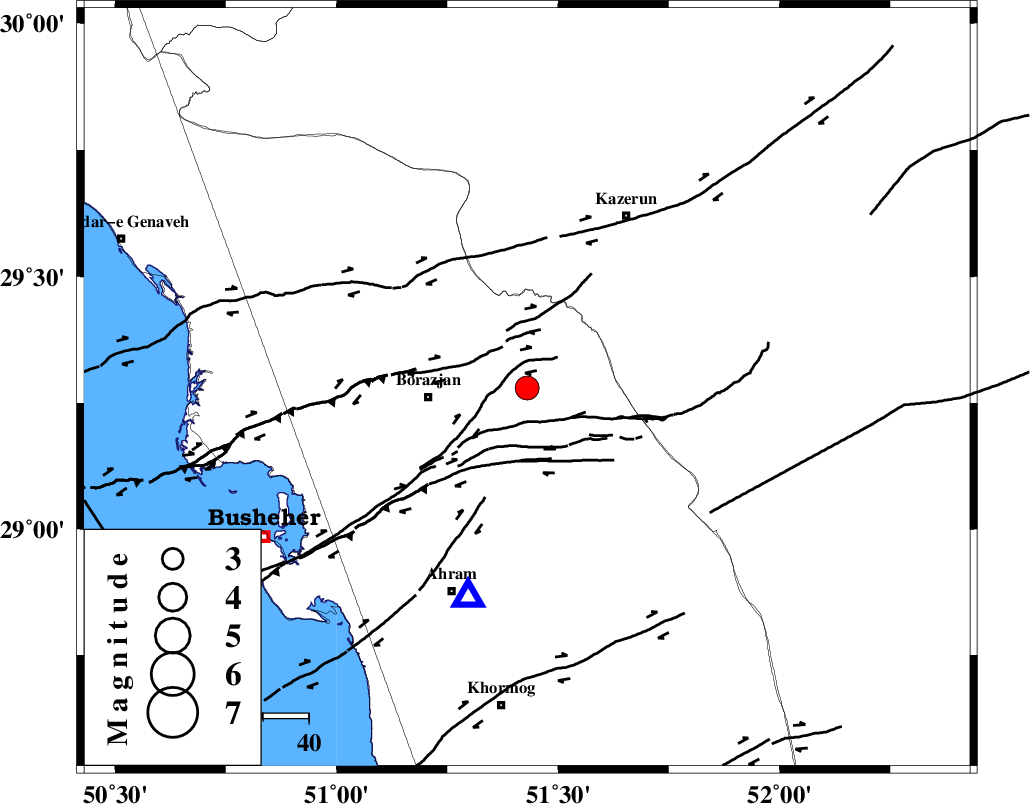
| Location | Lat:29.28 Lon: 51.43 |
| Region | Bushehr Province, 22 km East of Borazjan |
Nearest Cities |
|
| 21 km South East of Dalki, Bushehr Province | |
| 22 km North East of Borazjan, Bushehr Province | |
| 24 km North East of Sarkareh, Bushehr Province | |
| 26 km East of Nazar aqa, Bushehr Province | |
| 32 km East of Saedabad, Bushehr Province | |
| Depth | 9 km |
| Agency | |
Faults within 150 km: |
|
| BORAZJAN_F (Length: 168 km) , Distance to epicenter: 13 km | |
| ZFF3 (Length: 125 km) , Distance to epicenter: 20 km | |
| KAZERUN_F (Length: 96 km) , Distance to epicenter: 35 km | |
| Number of Phases | 6 |
| RMS | 0.1 |
| Number of Stations | 6 |
| Error in Latitude | >6.4 km |
| Error in Longitude | 4.8 km |
| Error in Depth | 13.4 km |
Download waveform in seisan format
to download seisan software Click here
to access information about IIEES stations Click here
Amplitude | ||||||||
| UID | Agency | Station | Component | Amplitude | Period | Arrival Time | Proccessing Time | Signal Clip |
| 91541 | IIEES | SHGR | E | 128.4 | 0.48 | 2014-01-18 20:01:16 | 2014-01-18 08:38:00 | n |
| 91542 | IIEES | SHGR | N | 148.8 | 0.4 | 2014-01-18 20:01:16 | 2014-01-18 08:38:00 | n |
| 91543 | IIEES | YZKH | N | 16 | 0.44 | 2014-01-18 20:01:37 | 2014-01-18 08:38:00 | n |
Phase | ||||||||||||
| Agency | Station | Component | Phase Type | Phase Quality | First Motion | Observed Arrival Time | Time Residual | Loc. Flag | Input Weight | Distance | Azimuth | |
| IIEES | AHRM | Z | Pg | E | 2014-01-18 19:59:43 | 0.03 | y | 47.6 | 196 | |||
| IIEES | YZKH | Z | Pn | E | 2014-01-18 20:00:40 | 0.01 | y | 459 | 40 | |||
| IIEES | YZKH | N | S | E | 2014-01-18 20:01:27 | 0.07 | y | 459 | 40 | |||
| IIEES | KHMZ | Z | Pn | E | 2014-01-18 20:00:46 | 0.02 | y | 514 | 345 | |||
| IIEES | KRBR | Z | Pn | E | 2014-01-18 20:00:47 | -0.1 | y | 522 | 80 | |||
| IIEES | SNGE | Z | Pn | E | 2014-01-18 20:01:16 | -0.09 | y | 751 | 330 | |||