
Magnitude |
:3.3 |
| Date & Time (UTC) | 2013-12-03 11:08:46.8 |
| Date & Time (Local) | 1392/9/12 14:38:46.8 |
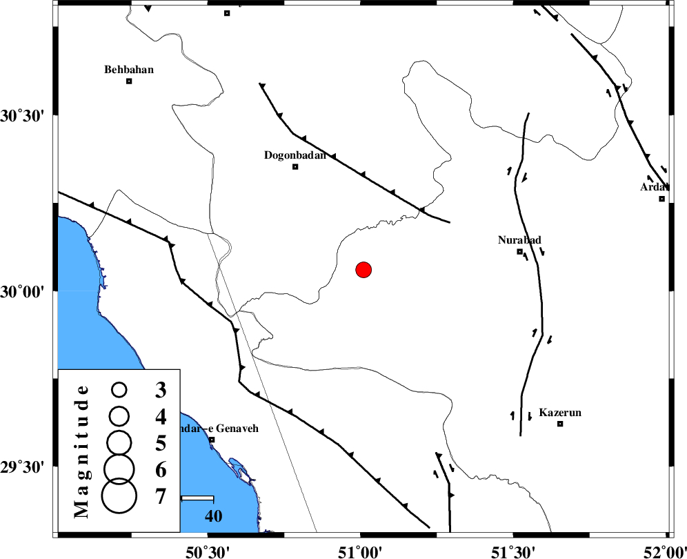
| Location | Lat:30.06 Lon: 51.01 |
| Region | Fars Province, 39 km South-East of Dogonbadan |
Nearest Cities |
|
| 18 km West of Babamonir, Fars Province | |
| 36 km South West of Basht, Kohkiluieh va boyerahmad Province | |
| 39 km South East of Dogonbadan, Kohkiluieh va boyerahmad Province | |
| 40 km West of Ahangari, Fars Province | |
| 41 km South West of Kopon olia, Fars Province | |
| Depth | 14 km |
| Agency | |
Faults within 150 km: |
|
| MISHAN_F (Length: 76 km) , Distance to epicenter: 27 km | |
| ZFF3 (Length: 125 km) , Distance to epicenter: 45 km | |
| KAZERUN_F (Length: 96 km) , Distance to epicenter: 52 km | |
| Number of Phases | 4 |
| RMS | 0.2 |
| Number of Stations | 3 |
| Error in Latitude | >3.5 km |
| Error in Longitude | 5.2 km |
| Error in Depth | 7.6 km |
Download waveform in seisan format
to download seisan software Click here
to access information about IIEES stations Click here
Amplitude | ||||||||
| UID | Agency | Station | Component | Amplitude | Period | Arrival Time | Proccessing Time | Signal Clip |
| 91136 | IIEES | SHGR | N | 117.2 | 0.48 | 2013-12-03 11:10:30 | 2013-12-03 12:04:00 | n |
| 91137 | IIEES | SHGR | E | 95.1 | 0.56 | 2013-12-03 11:10:34 | 2013-12-03 12:04:00 | n |
Phase | ||||||||||||
| Agency | Station | Component | Phase Type | Phase Quality | First Motion | Observed Arrival Time | Time Residual | Loc. Flag | Input Weight | Distance | Azimuth | |
| IIEES | AHRM | Z | Pg | E | 2013-12-03 11:09:09 | -0.06 | y | 135 | 168 | |||
| IIEES | SHGR | Z | Pn | E | 2013-12-03 11:09:33 | 0.28 | y | 310 | 318 | |||
| IIEES | SHGR | N | Sg | E | 2013-12-03 11:10:13 | -0.16 | y | 310 | 318 | |||
| IIEES | YZKH | Z | Pn | E | 2013-12-03 11:09:47 | -0.06 | y | 428 | 52 | |||