
Magnitude |
:2.7 |
| Date & Time (UTC) | 2013-12-01 05:29:22.9 |
| Date & Time (Local) | 1392/9/10 08:59:22.9 |
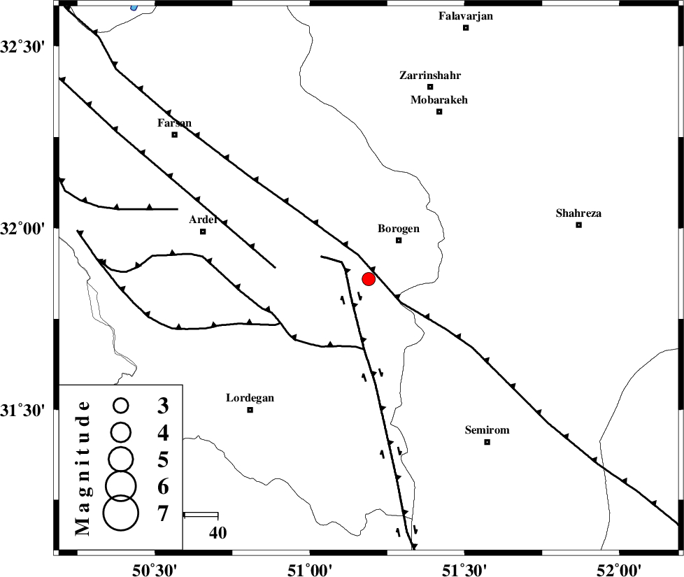
| Location | Lat:31.86 Lon: 51.19 |
| Region | Chaharmahal Bakhtiari Province, 15 km South-West of Borujen |
Nearest Cities |
|
| 3 km of Gandoman, Chaharmahal Bakhtiari Province | |
| 15 km South of Borujen, Chaharmahal Bakhtiari Province | |
| 15 km East of Baladaji, Chaharmahal Bakhtiari Province | |
| 15 km South of Faradonbeh, Chaharmahal Bakhtiari Province | |
| 27 km West of Hamgin, Esfahan Province | |
| Depth | 18 km |
| Agency | |
Faults within 150 km: |
|
| DENA_F (Length: 137 km) , Distance to epicenter: 8 km | |
| MAIN_ZAGROS_R_F (Length: 1106 km) , Distance to epicenter: 8 km | |
| DOPOLAN_F (Length: 107 km) , Distance to epicenter: 21 km | |
| Number of Phases | 6 |
| RMS | 0.1 |
| Number of Stations | 5 |
| Error in Latitude | >4.4 km |
| Error in Longitude | 3.1 km |
| Error in Depth | 8.2 km |
Download waveform in seisan format
to download seisan software Click here
to access information about IIEES stations Click here
Amplitude | ||||||||
| UID | Agency | Station | Component | Amplitude | Period | Arrival Time | Proccessing Time | Signal Clip |
| 91120 | IIEES | SHGR | N | 99 | 0.73 | 2013-12-01 05:30:42 | 2013-12-01 06:11:00 | n |
| 91121 | IIEES | SHGR | E | 73 | 0.65 | 2013-12-01 05:30:43 | 2013-12-01 06:11:00 | n |
| 91122 | IIEES | KHMZ | E | 38.9 | 0.47 | 2013-12-01 05:30:42 | 2013-12-01 06:11:00 | n |
| 91123 | IIEES | KHMZ | N | 42.8 | 0.74 | 2013-12-01 05:30:42 | 2013-12-01 06:11:00 | n |
| 91124 | IIEES | GHVR | N | 27.4 | 0.62 | 2013-12-01 05:30:54 | 2013-12-01 06:11:00 | n |
| 91125 | IIEES | GHVR | E | 27.6 | 0.58 | 2013-12-01 05:30:54 | 2013-12-01 06:11:00 | n |
Phase | ||||||||||||
| Agency | Station | Component | Phase Type | Phase Quality | First Motion | Observed Arrival Time | Time Residual | Loc. Flag | Input Weight | Distance | Azimuth | |
| IIEES | SHGR | Z | Pn | E | 2013-12-01 05:29:58 | 0.02 | y | 227 | 277 | |||
| IIEES | SHGR | N | Sg | E | 2013-12-01 05:30:27 | 0.02 | y | 227 | 277 | |||
| IIEES | KHMZ | Z | Pn | E | 2013-12-01 05:29:59 | -0.09 | y | 237 | 332 | |||
| IIEES | GHVR | Z | Pn | E | 2013-12-01 05:30:06 | 0.27 | y | 290 | 1 | |||
| IIEES | ASAO | Z | Pn | E | 2013-12-01 05:30:09 | -0.21 | y | 317 | 340 | |||
| IIEES | YZKH | Z | Pn | E | 2013-12-01 05:30:11 | -0.02 | y | 327 | 79 | |||