
Magnitude |
:4 |
| Date & Time (UTC) | 2013-09-24 15:45:23.6 |
| Date & Time (Local) | 1392/7/2 19:15:23.6 |
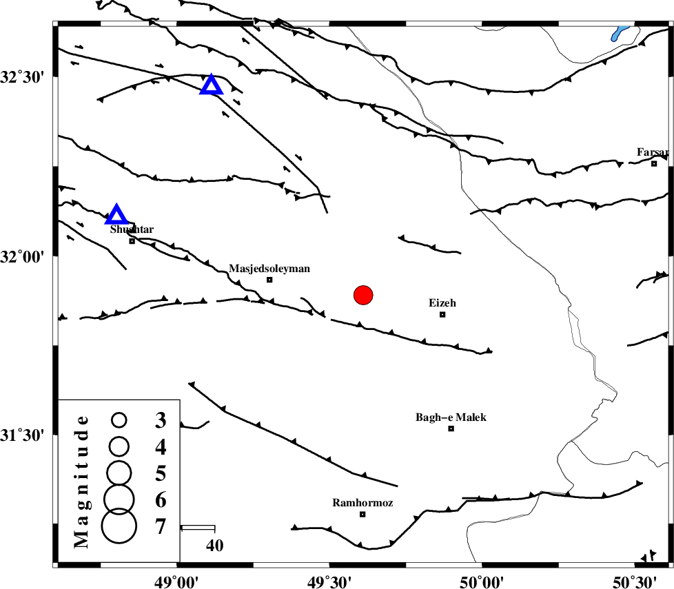
| Location | Lat:31.89 Lon: 49.61 |
| Region | Khoozestan Province, 26 km West of Izeh |
Nearest Cities |
|
| 19 km North West of Rasvand, Khoozestan Province | |
| 20 km North West of Chenarestan, Khoozestan Province | |
| 24 km South West of Torshak, Khoozestan Province | |
| 25 km North West of Izeh, Khoozestan Province | |
| 29 km East of Masjed Soleyman, Khoozestan Province | |
| Depth | 14 km |
| Agency | |
Faults within 150 km: |
|
| MFF2 (Length: 205 km) , Distance to epicenter: 16 km | |
| DEZFUL_EMBAYMENT (Length: 228 km) , Distance to epicenter: 25 km | |
| ZARDKUH_F (Length: 139 km) , Distance to epicenter: 61 km | |
| Number of Phases | 6 |
| RMS | 0.1 |
| Number of Stations | 5 |
| Error in Latitude | >3 km |
| Error in Longitude | 2.9 km |
| Error in Depth | 6.7 km |
Download waveform in seisan format
to download seisan software Click here
to access information about IIEES stations Click here
Amplitude | ||||||||
| UID | Agency | Station | Component | Amplitude | Period | Arrival Time | Proccessing Time | Signal Clip |
| 90622 | IIEES | SHGR | N | 4473.9 | 0.4 | 2013-09-24 15:45:51 | 2013-09-24 05:09:00 | n |
| 90623 | IIEES | AHRM | E | 356.5 | 0.4 | 2013-09-24 15:46:58 | 2013-09-24 05:09:00 | n |
| 90624 | IIEES | AHRM | N | 407.6 | 0.44 | 2013-09-24 15:46:59 | 2013-09-24 05:09:00 | n |
Phase | ||||||||||||
| Agency | Station | Component | Phase Type | Phase Quality | First Motion | Observed Arrival Time | Time Residual | Loc. Flag | Input Weight | Distance | Azimuth | |
| IIEES | SHGR | Z | Pg | E | 2013-09-24 15:45:37 | -0.05 | y | 79.9 | 288 | |||
| IIEES | SHGR | N | Sg | E | 2013-09-24 15:45:47 | 0.02 | y | 79.9 | 288 | |||
| IIEES | ASAO | Z | Pn | E | 2013-09-24 15:46:08 | 0.22 | y | 297 | 7 | |||
| IIEES | ASAO | E | Sg | E | 2013-09-24 15:46:47 | -0.09 | y | 297 | 7 | |||
| IIEES | GHVR | Z | Pn | E | 2013-09-24 15:46:11 | 0.05 | y | 325 | 28 | |||
| IIEES | YZKH | Z | Pn | E | 2013-09-24 15:46:30 | -0.2 | y | 473 | 82 | |||