
Magnitude |
:1.7 |
| Date & Time (UTC) | 2013-09-04 09:34:19.1 |
| Date & Time (Local) | 1392/6/13 14:04:19.1 |
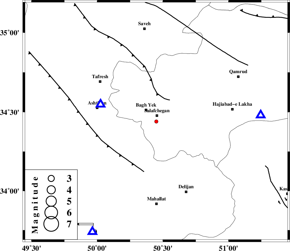
| Location | Lat:34.44 Lon: 50.45 |
| Region | Qom Province, 42 km East of Ashtiyan |
Nearest Cities |
|
| 4 km of Salafchegan, Qom Province | |
| 11 km of Bagh yek, Qom Province | |
| 22 km South East of Dastjerd, Qom Province | |
| 24 km North East of Salehabad, Markazi Province | |
| 36 km North West of Dudhak, Markazi Province | |
| Depth | 38 km |
| Agency | |
Faults within 150 km: |
|
| INDES_F (Length: 98 km) , Distance to epicenter: 17 km | |
| TAFRESH_F (Length: 117 km) , Distance to epicenter: 36 km | |
| KUSHK_E_NOSRAT_F (Length: 230 km) , Distance to epicenter: 67 km | |
| Number of Phases | 5 |
| RMS | 0.1 |
| Number of Stations | 3 |
| Error in Latitude | >2.7 km |
| Error in Longitude | 3.5 km |
| Error in Depth | 8.6 km |
Download waveform in seisan format
to download seisan software Click here
to access information about IIEES stations Click here
Amplitude | ||||||||
| UID | Agency | Station | Component | Amplitude | Period | Arrival Time | Proccessing Time | Signal Clip |
| 90456 | IIEES | GHVR | N | 37.4 | 0.17 | 2013-09-04 09:34:45 | 2013-09-04 10:54:00 | n |
| 90457 | IIEES | GHVR | E | 41.6 | 0.39 | 2013-09-04 09:34:47 | 2013-09-04 10:54:00 | n |
| 90458 | IIEES | KHMZ | N | 19 | 0.42 | 2013-09-04 09:34:47 | 2013-09-04 10:54:00 | n |
| 90459 | IIEES | KHMZ | E | 17.5 | 0.16 | 2013-09-04 09:34:53 | 2013-09-04 10:54:00 | n |
Phase | ||||||||||||
| Agency | Station | Component | Phase Type | Phase Quality | First Motion | Observed Arrival Time | Time Residual | Loc. Flag | Input Weight | Distance | Azimuth | |
| IIEES | ASAO | Z | Pg | E | 2013-09-04 09:34:28 | -0.14 | y | 40.3 | 287 | |||
| IIEES | ASAO | E | Sg | E | 2013-09-04 09:34:35 | 0.08 | y | 40.3 | 287 | |||
| IIEES | GHVR | Z | Pg | E | 2013-09-04 09:34:32 | 0 | y | 73.6 | 87 | |||
| IIEES | KHMZ | Z | Pg | E | 2013-09-04 09:34:35 | 0.14 | y | 89.8 | 210 | |||
| IIEES | KHMZ | E | Sg | E | 2013-09-04 09:34:46 | -0.08 | y | 89.8 | 210 | |||