
Magnitude |
:3.2 |
| Date & Time (UTC) | 2013-06-15 00:30:11.5 |
| Date & Time (Local) | 1392/3/25 05:00:11.5 |
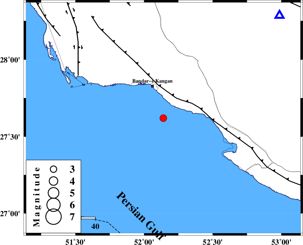
| Location | Lat:27.62 Lon: 52.14 |
| Region | Persian Gulf, 24 km South of Bandar-e kangan |
Nearest Cities |
|
| 20 km West of Bandar-e taheri, Bushehr Province | |
| 24 km South of Bandar-e kangan, Bushehr Province | |
| 29 km South West of Jam, Bushehr Province | |
| 48 km South of Riz, Bushehr Province | |
| 49 km North West of Bandar-e asaluyeh, Bushehr Province | |
| Depth | 17 km |
| Agency | |
Faults within 150 km: |
|
| MFF3 (Length: 292 km) , Distance to epicenter: 17 km | |
| BORAZJAN_F (Length: 168 km) , Distance to epicenter: 68 km | |
| MFF5 (Length: 74 km) , Distance to epicenter: 84 km | |
| Number of Phases | 5 |
| RMS | 0 |
| Number of Stations | 3 |
| Error in Latitude | >3.6 km |
| Error in Longitude | 1.4 km |
| Error in Depth | 4.6 km |
Download waveform in seisan format
to download seisan software Click here
to access information about IIEES stations Click here
Amplitude | ||||||||
| UID | Agency | Station | Component | Amplitude | Period | Arrival Time | Proccessing Time | Signal Clip |
| 89644 | IIEES | GHIR | E | 805.6 | 0.52 | 2013-06-15 00:30:50 | 2013-06-15 01:58:00 | n |
| 89645 | IIEES | AHRM | N | 310.5 | 0.6 | 2013-06-15 00:31:07 | 2013-06-15 01:58:00 | n |
Phase | ||||||||||||
| Agency | Station | Component | Phase Type | Phase Quality | First Motion | Observed Arrival Time | Time Residual | Loc. Flag | Input Weight | Distance | Azimuth | |
| IIEES | GHIR | Z | Pg | E | 2013-06-15 00:30:30 | 0.04 | y | 111 | 48 | |||
| IIEES | GHIR | N | Sg | E | 2013-06-15 00:30:44 | -0.02 | y | 111 | 48 | |||
| IIEES | AHRM | Z | Pg | E | 2013-06-15 00:30:38 | -0.04 | y | 161 | 329 | |||
| IIEES | AHRM | N | Sg | E | 2013-06-15 00:30:57 | 0.02 | y | 161 | 329 | |||
| IIEES | YZKH | Z | Pn | E | 2013-06-15 00:31:31 | 0 | y | 579 | 24 | |||