
Magnitude |
:3.3 |
| Date & Time (UTC) | 2013-06-14 21:52:23.7 |
| Date & Time (Local) | 1392/3/25 02:22:23.7 |
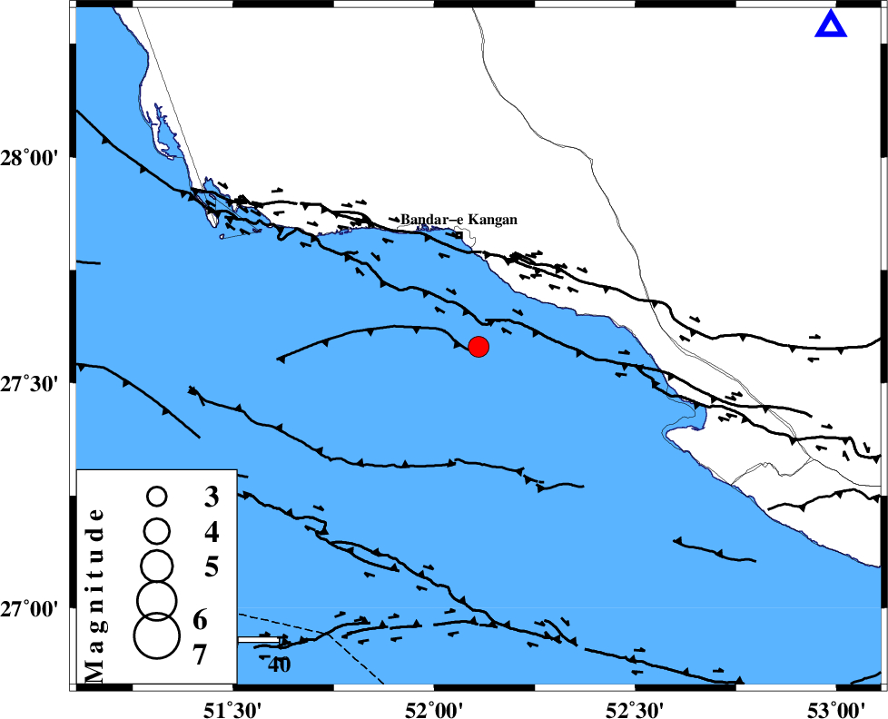
| Location | Lat:27.58 Lon: 52.11 |
| Region | Persian Gulf, 28 km South of Bandar-e kangan |
Nearest Cities |
|
| 25 km West of Bandar-e taheri, Bushehr Province | |
| 28 km South of Bandar-e kangan, Bushehr Province | |
| 35 km South West of Jam, Bushehr Province | |
| 50 km North West of Bandar-e asaluyeh, Bushehr Province | |
| 52 km South of Riz, Bushehr Province | |
| Depth | 15 km |
| Agency | |
Faults within 150 km: |
|
| MFF3 (Length: 292 km) , Distance to epicenter: 23 km | |
| BORAZJAN_F (Length: 168 km) , Distance to epicenter: 68 km | |
| MFF5 (Length: 74 km) , Distance to epicenter: 88 km | |
| Number of Phases | 5 |
| RMS | 0.1 |
| Number of Stations | 3 |
| Error in Latitude | >3.7 km |
| Error in Longitude | 1.5 km |
| Error in Depth | 5.2 km |
Download waveform in seisan format
to download seisan software Click here
to access information about IIEES stations Click here
Amplitude | ||||||||
| UID | Agency | Station | Component | Amplitude | Period | Arrival Time | Proccessing Time | Signal Clip |
| 89641 | IIEES | GHIR | E | 744.6 | 0.56 | 2013-06-14 21:53:03 | 2013-06-15 12:13:00 | n |
| 89642 | IIEES | GHIR | N | 613 | 0.56 | 2013-06-14 21:53:06 | 2013-06-15 12:13:00 | n |
| 89643 | IIEES | AHRM | N | 368.5 | 0.6 | 2013-06-14 21:53:21 | 2013-06-15 12:13:00 | n |
Phase | ||||||||||||
| Agency | Station | Component | Phase Type | Phase Quality | First Motion | Observed Arrival Time | Time Residual | Loc. Flag | Input Weight | Distance | Azimuth | |
| IIEES | GHIR | N | Pg | E | 2013-06-14 21:52:43 | -0.08 | y | 116 | 48 | |||
| IIEES | GHIR | E | Sg | E | 2013-06-14 21:52:57 | 0.05 | y | 116 | 48 | |||
| IIEES | AHRM | Z | Pg | E | 2013-06-14 21:52:50 | 0.08 | y | 163 | 331 | |||
| IIEES | AHRM | N | Sg | E | 2013-06-14 21:53:10 | -0.05 | y | 163 | 331 | |||
| IIEES | YZKH | Z | Pn | E | 2013-06-14 21:53:44 | 0 | y | 584 | 24 | |||