
Magnitude |
:3.1 |
| Date & Time (UTC) | 2012-12-23 08:58:30.0 |
| Date & Time (Local) | 1391/10/3 12:28:30.0 |
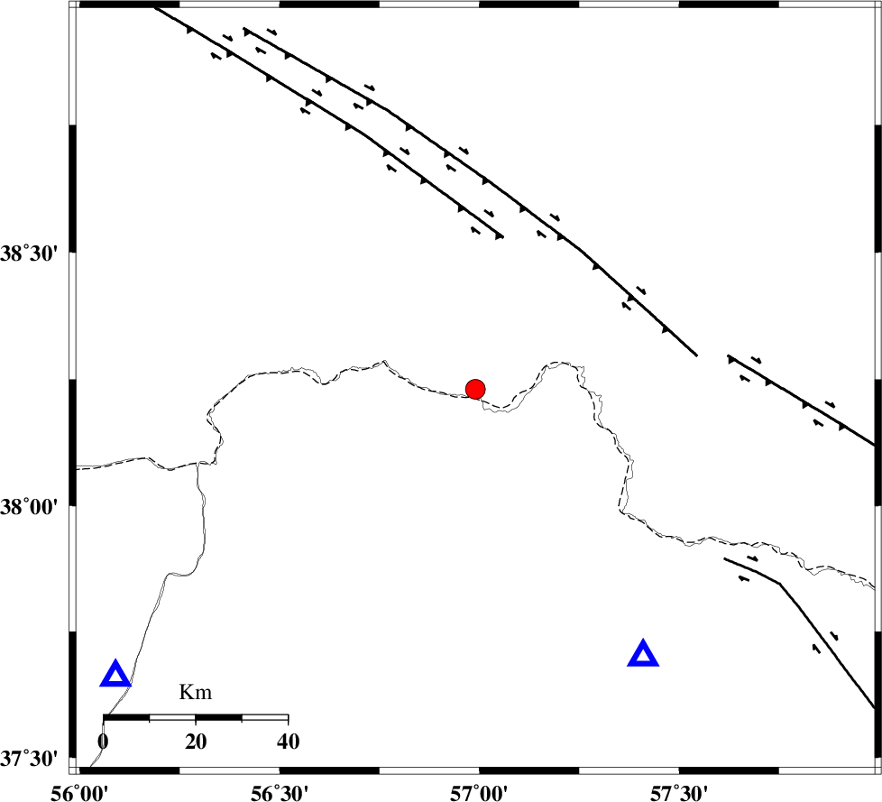
| Location | Lat:38.23 Lon: 56.99 |
| Region | 75 km North of Ashkhaneh |
Nearest Cities |
|
| 24 km North East of Yekehsoud-e paeen, Khorasan(north) Province | |
| 31 km North of Tangehzar, Khorasan(north) Province | |
| 35 km North West of Raz, Khorasan(north) Province | |
| 57 km North West of Gifan olia, Khorasan(north) Province | |
| 64 km North of Pish qaleh, Khorasan(north) Province | |
| Depth | 14 km |
| Agency | |
Faults within 150 km: |
|
| MAIN_KOPEHDAGH_F1 (Length: 318 km) , Distance to epicenter: 34 km | |
| MAIN_KOPEHDAGH_F2 (Length: 131 km) , Distance to epicenter: 38 km | |
| MAIN_KOPEHDAGH_F3 (Length: 96 km) , Distance to epicenter: 56 km | |
| Number of Phases | 7 |
| RMS | 0.1 |
| Number of Stations | 5 |
| Error in Latitude | >5.3 km |
| Error in Longitude | 3.3 km |
| Error in Depth | 6.7 km |
Download waveform in seisan format
to download seisan software Click here
to access information about IIEES stations Click here
Amplitude | ||||||||
| UID | Agency | Station | Component | Amplitude | Period | Arrival Time | Proccessing Time | Signal Clip |
| 87403 | IIEES | BJRD | E | 928.6 | 0.49 | 2012-12-23 08:58:56 | 2012-12-23 10:57:00 | n |
Phase | ||||||||||||
| Agency | Station | Component | Phase Type | Phase Quality | First Motion | Observed Arrival Time | Time Residual | Loc. Flag | Input Weight | Distance | Azimuth | |
| IIEES | BJRD | Z | Pg | E | 2012-12-23 08:58:41 | -0.23 | y | 69.1 | 147 | |||
| IIEES | BJRD | E | Sg | E | 2012-12-23 08:58:51 | 0.15 | y | 69.1 | 147 | |||
| IIEES | SHRO | Z | Pn | E | 2012-12-23 08:59:10 | 0.16 | y | 261 | 200 | |||
| IIEES | SHRO | E | Sg | E | 2012-12-23 08:59:43 | -0.1 | y | 261 | 200 | |||
| IIEES | TABS | Z | Pn | E | 2012-12-23 08:59:40 | 0.1 | y | 508 | 179 | |||
| IIEES | SHRT | Z | Pn | E | 2012-12-23 08:59:50 | -0.12 | y | 589 | 149 | |||
| IIEES | YZKH | Z | Pn | E | 2012-12-23 09:00:02 | 0.05 | y | 683 | 199 | |||