
Magnitude |
:2.9 |
| Date & Time (UTC) | 2012-12-15 21:57:45.4 |
| Date & Time (Local) | 1391/9/26 01:27:45.4 |
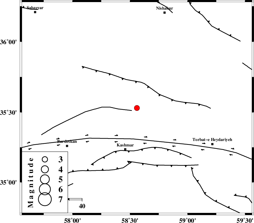
| Location | Lat:35.53 Lon: 58.56 |
| Region | Khorasan(center) Province, 34 km North of Kashmar |
Nearest Cities |
|
| 12 km North East of Rivash, Khorasan(center) Province | |
| 16 km North East of Toroq, Khorasan(center) Province | |
| 23 km East of Ondar, Khorasan(center) Province | |
| 30 km West of Kadkan, Khorasan(center) Province | |
| 33 km North East of Kasrineh, Khorasan(center) Province | |
| Depth | 15 km |
| Agency | |
Faults within 150 km: |
|
| BIJVARD_F (Length: 83 km) , Distance to epicenter: 4 km | |
| BALHAR_F (Length: 117 km) , Distance to epicenter: 19 km | |
| DORUNEH_F (Length: 713 km) , Distance to epicenter: 25 km | |
| Number of Phases | 4 |
| RMS | 0.3 |
| Number of Stations | 4 |
| Error in Latitude | >3.7 km |
| Error in Longitude | 3 km |
| Error in Depth | 0 km |
Download waveform in seisan format
to download seisan software Click here
to access information about IIEES stations Click here
Amplitude | ||||||||
| UID | Agency | Station | Component | Amplitude | Period | Arrival Time | Proccessing Time | Signal Clip |
| 87353 | IIEES | TABS | N | 48 | 0.48 | 2012-12-15 21:59:07 | 2012-12-16 04:31:00 | n |
| 87354 | IIEES | SHRT | N | 75.3 | 0.4 | 2012-12-15 21:59:02 | 2012-12-16 04:31:00 | n |
| 87355 | IIEES | SHRT | E | 72.9 | 0.4 | 2012-12-15 21:59:00 | 2012-12-16 04:31:00 | n |
Phase | ||||||||||||
| Agency | Station | Component | Phase Type | Phase Quality | First Motion | Observed Arrival Time | Time Residual | Loc. Flag | Input Weight | Distance | Azimuth | |
| IIEES | SHRO | Z | Pn | E | 2012-12-15 21:58:22 | -0.36 | y | 236 | 284 | |||
| IIEES | TABS | Z | Pn | E | 2012-12-15 21:58:24 | 0.3 | y | 247 | 213 | |||
| IIEES | BJRD | Z | Pn | E | 2012-12-15 21:58:25 | 0.23 | y | 262 | 337 | |||
| IIEES | SHRT | Z | Pn | E | 2012-12-15 21:58:25 | -0.17 | y | 262 | 142 | |||