
Magnitude |
:2.4 |
| Date & Time (UTC) | 2012-11-30 21:35:02.4 |
| Date & Time (Local) | 1391/9/11 01:05:02.4 |
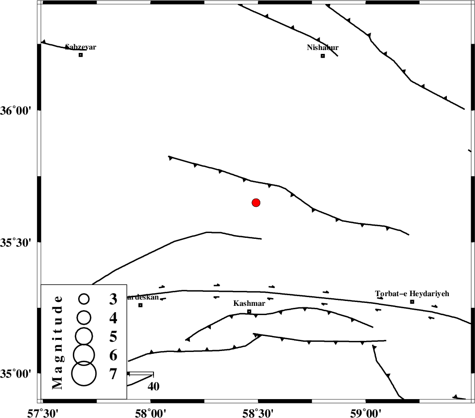
| Location | Lat:35.65 Lon: 58.49 |
| Region | Khorasan(center) Province, 46 km North of Kashmar |
Nearest Cities |
|
| 16 km North East of Ondar, Khorasan(center) Province | |
| 21 km North of Rivash, Khorasan(center) Province | |
| 21 km North of Toroq, Khorasan(center) Province | |
| 32 km East of Ghaleh meidan, Khorasan(center) Province | |
| 35 km South West of Golbu-ye sofla, Khorasan(center) Province | |
| Depth | 14 km |
| Agency | |
Faults within 150 km: |
|
| BALHAR_F (Length: 117 km) , Distance to epicenter: 9 km | |
| BIJVARD_F (Length: 83 km) , Distance to epicenter: 15 km | |
| DORUNEH_F (Length: 713 km) , Distance to epicenter: 38 km | |
| Number of Phases | 6 |
| RMS | 0.2 |
| Number of Stations | 3 |
| Error in Latitude | >3.5 km |
| Error in Longitude | 3.2 km |
| Error in Depth | 6.4 km |
Download waveform in seisan format
to download seisan software Click here
to access information about IIEES stations Click here
Amplitude | ||||||||
| UID | Agency | Station | Component | Amplitude | Period | Arrival Time | Proccessing Time | Signal Clip |
| 87218 | IIEES | TABS | N | 24.8 | 0.48 | 2012-11-30 21:36:18 | 2012-11-30 01:54:00 | n |
| 87219 | IIEES | TABS | E | 17.2 | 0.36 | 2012-11-30 21:36:19 | 2012-11-30 01:54:00 | n |
| 87220 | IIEES | SHRT | N | 16.9 | 0.52 | 2012-11-30 21:36:28 | 2012-11-30 01:54:00 | n |
| 87221 | IIEES | SHRT | E | 14.2 | 0.4 | 2012-11-30 21:36:28 | 2012-11-30 01:54:00 | n |
Phase | ||||||||||||
| Agency | Station | Component | Phase Type | Phase Quality | First Motion | Observed Arrival Time | Time Residual | Loc. Flag | Input Weight | Distance | Azimuth | |
| IIEES | SHRO | Z | Pn | E | 2012-11-30 21:35:38 | -0.09 | y | 227 | 281 | |||
| IIEES | SHRO | E | Sg | E | 2012-11-30 21:36:06 | -0.09 | y | 227 | 281 | |||
| IIEES | TABS | Z | Pn | E | 2012-11-30 21:35:41 | 0 | y | 255 | 210 | |||
| IIEES | TABS | E | Sg | E | 2012-11-30 21:36:14 | 0.1 | y | 255 | 210 | |||
| IIEES | SHRT | Z | Pn | E | 2012-11-30 21:35:44 | 0.43 | y | 277 | 143 | |||
| IIEES | SHRT | N | Sg | E | 2012-11-30 21:36:20 | -0.33 | y | 277 | 143 | |||