
Magnitude |
:3.4 |
| Date & Time (UTC) | 2011-02-13 09:30:58.1 |
| Date & Time (Local) | 1389/11/24 13:00:58.1 |
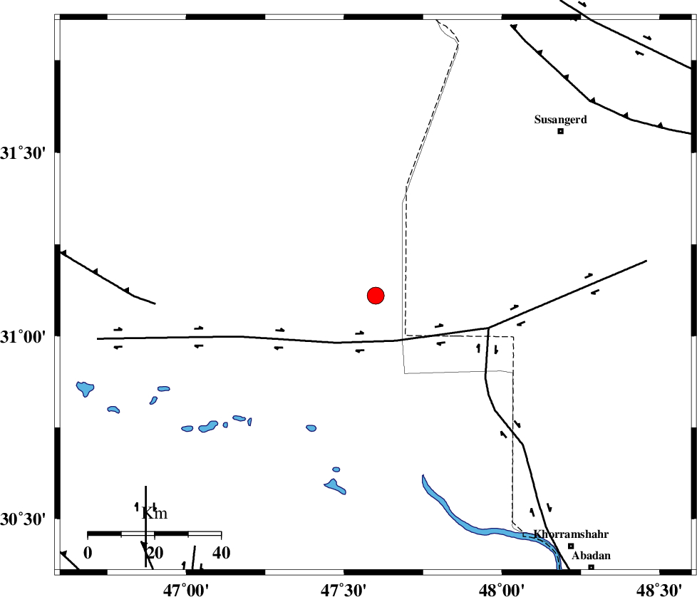
| Location | Lat:31.11 Lon: 47.6 |
| Region | Iraq, 69 km North-West of Al Basrah |
Nearest Cities |
|
| 60 km South West of Hoveizeh, Khoozestan Province | |
| 68 km North West of Al Basrah, Iraq Province | |
| 75 km South West of Susangerd, Khoozestan Province | |
| 77 km South West of Bostan, Khoozestan Province | |
| 79 km South West of Jalaliyeh, Khoozestan Province | |
| Depth | 24 km |
| Agency | |
Faults within 150 km: |
|
| AHVAZ_F (Length: 99 km) , Distance to epicenter: 84 km | |
| Number of Phases | 8 |
| RMS | 0.2 |
| Number of Stations | 7 |
| Error in Latitude | >8.2 km |
| Error in Longitude | 7.4 km |
| Error in Depth | 8.5 km |
Download waveform in seisan format
to download seisan software Click here
to access information about IIEES stations Click here
Amplitude | ||||||||
| UID | Agency | Station | Component | Amplitude | Period | Arrival Time | Proccessing Time | Signal Clip |
| 77914 | IIEES | SHGR | E | 864.5 | 0.37 | 2011-02-13 09:31:50 | 2011-02-13 09:47:00 | n |
| 77915 | IIEES | SHGR | N | 801.2 | 0.47 | 2011-02-13 09:31:51 | 2011-02-13 09:47:00 | n |
| 77916 | IIEES | KHMZ | N | 51.4 | 0.44 | 2011-02-13 09:32:45 | 2011-02-13 09:47:00 | n |
| 77917 | IIEES | KHMZ | E | 52.1 | 0.48 | 2011-02-13 09:32:49 | 2011-02-13 09:47:00 | n |
| 77918 | IIEES | GHVR | N | 33.6 | 0.51 | 2011-02-13 09:33:12 | 2011-02-13 09:47:00 | n |
Phase | ||||||||||||
| Agency | Station | Component | Phase Type | Phase Quality | First Motion | Observed Arrival Time | Time Residual | Loc. Flag | Input Weight | Distance | Azimuth | |
| IIEES | SHGR | Z | Pg | E | 2011-02-13 09:31:24 | 0.1 | y | 159 | 46 | |||
| IIEES | SHGR | N | Sg | E | 2011-02-13 09:31:42 | -0.1 | y | 159 | 46 | |||
| IIEES | KHMZ | Z | Pn | E | 2011-02-13 09:31:50 | 0.1 | y | 367 | 37 | |||
| IIEES | SNGE | Z | Pn | E | 2011-02-13 09:31:59 | -0.2 | y | 442 | 357 | |||
| IIEES | ASAO | Z | Pn | E | 2011-02-13 09:32:00 | 0.1 | y | 444 | 30 | |||
| IIEES | GHVR | Z | Pn | E | 2011-02-13 09:32:07 | 0.2 | y | 506 | 41 | |||
| IIEES | NASN | Z | Pn | E | 2011-02-13 09:32:10 | -0.3 | y | 527 | 68 | |||
| IIEES | DAMV | Z | Pn | E | 2011-02-13 09:32:25 | 0.2 | y | 646 | 38 | |||