
Magnitude |
:3.3 |
| Date & Time (UTC) | 2011-01-29 19:43:47.1 |
| Date & Time (Local) | 1389/11/9 23:13:47.1 |
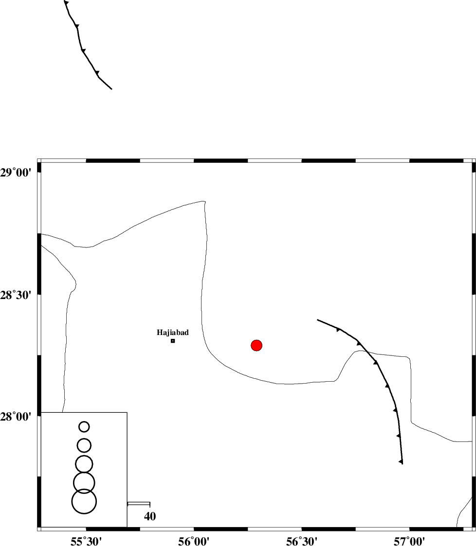
| Location | Lat:28.29 Lon: 56.29 |
| Region | Kerman Province, 38 km East of Hajiabad |
Nearest Cities |
|
| 18 km South of Arzuieeh, Kerman Province | |
| 21 km South of Shahmaran, Kerman Province | |
| 31 km North of Fareqan, Hormozgan Province | |
| 38 km East of Hajiabad, Hormozgan Province | |
| 58 km West of Sarkhan, Kerman Province | |
| Depth | 15 km |
| Agency | |
Faults within 150 km: |
|
| MAIN_ZAGROS_R_F (Length: 1106 km) , Distance to epicenter: 8 km | |
| HZF2 (Length: 437 km) , Distance to epicenter: 41 km | |
| ZENDAN_MINAB_F_Z1 (Length: 183 km) , Distance to epicenter: 97 km | |
| Number of Phases | 3 |
| RMS | 0 |
| Number of Stations | 3 |
| Error in Latitude | >1.6 km |
| Error in Longitude | 4.7 km |
| Error in Depth | 0 km |
Download waveform in seisan format
to download seisan software Click here
to access information about IIEES stations Click here
Amplitude | ||||||||
| UID | Agency | Station | Component | Amplitude | Period | Arrival Time | Proccessing Time | Signal Clip |
| 77656 | IIEES | BNDS | N | 1136.9 | 0 | 2011-01-29 19:44:21 | 2011-01-29 07:53:00 | n |
| 77657 | IIEES | BNDS | E | 1040.6 | 1.04 | 2011-01-29 19:44:22 | 2011-01-29 07:53:00 | n |
| 77658 | IIEES | KRBR | N | 319.9 | 0.35 | 2011-01-29 19:44:48 | 2011-01-29 07:53:00 | n |
Phase | ||||||||||||
| Agency | Station | Component | Phase Type | Phase Quality | First Motion | Observed Arrival Time | Time Residual | Loc. Flag | Input Weight | Distance | Azimuth | |
| IIEES | BNDS | Z | Pg | E | 2011-01-29 19:44:04 | 0 | y | 99.5 | 186 | |||
| IIEES | KRBR | Z | Pg | E | 2011-01-29 19:44:19 | 0 | y | 193 | 14 | |||
| IIEES | ZHSF | Z | Pn | E | 2011-01-29 19:44:52 | 0 | y | 462 | 70 | |||