
Magnitude |
:2.8 |
| Date & Time (UTC) | 2010-10-13 03:05:48.9 |
| Date & Time (Local) | 1389/7/21 06:35:48.9 |
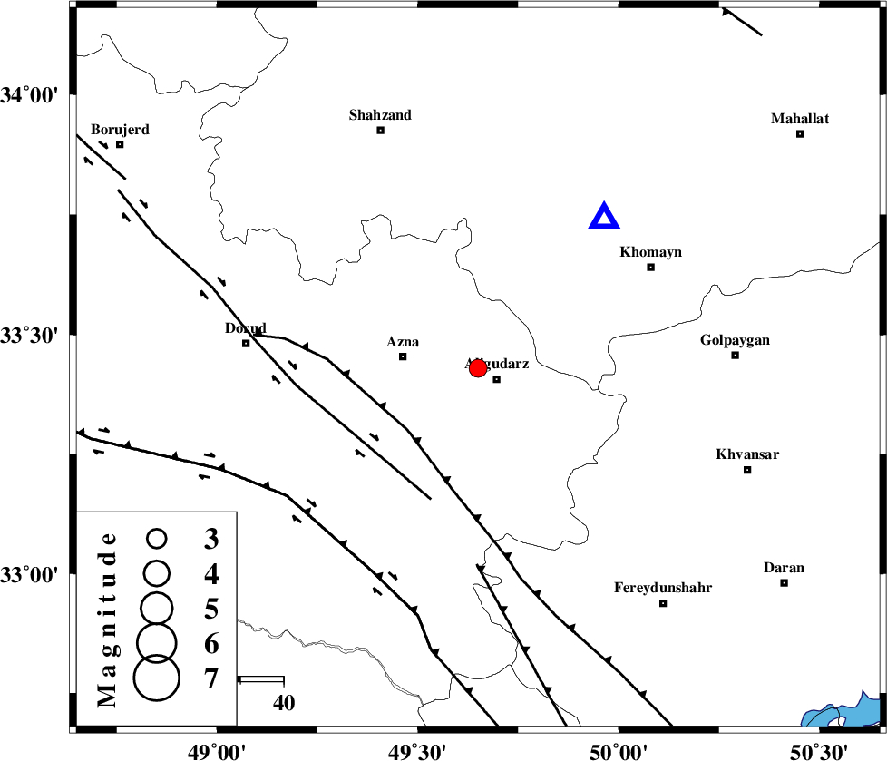
| Location | Lat:33.43 Lon: 49.65 |
| Region | Lorestan Province, 5 km Aligudarz |
Nearest Cities |
|
| 5 km North of Aligudarz, Lorestan Province | |
| 6 km North of Sur, Lorestan Province | |
| 7 km of Khameh sofla, Lorestan Province | |
| 18 km East of Azna, Lorestan Province | |
| 21 km North of Shapoorabad, Lorestan Province | |
| Depth | 6 km |
| Agency | |
Faults within 150 km: |
|
| MAIN_ZAGROS_R_F (Length: 1106 km) , Distance to epicenter: 22 km | |
| DORUD (Length: 100 km) , Distance to epicenter: 32 km | |
| ARDAL_F (Length: 170 km) , Distance to epicenter: 46 km | |
| Number of Phases | 5 |
| RMS | 0.2 |
| Number of Stations | 4 |
| Error in Latitude | >5.3 km |
| Error in Longitude | 4.6 km |
| Error in Depth | 9.5 km |
Download waveform in seisan format
to download seisan software Click here
to access information about IIEES stations Click here
Amplitude | ||||||||
| UID | Agency | Station | Component | Amplitude | Period | Arrival Time | Proccessing Time | Signal Clip |
| 71770 | IIEES | KHMZ | N | 935.7 | 0.62 | 2010-10-13 03:06:04 | 2010-10-13 03:35:00 | n |
| 71771 | IIEES | KHMZ | E | 885.3 | 0.49 | 2010-10-13 03:06:04 | 2010-10-13 03:35:00 | n |
| 71772 | IIEES | GHVR | E | 75.5 | 0.12 | 2010-10-13 03:06:50 | 2010-10-13 03:35:00 | n |
Phase | ||||||||||||
| Agency | Station | Component | Phase Type | Phase Quality | First Motion | Observed Arrival Time | Time Residual | Loc. Flag | Input Weight | Distance | Azimuth | |
| IIEES | KHMZ | Z | Pg | E | 2010-10-13 03:05:56 | -0.2 | y | 45 | 41 | |||
| IIEES | KHMZ | E | Sg | E | 2010-10-13 03:06:03 | 0.2 | y | 45 | 41 | |||
| IIEES | GHVR | Z | Pg | E | 2010-10-13 03:06:21 | -0.1 | y | 188 | 51 | |||
| IIEES | SNGE | Z | Pn | E | 2010-10-13 03:06:32 | 0.1 | y | 281 | 312 | |||
| IIEES | NASN | Z | Pn | E | 2010-10-13 03:06:35 | 0.1 | y | 303 | 103 | |||