
Magnitude |
:3 |
| Date & Time (UTC) | 2010-10-10 12:59:54.0 |
| Date & Time (Local) | 1389/7/18 16:29:54.0 |
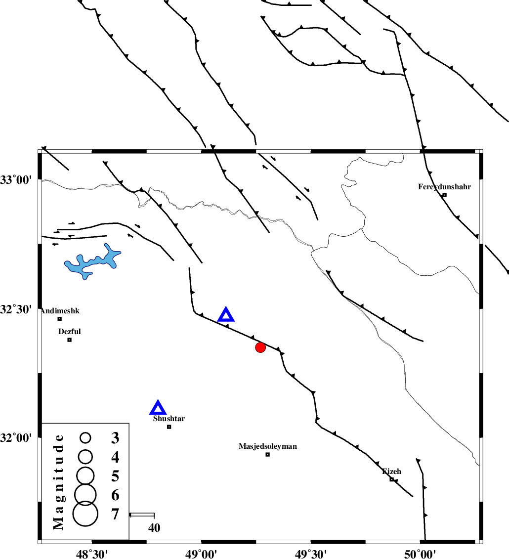
| Location | Lat:32.35 Lon: 49.27 |
| Region | Khoozestan Province, 16 km East of Lali |
Nearest Cities |
|
| 16 km East of Lali, Khoozestan Province | |
| 16 km North East of Jaefarabad, Khoozestan Province | |
| 23 km North West of Qale-yekhvaju, Khoozestan Province | |
| 28 km North West of Paabshalal, Khoozestan Province | |
| 31 km North East of Haft shahidan, Khoozestan Province | |
| Depth | 14 km |
| Agency | |
Faults within 150 km: |
|
| MFF2 (Length: 205 km) , Distance to epicenter: 7 km | |
| DEZFUL_EMBAYMENT (Length: 228 km) , Distance to epicenter: 31 km | |
| BALARUD_F_Z2 (Length: 58 km) , Distance to epicenter: 53 km | |
| Number of Phases | 6 |
| RMS | 0.1 |
| Number of Stations | 5 |
| Error in Latitude | >2.5 km |
| Error in Longitude | 2.7 km |
| Error in Depth | 3.8 km |
Download waveform in seisan format
to download seisan software Click here
to access information about IIEES stations Click here
Amplitude | ||||||||
| UID | Agency | Station | Component | Amplitude | Period | Arrival Time | Proccessing Time | Signal Clip |
| 71690 | IIEES | SHGR | N | 1507.9 | 0.8 | 2010-10-10 13:00:14 | 2010-10-10 01:35:00 | n |
| 71691 | IIEES | SHGR | E | 1383.1 | 0.52 | 2010-10-10 13:00:18 | 2010-10-10 01:35:00 | n |
| 71692 | IIEES | GHVR | E | 52 | 0.88 | 2010-10-10 13:01:22 | 2010-10-10 01:35:00 | n |
| 71693 | IIEES | GHVR | N | 39.1 | 0.72 | 2010-10-10 13:01:24 | 2010-10-10 01:35:00 | n |
| 71694 | IIEES | SNGE | N | 28.2 | 0.44 | 2010-10-10 13:01:43 | 2010-10-10 01:35:00 | n |
Phase | ||||||||||||
| Agency | Station | Component | Phase Type | Phase Quality | First Motion | Observed Arrival Time | Time Residual | Loc. Flag | Input Weight | Distance | Azimuth | |
| IIEES | SHGR | Z | Pg | E | 2010-10-10 13:00:03 | 0 | y | 51.7 | 239 | |||
| IIEES | KHMZ | Z | P | E | 2010-10-10 13:00:21 | -0.2 | y | 167 | 23 | |||
| IIEES | GHVR | Z | P | E | 2010-10-10 13:00:38 | 0.1 | y | 299 | 37 | |||
| IIEES | GHVR | E | Sg | E | 2010-10-10 13:01:18 | 0.1 | y | 299 | 37 | |||
| IIEES | NASN | Z | P | E | 2010-10-10 13:00:43 | 0 | y | 336 | 81 | |||
| IIEES | SNGE | Z | P | E | 2010-10-10 13:00:45 | 0 | y | 353 | 330 | |||