
Magnitude |
:3.4 |
| Date & Time (UTC) | 2010-08-11 14:09:47.5 |
| Date & Time (Local) | 1389/5/20 18:39:47.5 |
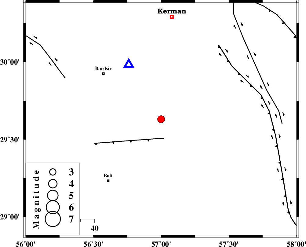
| Location | Lat:29.63 Lon: 57 |
| Region | Kerman Province, 53 km South-East of Bardsir |
Nearest Cities |
|
| 21 km North East of Lalehzar, Kerman Province | |
| 32 km South East of Negar, Kerman Province | |
| 33 km North of Siyah bonueyeh, Kerman Province | |
| 34 km North East of Ghale-ye asgar, Kerman Province | |
| 38 km North of Kahnuj, Kerman Province | |
| Depth | 5 km |
| Agency | |
Faults within 150 km: |
|
| LALEHZAR_F (Length: 52 km) , Distance to epicenter: 14 km | |
| GOWK_F (Length: 152 km) , Distance to epicenter: 63 km | |
| RAFSANJAN_F (Length: 129 km) , Distance to epicenter: 74 km | |
| Number of Phases | 5 |
| RMS | 0.1 |
| Number of Stations | 4 |
| Error in Latitude | >2.7 km |
| Error in Longitude | 6.2 km |
| Error in Depth | 5.5 km |
Download waveform in seisan format
to download seisan software Click here
to access information about IIEES stations Click here
Amplitude | ||||||||
| UID | Agency | Station | Component | Amplitude | Period | Arrival Time | Proccessing Time | Signal Clip |
| 68450 | IIEES | KRBR | N | 7963.9 | 0.24 | 2010-08-11 14:10:02 | 2010-08-11 02:29:00 | n |
| 68451 | IIEES | KRBR | E | 9863.3 | 0.24 | 2010-08-11 14:10:02 | 2010-08-11 02:29:00 | n |
| 68452 | IIEES | BNDS | E | 162.2 | 0.4 | 2010-08-11 14:11:06 | 2010-08-11 02:29:00 | n |
| 68453 | IIEES | BNDS | N | 130 | 0.44 | 2010-08-11 14:11:07 | 2010-08-11 02:29:00 | n |
| 68454 | IIEES | GHIR | E | 35.4 | 0.36 | 2010-08-11 14:11:47 | 2010-08-11 02:29:00 | n |
| 68455 | IIEES | GHIR | N | 34.8 | 0.48 | 2010-08-11 14:11:54 | 2010-08-11 02:29:00 | n |
| 68456 | IIEES | TABS | N | 36.9 | 0.88 | 2010-08-11 14:12:06 | 2010-08-11 02:29:00 | n |
Phase | ||||||||||||
| Agency | Station | Component | Phase Type | Phase Quality | First Motion | Observed Arrival Time | Time Residual | Loc. Flag | Input Weight | Distance | Azimuth | |
| IIEES | KRBR | Z | Pg | E | 2010-08-11 14:09:56 | 0.1 | y | 45.3 | 329 | |||
| IIEES | KRBR | E | Sg | E | 2010-08-11 14:10:02 | -0.1 | y | 45.3 | 329 | |||
| IIEES | BNDS | Z | P | E | 2010-08-11 14:10:28 | -0.1 | y | 260 | 198 | |||
| IIEES | GHIR | Z | P | E | 2010-08-11 14:10:48 | 0.1 | y | 419 | 250 | |||
| IIEES | TABS | Z | P | E | 2010-08-11 14:10:51 | 0 | y | 446 | 1 | |||