
Magnitude |
:3.1 |
| Date & Time (UTC) | 2010-07-24 14:57:10.7 |
| Date & Time (Local) | 1389/5/2 19:27:10.7 |
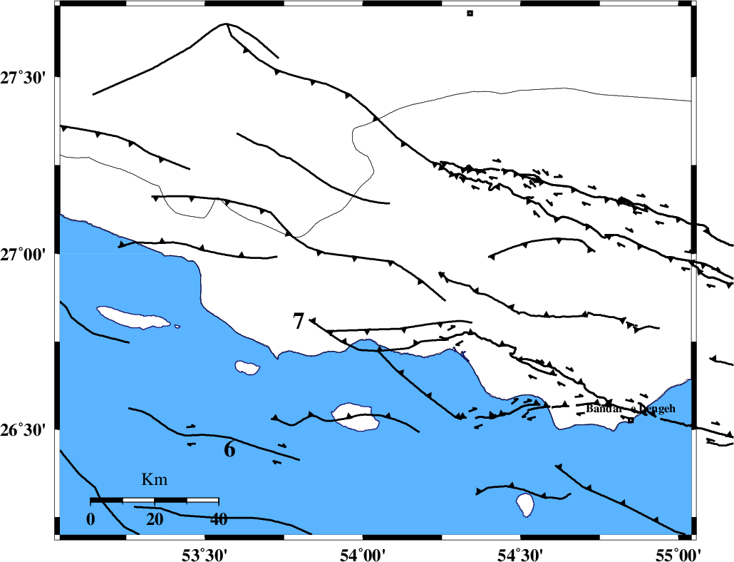
| Location | Lat:26.95 Lon: 54.04 |
| Region | Hormozgan Province, 42 km South-West of Bastak |
Nearest Cities |
|
| 25 km West of Jenah, Hormozgan Province | |
| 39 km South East of Ahl, Fars Province | |
| 42 km South West of Bastak, Hormozgan Province | |
| 52 km South East of Ashkenan, Fars Province | |
| 61 km South of Bagh, Fars Province | |
| Depth | 14 km |
| Agency | |
Faults within 150 km: |
|
| MFF3 (Length: 292 km) , Distance to epicenter: 5 km | |
| MFF1 (Length: 180 km) , Distance to epicenter: 14 km | |
| ZFF1 (Length: 165 km) , Distance to epicenter: 22 km | |
| Number of Phases | 4 |
| RMS | 0.1 |
| Number of Stations | 3 |
| Error in Latitude | >11.8 km |
| Error in Longitude | 7.6 km |
| Error in Depth | 7.6 km |
Download waveform in seisan format
to download seisan software Click here
to access information about IIEES stations Click here
Amplitude | ||||||||
| UID | Agency | Station | Component | Amplitude | Period | Arrival Time | Proccessing Time | Signal Clip |
| 66654 | IIEES | GHIR | N | 205.2 | 1.02 | 2010-07-24 14:58:05 | 2010-07-25 03:11:00 | n |
| 66655 | IIEES | GHIR | E | 160.9 | 1.19 | 2010-07-24 14:58:06 | 2010-07-25 03:11:00 | n |
| 66656 | IIEES | BNDS | E | 112.4 | 0.34 | 2010-07-24 14:58:20 | 2010-07-25 03:11:00 | n |
| 66657 | IIEES | BNDS | N | 136.2 | 0.14 | 2010-07-24 14:58:20 | 2010-07-25 03:11:00 | n |
| 66658 | IIEES | KRBR | N | 34.9 | 0.89 | 2010-07-24 14:59:21 | 2010-07-25 03:11:00 | n |
| 66659 | IIEES | KRBR | E | 29 | 1.47 | 2010-07-24 14:59:25 | 2010-07-25 03:11:00 | n |
Phase | ||||||||||||
| Agency | Station | Component | Phase Type | Phase Quality | First Motion | Observed Arrival Time | Time Residual | Loc. Flag | Input Weight | Distance | Azimuth | |
| IIEES | GHIR | Z | Pg | E | 2010-07-24 14:57:40 | 0 | y | 181 | 325 | |||
| IIEES | GHIR | N | Sg | E | 2010-07-24 14:58:02 | -0.1 | y | 181 | 325 | |||
| IIEES | BNDS | Z | Pg | E | 2010-07-24 14:57:46 | -0.1 | y | 217 | 76 | |||
| IIEES | KRBR | Z | Pn | E | 2010-07-24 14:58:12 | 0.2 | y | 429 | 38 | |||