
Magnitude |
:3.7 |
| Date & Time (UTC) | 2010-07-20 20:24:52.4 |
| Date & Time (Local) | 1389/4/30 00:54:52.4 |
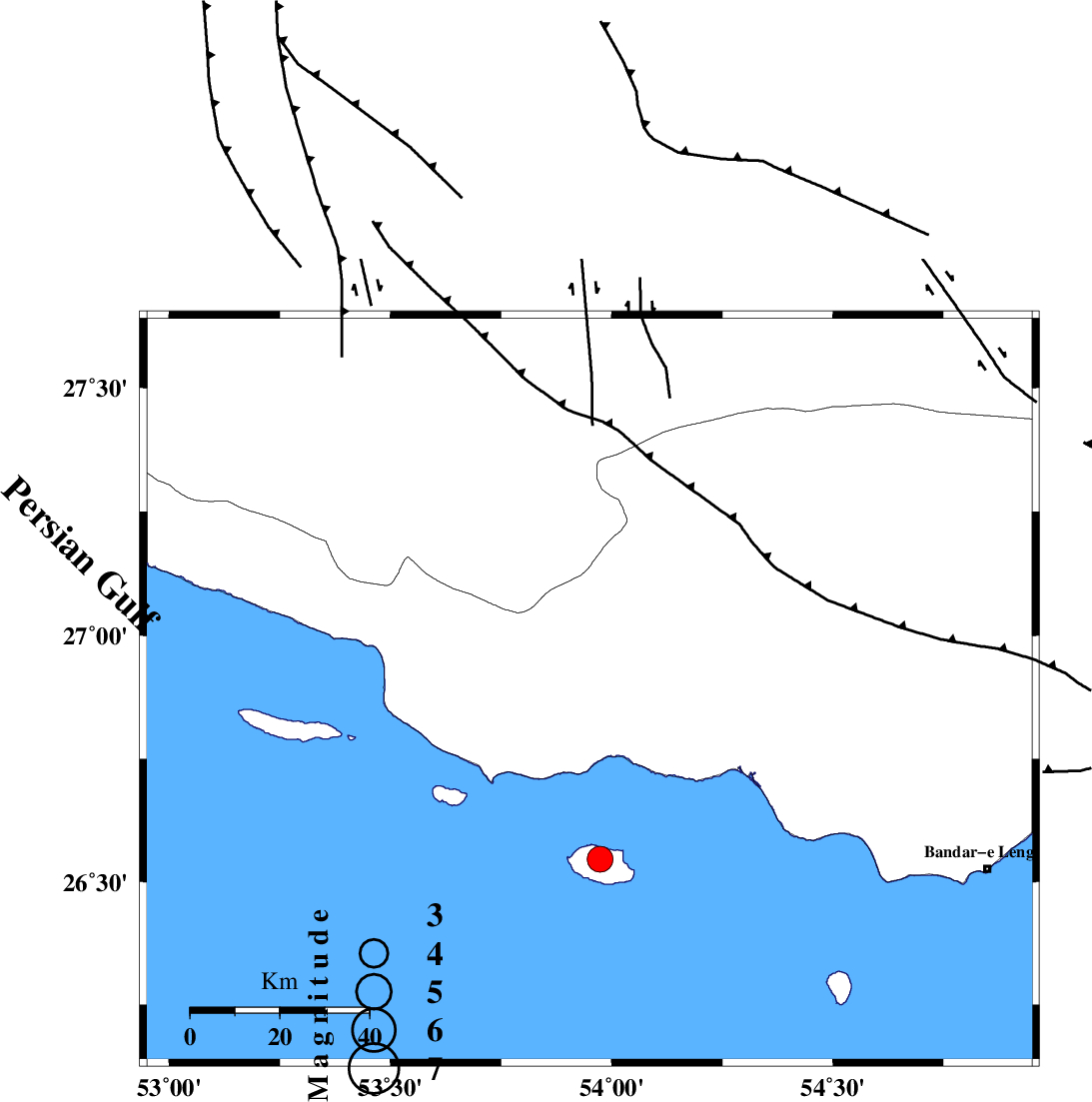
| Location | Lat:26.89 Lon: 53.95 |
| Region | Hormozgan Province, 53 km South-West of Bastak |
Nearest Cities |
|
| 36 km South West of Jenah, Hormozgan Province | |
| 38 km South East of Ahl, Fars Province | |
| 50 km South East of Ashkenan, Fars Province | |
| 53 km South West of Bastak, Hormozgan Province | |
| 68 km South of Bagh, Fars Province | |
| Depth | 18 km |
| Agency | |
Faults within 150 km: |
|
| MFF3 (Length: 292 km) , Distance to epicenter: 6 km | |
| ZFF1 (Length: 165 km) , Distance to epicenter: 16 km | |
| MFF1 (Length: 180 km) , Distance to epicenter: 23 km | |
| Number of Phases | 4 |
| RMS | 0 |
| Number of Stations | 3 |
| Error in Latitude | >9.7 km |
| Error in Longitude | 4.6 km |
| Error in Depth | 10.6 km |
Download waveform in seisan format
to download seisan software Click here
to access information about IIEES stations Click here
Amplitude | ||||||||
| UID | Agency | Station | Component | Amplitude | Period | Arrival Time | Proccessing Time | Signal Clip |
| 66130 | IIEES | GHIR | E | 1255.6 | 0.48 | 2010-07-20 20:25:47 | 2010-07-20 09:37:00 | n |
| 66131 | IIEES | GHIR | N | 1124.8 | 0.44 | 2010-07-20 20:25:51 | 2010-07-20 09:37:00 | n |
| 66132 | IIEES | BNDS | E | 269 | 0.52 | 2010-07-20 20:26:10 | 2010-07-20 09:37:00 | n |
| 66133 | IIEES | BNDS | N | 413.7 | 0.48 | 2010-07-20 20:26:14 | 2010-07-20 09:37:00 | n |
| 66134 | IIEES | KRBR | N | 87.2 | 0.48 | 2010-07-20 20:26:58 | 2010-07-20 09:37:00 | n |
| 66135 | IIEES | KRBR | E | 100.6 | 0.56 | 2010-07-20 20:27:07 | 2010-07-20 09:37:00 | n |
Phase | ||||||||||||
| Agency | Station | Component | Phase Type | Phase Quality | First Motion | Observed Arrival Time | Time Residual | Loc. Flag | Input Weight | Distance | Azimuth | |
| IIEES | GHIR | N | Pn | E | 2010-07-20 20:25:22 | 0 | y | 181 | 329 | |||
| IIEES | GHIR | N | Sg | E | 2010-07-20 20:25:44 | 0 | y | 181 | 329 | |||
| IIEES | BNDS | Z | Pn | E | 2010-07-20 20:25:28 | 0 | y | 227 | 75 | |||
| IIEES | KRBR | Z | Pn | E | 2010-07-20 20:25:54 | 0 | y | 439 | 38 | |||