
Magnitude |
:4.1 |
| Date & Time (UTC) | 2008-11-11 13:51:01.1 |
| Date & Time (Local) | 1387/8/21 17:21:01.1 |
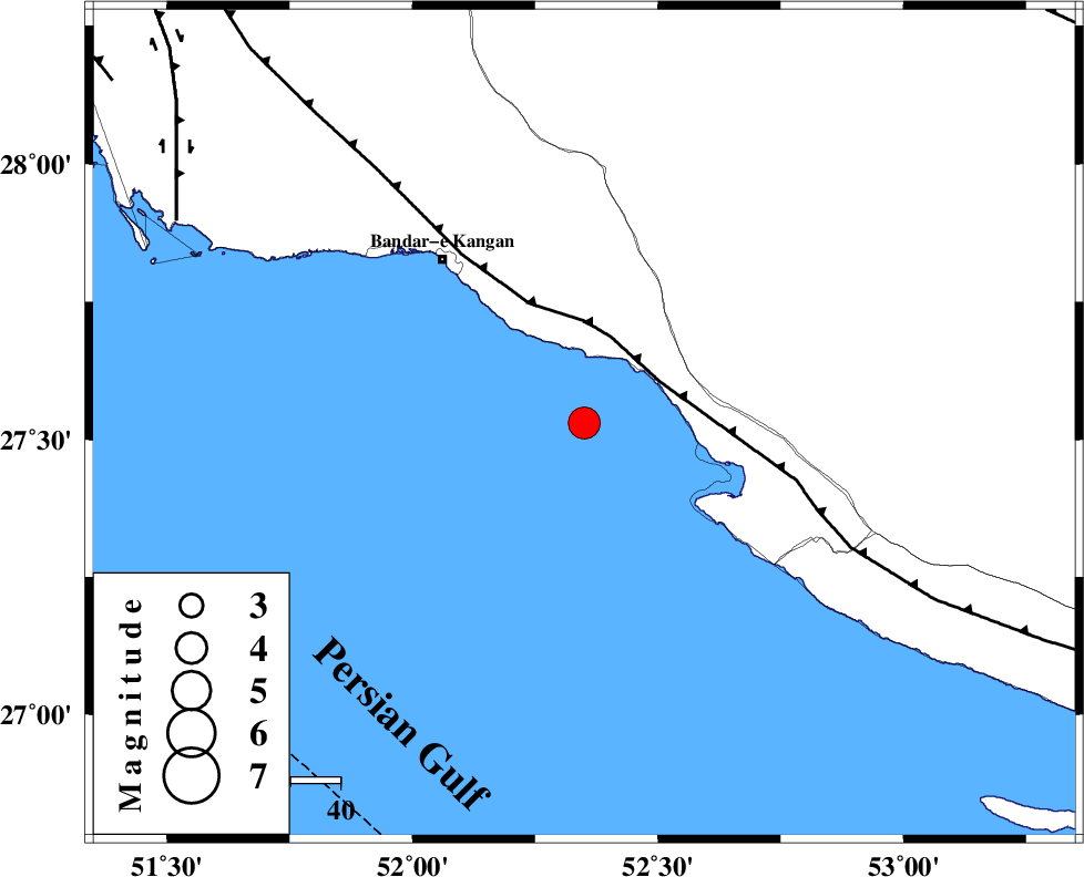
| Location | Lat:27.53 Lon: 52.35 |
| Region | Persian Gulf, 34 km South of Jam |
Nearest Cities |
|
| 15 km South of Bandar-e taheri, Bushehr Province | |
| 26 km North West of Bandar-e asaluyeh, Bushehr Province | |
| 34 km South of Jam, Bushehr Province | |
| 35 km South West of Gallehdar, Fars Province | |
| 39 km South West of Asir, Fars Province | |
| Depth | 15 km |
| Agency | |
Faults within 150 km: |
|
| MFF3 (Length: 292 km) , Distance to epicenter: 17 km | |
| BORAZJAN_F (Length: 168 km) , Distance to epicenter: 91 km | |
| MFF5 (Length: 74 km) , Distance to epicenter: 101 km | |
| Number of Phases | 6 |
| RMS | 0.4 |
| Number of Stations | 6 |
| Error in Latitude | >15.1 km |
| Error in Longitude | 3.9 km |
| Error in Depth | 0 km |
Download waveform in seisan format
to download seisan software Click here
to access information about IIEES stations Click here
Amplitude | ||||||||
| UID | Agency | Station | Component | Amplitude | Period | Arrival Time | Proccessing Time | Signal Clip |
| 51141 | IIEES | BNDS | N | 362.2 | 0.46 | 2008-11-11 13:53:03 | 2009-05-17 10:07:00 | n |
| 51142 | IIEES | BNDS | E | 376.1 | 0.71 | 2008-11-11 13:53:07 | 2009-05-17 10:07:00 | n |
| 51143 | IIEES | KRBR | E | 161.2 | 0.45 | 2008-11-11 13:53:08 | 2009-05-17 10:07:00 | n |
Phase | ||||||||||||
| Agency | Station | Component | Phase Type | Phase Quality | First Motion | Observed Arrival Time | Time Residual | Loc. Flag | Input Weight | Distance | Azimuth | |
| IIEES | BNDS | Z | Pn | E | 2008-11-11 13:51:55 | -0.2 | y | 378 | 91 | |||
| IIEES | KRBR | Z | PN5 | E | 2008-11-11 13:52:12 | 0.6 | y | 509 | 57 | |||
| IIEES | NASN | Z | Pn | E | 2008-11-11 13:52:21 | -0.2 | y | 586 | 4 | |||
| IIEES | ASAO | Z | Pn | E | 2008-11-11 13:52:49 | -0.1 | y | 809 | 345 | |||
| IIEES | TABS | Z | Pn | E | 2008-11-11 13:52:49 | -0.6 | y | 818 | 33 | |||
| IIEES | SNGE | Z | Pn | E | 2008-11-11 13:53:09 | 0.5 | y | 964 | 332 | |||