
Magnitude |
:3.5 |
| Date & Time (UTC) | 2008-09-20 07:02:27.7 |
| Date & Time (Local) | 1387/6/30 11:32:27.7 |
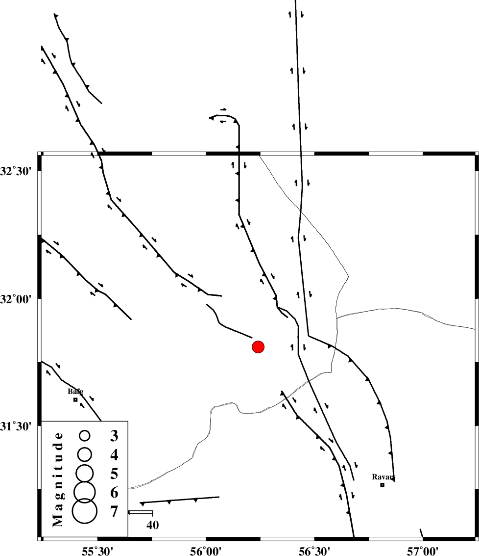
| Location | Lat:31.81 Lon: 56.24 |
| Region | 81 km North-West of Ravar, Kerman Province |
Nearest Cities |
|
| 16 km North of Asfih, Yazd Province | |
| 17 km North East of Benestan, Yazd Province | |
| 21 km East of Behabad, Yazd Province | |
| 44 km North East of Kushk, Yazd Province | |
| 44 km North of Kuhbanan, Kerman Province | |
| Depth | 15 km |
| Agency | |
Faults within 150 km: |
|
| JAFARABAD_F (Length: 60 km) , Distance to epicenter: 7 km | |
| KUHBANAN_F (Length: 189 km) , Distance to epicenter: 22 km | |
| SARBALA_F (Length: 92 km) , Distance to epicenter: 52 km | |
| Number of Phases | 6 |
| RMS | 0.5 |
| Number of Stations | 4 |
| Error in Latitude | >3.8 km |
| Error in Longitude | 12.5 km |
| Error in Depth | 15.7 km |
Download waveform in seisan format
to download seisan software Click here
to access information about IIEES stations Click here
Amplitude | ||||||||
| UID | Agency | Station | Component | Amplitude | Period | Arrival Time | Proccessing Time | Signal Clip |
| 50494 | IIEES | KRBR | N | 829.5 | 0.51 | 2008-09-20 07:03:30 | 2009-05-05 01:27:00 | n |
| 50495 | IIEES | NASN | N | 62 | 0.63 | 2008-09-20 07:04:05 | 2009-05-05 01:27:00 | n |
Phase | ||||||||||||
| Agency | Station | Component | Phase Type | Phase Quality | First Motion | Observed Arrival Time | Time Residual | Loc. Flag | Input Weight | Distance | Azimuth | |
| IIEES | KRBR | Z | Pg | E | 2008-09-20 07:03:01 | -0.7 | y | 209 | 166 | |||
| IIEES | KRBR | E | Sg | E | 2008-09-20 07:03:27 | 0.7 | y | 209 | 166 | |||
| IIEES | TABS | Z | Pg | E | 2008-09-20 07:03:03 | -0.1 | y | 220 | 22 | |||
| IIEES | TABS | E | Sg | E | 2008-09-20 07:03:30 | 0.5 | y | 220 | 22 | |||
| IIEES | NASN | Z | Pn | E | 2008-09-20 07:03:18 | 0.1 | y | 342 | 290 | |||
| IIEES | SHRT | Z | Pn | E | 2008-09-20 07:03:28 | -0.7 | y | 431 | 61 | |||