
Magnitude |
:4.4 |
| Date & Time (UTC) | 2008-06-27 16:51:36.3 |
| Date & Time (Local) | 1387/4/7 21:21:36.3 |
| Location | Lat:28.29 Lon: 56.99 |
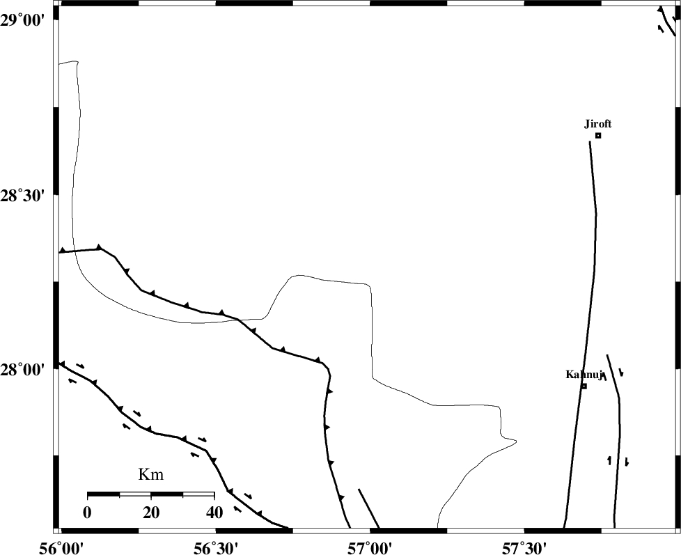
| Region | 79 km North-West of Kahnuj, Kerman Province |
Nearest Cities |
|
| 12 km East of Sarkhan, Kerman Province | |
| 34 km North West of Hurpasefid, Kerman Province | |
| 37 km North West of Faryab, Kerman Province | |
| 47 km North West of Mehrueye-e paeen, Kerman Province | |
| 48 km South of Dolatabad, Kerman Province | |
| Depth | 18 km |
| Agency | |
Faults within 150 km: |
|
| MAIN_ZAGROS_R_F (Length: 1106 km) , Distance to epicenter: 34 km | |
| ZENDAN_MINAB_F_Z1 (Length: 183 km) , Distance to epicenter: 71 km | |
| SABZEVARAN_F (Length: 190 km) , Distance to epicenter: 72 km | |
| Number of Phases | 5 |
| RMS | 0.3 |
| Number of Stations | 4 |
| Error in Latitude | >4.3 km |
| Error in Longitude | 8.4 km |
| Error in Depth | 12 km |
Download waveform in seisan format
to download seisan software Click here
to access information about IIEES stations Click here
Amplitude | ||||||||
| UID | Agency | Station | Component | Amplitude | Period | Arrival Time | Proccessing Time | Signal Clip |
| 49467 | IIEES | BNDS | N | 17059.2 | 0.64 | 2008-06-27 16:52:16 | 2009-01-18 12:56:00 | n |
| 49468 | IIEES | KRBR | N | 2915.3 | 0.28 | 2008-06-27 16:52:37 | 2009-01-18 12:56:00 | n |
| 49469 | IIEES | KRBR | E | 3333.2 | 0.76 | 2008-06-27 16:52:38 | 2009-01-18 12:56:00 | n |
| 49470 | IIEES | GHIR | E | 616.1 | 0.32 | 2008-06-27 16:53:17 | 2009-01-18 12:56:00 | n |
| 49471 | IIEES | GHIR | N | 565.8 | 0.28 | 2008-06-27 16:53:20 | 2009-01-18 12:56:00 | n |
Phase | ||||||||||||
| Agency | Station | Component | Phase Type | Phase Quality | First Motion | Observed Arrival Time | Time Residual | Loc. Flag | Input Weight | Distance | Azimuth | |
| IIEES | BNDS | Z | Pg | E | 2008-06-27 16:51:57 | 0.2 | y | 127 | 219 | |||
| IIEES | KRBR | Z | Pg | E | 2008-06-27 16:52:06 | -0.5 | y | 189 | 353 | |||
| IIEES | KRBR | N | Sg | E | 2008-06-27 16:52:30 | 0.4 | y | 189 | 353 | |||
| IIEES | GHIR | Z | Pn | E | 2008-06-27 16:52:32 | -0.1 | y | 392 | 271 | |||
| IIEES | ZHSF | Z | Pn | E | 2008-06-27 16:52:33 | 0.1 | y | 397 | 68 | |||