
Magnitude |
:3.5 |
| Date & Time (UTC) | 2008-06-16 15:53:22.7 |
| Date & Time (Local) | 1387/3/27 20:23:22.7 |
| Location | Lat:28.24 Lon: 55.79 |
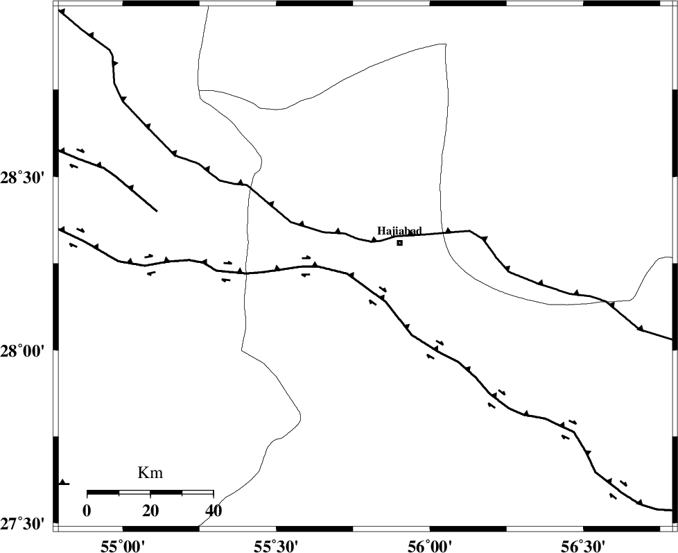
| Region | 13 km West of Hajiabad, Hormozgan Province |
Nearest Cities |
|
| 13 km West of Hajiabad, Hormozgan Province | |
| 50 km North West of Fareqan, Hormozgan Province | |
| 55 km North East of Darz, Fars Province | |
| 57 km South East of Tal bargah, Fars Province | |
| 58 km East of Doborji, Fars Province | |
| Depth | 15 km |
| Agency | |
Faults within 150 km: |
|
| HZF2 (Length: 437 km) , Distance to epicenter: 6 km | |
| MAIN_ZAGROS_R_F (Length: 1106 km) , Distance to epicenter: 8 km | |
| HZF1 (Length: 102 km) , Distance to epicenter: 69 km | |
| Number of Phases | 3 |
| RMS | 0 |
| Number of Stations | 3 |
| Error in Latitude | >1.4 km |
| Error in Longitude | 2.2 km |
| Error in Depth | 0 km |
Download waveform in seisan format
to download seisan software Click here
to access information about IIEES stations Click here
Amplitude | ||||||||
| UID | Agency | Station | Component | Amplitude | Period | Arrival Time | Proccessing Time | Signal Clip |
| 49381 | IIEES | BNDS | N | 1775.3 | 0.44 | 2008-06-16 15:54:02 | 2009-01-18 12:56:00 | n |
| 49382 | IIEES | KRBR | E | 482.9 | 0.6 | 2008-06-16 15:54:27 | 2009-01-18 12:56:00 | n |
| 49383 | IIEES | KRBR | N | 423.1 | 0.44 | 2008-06-16 15:54:28 | 2009-01-18 12:56:00 | n |
| 49384 | IIEES | GHIR | E | 183.9 | 0.4 | 2008-06-16 15:54:55 | 2009-01-18 12:56:00 | n |
| 49385 | IIEES | GHIR | N | 196.5 | 0.52 | 2008-06-16 15:55:07 | 2009-01-18 12:56:00 | n |
Phase | ||||||||||||
| Agency | Station | Component | Phase Type | Phase Quality | First Motion | Observed Arrival Time | Time Residual | Loc. Flag | Input Weight | Distance | Azimuth | |
| IIEES | BNDS | Z | Pg | E | 2008-06-16 15:53:39 | 0 | y | 101 | 158 | |||
| IIEES | KRBR | Z | Pg | E | 2008-06-16 15:53:58 | 0 | y | 215 | 26 | |||
| IIEES | GHIR | Z | Pn | E | 2008-06-16 15:54:04 | 0 | y | 275 | 272 | |||