
Magnitude |
:3.1 |
| Date & Time (UTC) | 2008-06-15 20:15:47.0 |
| Date & Time (Local) | 1387/3/27 00:45:47.0 |
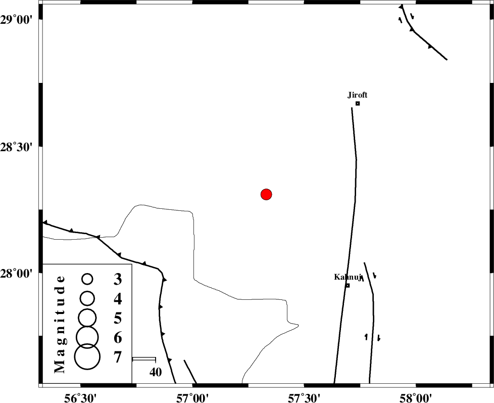
| Location | Lat:28.31 Lon: 57.33 |
| Region | 53 km North-West of Kahnuj, Kerman Province |
Nearest Cities |
|
| 13 km North of Hurpasefid, Kerman Province | |
| 24 km North West of Bolock, Kerman Province | |
| 26 km North of Mehrueye-e paeen, Kerman Province | |
| 28 km North of Faryab, Kerman Province | |
| 44 km East of Sarkhan, Kerman Province | |
| Depth | 17 km |
| Agency | |
Faults within 150 km: |
|
| SABZEVARAN_F (Length: 190 km) , Distance to epicenter: 39 km | |
| JIROFT_F (Length: 144 km) , Distance to epicenter: 52 km | |
| MAIN_ZAGROS_R_F (Length: 1106 km) , Distance to epicenter: 57 km | |
| Number of Phases | 5 |
| RMS | 0.1 |
| Number of Stations | 4 |
| Error in Latitude | >2.7 km |
| Error in Longitude | 4.1 km |
| Error in Depth | 5.9 km |
Download waveform in seisan format
to download seisan software Click here
to access information about IIEES stations Click here
Amplitude | ||||||||
| UID | Agency | Station | Component | Amplitude | Period | Arrival Time | Proccessing Time | Signal Clip |
| 49376 | IIEES | BNDS | N | 379.6 | 0.6 | 2008-06-15 20:16:32 | 2009-01-18 12:56:00 | n |
| 49377 | IIEES | KRBR | E | 145 | 0.6 | 2008-06-15 20:16:54 | 2009-01-18 12:56:00 | n |
Phase | ||||||||||||
| Agency | Station | Component | Phase Type | Phase Quality | First Motion | Observed Arrival Time | Time Residual | Loc. Flag | Input Weight | Distance | Azimuth | |
| IIEES | BNDS | Z | Pg | E | 2008-06-15 20:16:12 | -0.2 | y | 152 | 229 | |||
| IIEES | BNDS | N | Sg | E | 2008-06-15 20:16:31 | 0.2 | y | 152 | 229 | |||
| IIEES | KRBR | Z | Pg | E | 2008-06-15 20:16:19 | 0 | y | 193 | 343 | |||
| IIEES | ZHSF | Z | Pn | E | 2008-06-15 20:16:39 | 0.1 | y | 365 | 66 | |||
| IIEES | GHIR | Z | Pn | E | 2008-06-15 20:16:47 | -0.1 | y | 426 | 271 | |||