
Magnitude |
:2.6 |
| Date & Time (UTC) | 2008-06-07 02:03:37.0 |
| Date & Time (Local) | 1387/3/18 06:33:37.0 |
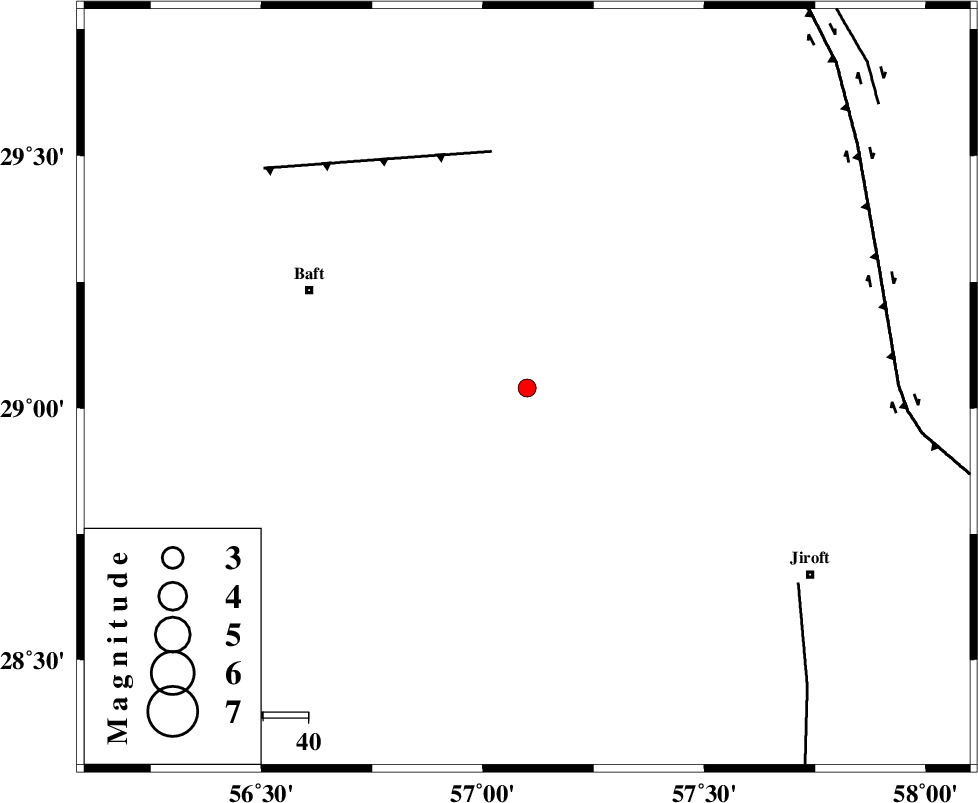
| Location | Lat:29.04 Lon: 57.1 |
| Region | 52 km South-East of Baft, Kerman Province |
Nearest Cities |
|
| 24 km North West of Eslamabad, Kerman Province | |
| 29 km South East of Kahnuj, Kerman Province | |
| 32 km South West of Hanza, Kerman Province | |
| 33 km South East of Rabar, Kerman Province | |
| 36 km North of Dolatabad, Kerman Province | |
| Depth | 37 km |
| Agency | |
Faults within 150 km: |
|
| LALEHZAR_F (Length: 52 km) , Distance to epicenter: 53 km | |
| SABZEVARAN_F (Length: 190 km) , Distance to epicenter: 74 km | |
| GOWK_F (Length: 152 km) , Distance to epicenter: 82 km | |
| Number of Phases | 5 |
| RMS | 0.1 |
| Number of Stations | 4 |
| Error in Latitude | >2.1 km |
| Error in Longitude | 4.1 km |
| Error in Depth | 4.8 km |
Download waveform in seisan format
to download seisan software Click here
to access information about IIEES stations Click here
Amplitude | ||||||||
| UID | Agency | Station | Component | Amplitude | Period | Arrival Time | Proccessing Time | Signal Clip |
| 49325 | IIEES | KRBR | E | 113.5 | 0.17 | 2008-06-07 02:04:13 | 2009-01-18 12:56:00 | n |
| 49326 | IIEES | KRBR | N | 85.8 | 0.35 | 2008-06-07 02:04:18 | 2009-01-18 12:56:00 | n |
| 49327 | IIEES | BNDS | N | 45.7 | 0.46 | 2008-06-07 02:04:46 | 2009-01-18 12:56:00 | n |
| 49328 | IIEES | GHIR | E | 20.9 | 0.32 | 2008-06-07 02:05:53 | 2009-01-18 12:56:00 | n |
Phase | ||||||||||||
| Agency | Station | Component | Phase Type | Phase Quality | First Motion | Observed Arrival Time | Time Residual | Loc. Flag | Input Weight | Distance | Azimuth | |
| IIEES | KRBR | Z | Pg | E | 2008-06-07 02:03:55 | 0 | y | 109 | 342 | |||
| IIEES | BNDS | Z | Pg | E | 2008-06-07 02:04:09 | -0.2 | y | 204 | 207 | |||
| IIEES | BNDS | N | Sg | E | 2008-06-07 02:04:34 | 0.2 | y | 204 | 207 | |||
| IIEES | ZHSF | Z | Pn | E | 2008-06-07 02:04:27 | 0 | y | 362 | 79 | |||
| IIEES | GHIR | Z | Pn | E | 2008-06-07 02:04:33 | 0 | y | 411 | 259 | |||