
Magnitude |
:3 |
| Date & Time (UTC) | 2007-01-29 14:17:48.0 |
| Date & Time (Local) | 1385/11/9 17:47:48.0 |
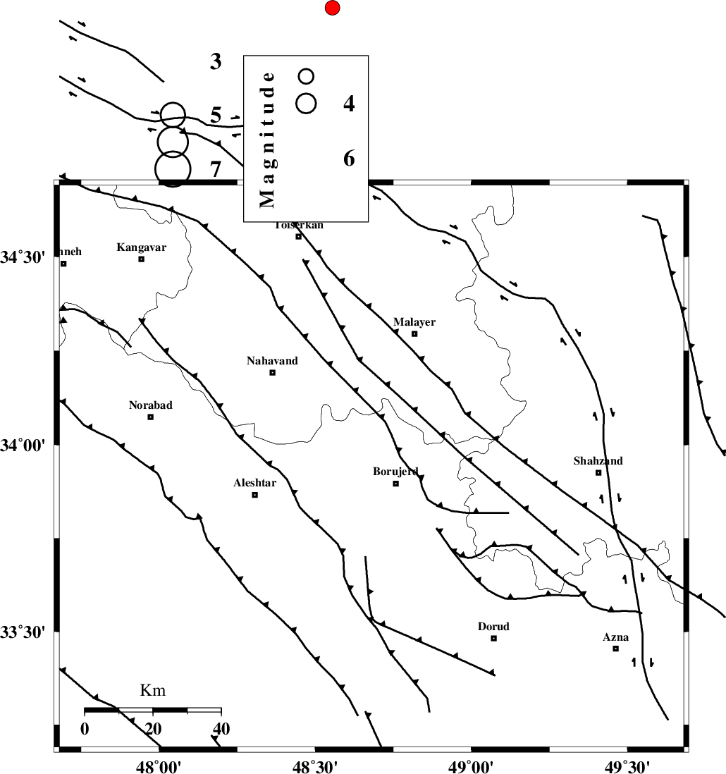
| Location | Lat:33.94 Lon: 48.68 |
| Region | 8 km Borujerd, Lorestan Province |
Nearest Cities |
|
| 3 km of Bon dizeh, Lorestan Province | |
| 9 km North of Borujerd, Lorestan Province | |
| 9 km of Ashtarinan, Lorestan Province | |
| 13 km South of Darre-ye gorg, Lorestan Province | |
| 16 km North West of Hemmatabad, Lorestan Province | |
| Depth | 14 km |
| Agency | |
Faults within 150 km: |
|
| NAHAVAND_F (Length: 102 km) , Distance to epicenter: 5 km | |
| DORUD (Length: 100 km) , Distance to epicenter: 17 km | |
| SAHANEH_F (Length: 77 km) , Distance to epicenter: 46 km | |
| Number of Phases | 5 |
| RMS | 0.2 |
| Number of Stations | 4 |
| Error in Latitude | >2.7 km |
| Error in Longitude | 2.8 km |
| Error in Depth | 7.3 km |
Download waveform in seisan format
to download seisan software Click here
to access information about IIEES stations Click here
Amplitude | ||||||||
| UID | Agency | Station | Component | Amplitude | Period | Arrival Time | Proccessing Time | Signal Clip |
| 37451 | IIEES | ASAO | N | 194.6 | 0.6 | 2007-01-29 14:18:34 | 2007-05-09 05:26:00 | n |
| 37452 | IIEES | ASAO | E | 217.6 | 0.44 | 2007-01-29 14:18:34 | 2007-05-09 05:26:00 | n |
| 37453 | IIEES | SHGR | E | 202.2 | 0.44 | 2007-01-29 14:18:50 | 2007-05-09 05:26:00 | n |
| 37454 | IIEES | SHGR | N | 146.9 | 0.52 | 2007-01-29 14:18:54 | 2007-05-09 05:26:00 | n |
Phase | ||||||||||||
| Agency | Station | Component | Phase Type | Phase Quality | First Motion | Observed Arrival Time | Time Residual | Loc. Flag | Input Weight | Distance | Azimuth | |
| IIEES | ASAO | Z | Pg | E | 2007-01-29 14:18:11 | -0.2 | y | 141 | 61 | |||
| IIEES | SNGE | Z | Pg | E | 2007-01-29 14:18:17 | 0.1 | y | 177 | 317 | |||
| IIEES | SHGR | Z | Pg | E | 2007-01-29 14:18:21 | -0.1 | y | 203 | 177 | |||
| IIEES | NASN | Z | Pn | E | 2007-01-29 14:18:46 | 0.1 | y | 404 | 107 | |||
| IIEES | NASN | N | Sg | E | 2007-01-29 14:19:41 | 0.2 | y | 404 | 107 | |||