
Magnitude |
:3 |
| Date & Time (UTC) | 2007-01-10 22:27:33.3 |
| Date & Time (Local) | 1385/10/21 01:57:33.3 |
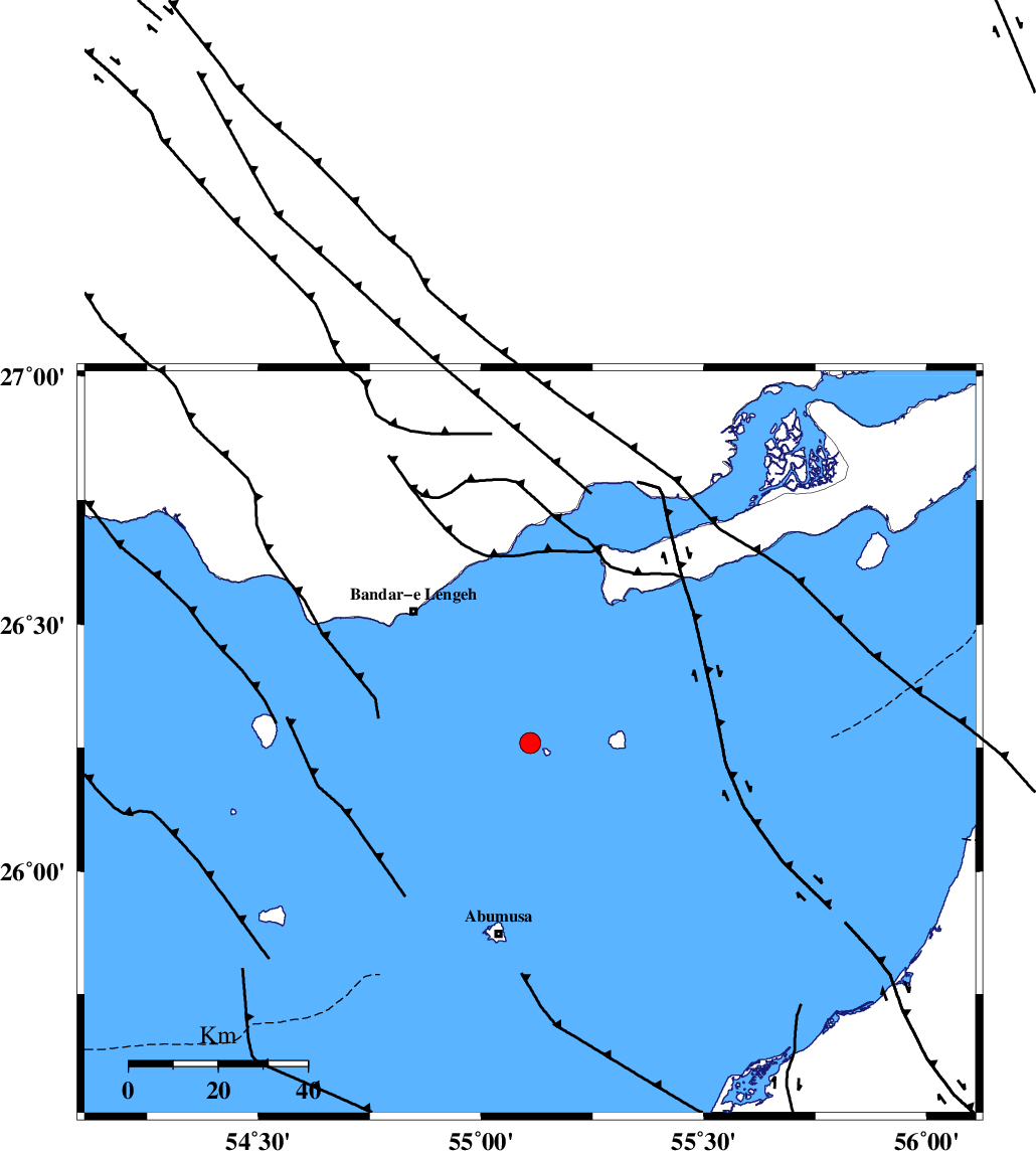
| Location | Lat:26.26 Lon: 55.11 |
| Region | Persian Gulf, 39 km South-East of Bandar-e lengeh |
Nearest Cities |
|
| 39 km South East of Bandar-e lengeh, Hormozgan Province | |
| 44 km North of Abu Musa, Hormozgan Province | |
| 90 km South West of Bandar-e khamir, Hormozgan Province | |
| 104 km North West of Sharjah, United Arab Emirates Province | |
| 110 km South West of Suza, Hormozgan Province | |
| Depth | 18 km |
| Agency | |
Faults within 150 km: |
|
| ZFF1 (Length: 165 km) , Distance to epicenter: 59 km | |
| MFF1 (Length: 180 km) , Distance to epicenter: 85 km | |
| MFF3 (Length: 292 km) , Distance to epicenter: 122 km | |
| Number of Phases | 5 |
| RMS | 0.1 |
| Number of Stations | 3 |
| Error in Latitude | >6.6 km |
| Error in Longitude | 1.9 km |
| Error in Depth | 6.6 km |
Download waveform in seisan format
to download seisan software Click here
to access information about IIEES stations Click here
Amplitude | ||||||||
| UID | Agency | Station | Component | Amplitude | Period | Arrival Time | Proccessing Time | Signal Clip |
| 37261 | IIEES | BNDS | E | 348.4 | 0.44 | 2007-01-10 22:28:24 | 2007-05-09 05:26:00 | n |
| 37262 | IIEES | BNDS | N | 408 | 0.6 | 2007-01-10 22:28:31 | 2007-05-09 05:26:00 | n |
| 37263 | IIEES | GHIR | E | 30.3 | 0.52 | 2007-01-10 22:29:13 | 2007-05-09 05:26:00 | n |
| 37264 | IIEES | KRBR | E | 14.8 | 0.92 | 2007-01-10 22:29:34 | 2007-05-09 05:26:00 | n |
| 37265 | IIEES | KRBR | N | 17.2 | 0.72 | 2007-01-10 22:29:35 | 2007-05-09 05:26:00 | n |
Phase | ||||||||||||
| Agency | Station | Component | Phase Type | Phase Quality | First Motion | Observed Arrival Time | Time Residual | Loc. Flag | Input Weight | Distance | Azimuth | |
| IIEES | BNDS | Z | Pg | E | 2007-01-10 22:28:00 | 0 | y | 164 | 40 | |||
| IIEES | BNDS | N | Sg | E | 2007-01-10 22:28:20 | 0.1 | y | 164 | 40 | |||
| IIEES | GHIR | Z | Pn | E | 2007-01-10 22:28:19 | 0.1 | y | 308 | 317 | |||
| IIEES | GHIR | E | Sg | E | 2007-01-10 22:28:59 | 0 | y | 308 | 317 | |||
| IIEES | KRBR | Z | Pn | E | 2007-01-10 22:28:35 | -0.2 | y | 443 | 21 | |||