
Magnitude |
:2.9 |
| Date & Time (UTC) | 2006-12-30 12:29:15.2 |
| Date & Time (Local) | 1385/10/9 15:59:15.2 |
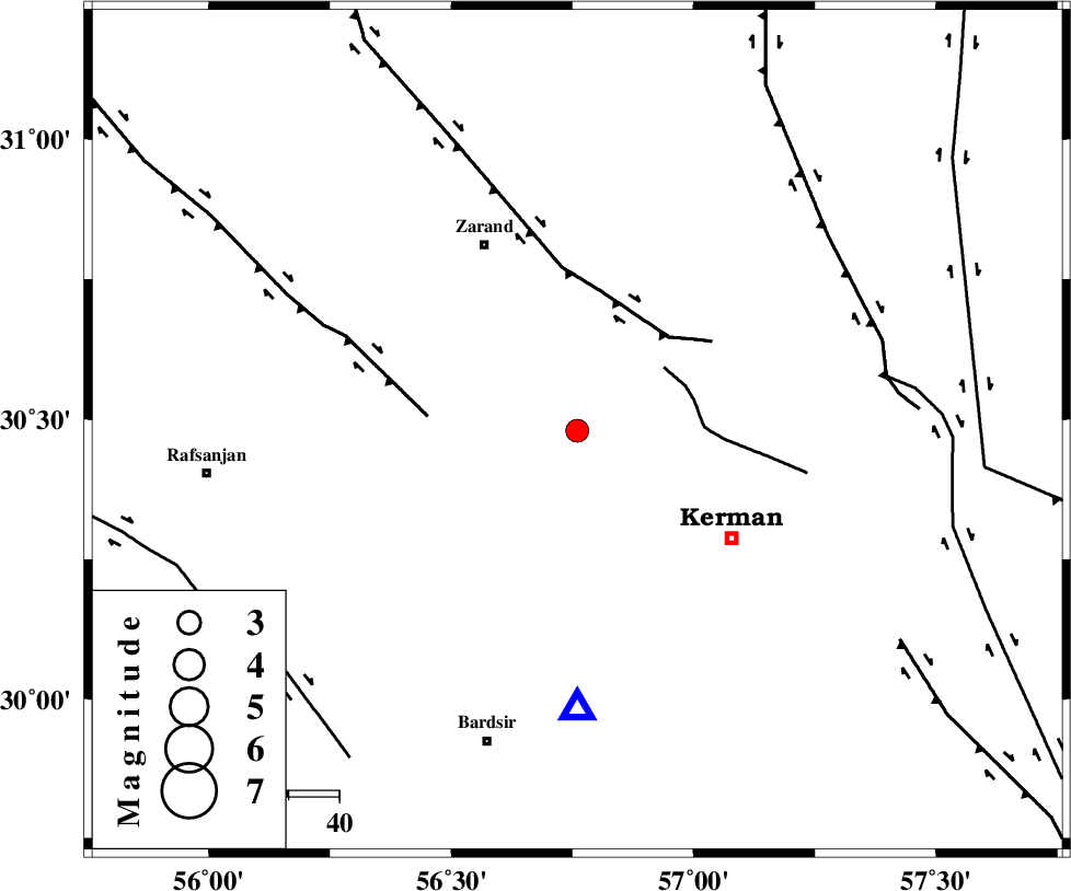
| Location | Lat:30.48 Lon: 56.76 |
| Region | 37 km North-West of Kerman, Kerman Province |
Nearest Cities |
|
| 13 km of Kazemabad, Kerman Province | |
| 16 km North West of Zangiabad, Kerman Province | |
| 20 km South West of Chatrud, Kerman Province | |
| 20 km West of Hutak, Kerman Province | |
| 23 km North West of Ekhtiyarabad, Kerman Province | |
| Depth | 25 km |
| Agency | |
Faults within 150 km: |
|
| CHATRUD_F (Length: 37 km) , Distance to epicenter: 21 km | |
| KUHBANAN_F (Length: 189 km) , Distance to epicenter: 26 km | |
| DARIVAN_F (Length: 131 km) , Distance to epicenter: 30 km | |
| Number of Phases | 6 |
| RMS | 0.3 |
| Number of Stations | 4 |
| Error in Latitude | >4.8 km |
| Error in Longitude | 6.5 km |
| Error in Depth | 7.5 km |
Download waveform in seisan format
to download seisan software Click here
to access information about IIEES stations Click here
Amplitude | ||||||||
| UID | Agency | Station | Component | Amplitude | Period | Arrival Time | Proccessing Time | Signal Clip |
| 37099 | IIEES | KRBR | N | 563.9 | 0.21 | 2006-12-30 12:29:37 | 2007-01-07 07:24:00 | n |
| 37100 | IIEES | BNDS | E | 26.7 | 0.31 | 2006-12-30 12:30:58 | 2007-01-07 07:24:00 | n |
| 37101 | IIEES | NASN | N | 24.9 | 0.47 | 2006-12-30 12:31:15 | 2007-01-07 07:24:00 | n |
Phase | ||||||||||||
| Agency | Station | Component | Phase Type | Phase Quality | First Motion | Observed Arrival Time | Time Residual | Loc. Flag | Input Weight | Distance | Azimuth | |
| IIEES | KRBR | Z | Pg | E | 2006-12-30 12:29:25 | -0.4 | y | 55.2 | 180 | |||
| IIEES | KRBR | E | Sg | E | 2006-12-30 12:29:33 | 0.3 | y | 55.2 | 180 | |||
| IIEES | BNDS | Z | Pn | E | 2006-12-30 12:30:04 | -0.2 | y | 346 | 190 | |||
| IIEES | BNDS | E | Sg | E | 2006-12-30 12:30:50 | 0.1 | y | 346 | 190 | |||
| IIEES | ZHSF | Z | Pn | E | 2006-12-30 12:30:11 | 0.1 | y | 399 | 103 | |||
| IIEES | NASN | Z | Pn | E | 2006-12-30 12:30:18 | 0.2 | y | 455 | 305 | |||