
Magnitude |
:3.3 |
| Date & Time (UTC) | 2006-12-11 00:05:05.2 |
| Date & Time (Local) | 1385/9/20 03:35:05.2 |
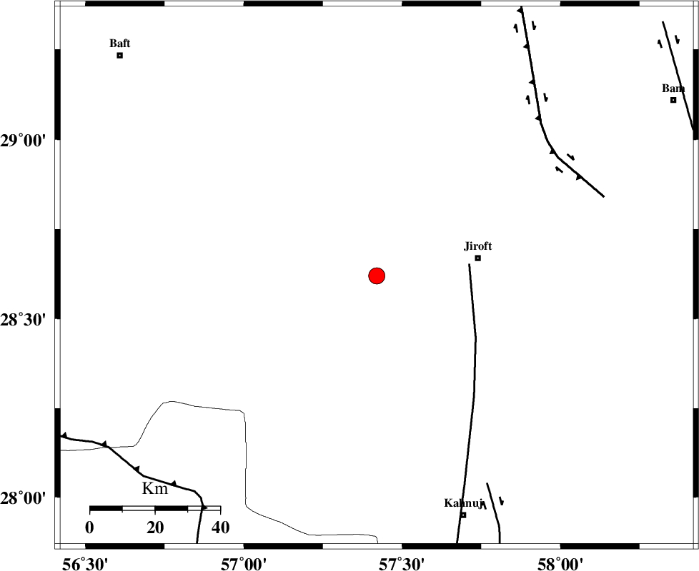
| Location | Lat:28.62 Lon: 57.42 |
| Region | 31 km West of Jiroft, Kerman Province |
Nearest Cities |
|
| 28 km North West of Khatunabad-e zangian, Kerman Province | |
| 32 km West of Jiroft, Kerman Province | |
| 35 km East of Dolatabad, Kerman Province | |
| 39 km North West of Dolatabad, Kerman Province | |
| 43 km North West of Khesrabad, Kerman Province | |
| Depth | 14 km |
| Agency | |
Faults within 150 km: |
|
| SABZEVARAN_F (Length: 190 km) , Distance to epicenter: 29 km | |
| GOWK_F (Length: 152 km) , Distance to epicenter: 67 km | |
| JIROFT_F (Length: 144 km) , Distance to epicenter: 73 km | |
| Number of Phases | 6 |
| RMS | 0.1 |
| Number of Stations | 4 |
| Error in Latitude | >1.1 km |
| Error in Longitude | 2.7 km |
| Error in Depth | 4.5 km |
Download waveform in seisan format
to download seisan software Click here
to access information about IIEES stations Click here
Amplitude | ||||||||
| UID | Agency | Station | Component | Amplitude | Period | Arrival Time | Proccessing Time | Signal Clip |
| 36921 | IIEES | KRBR | E | 297.6 | 0.16 | 2006-12-11 00:06:04 | 2007-01-07 07:24:00 | n |
| 36922 | IIEES | KRBR | N | 361 | 0.56 | 2006-12-11 00:06:04 | 2007-01-07 07:24:00 | n |
| 36923 | IIEES | BNDS | E | 468.2 | 0.4 | 2006-12-11 00:06:00 | 2007-01-07 07:24:00 | n |
| 36924 | IIEES | BNDS | N | 247.9 | 0.44 | 2006-12-11 00:06:04 | 2007-01-07 07:24:00 | n |
| 36925 | IIEES | GHIR | N | 42 | 0.44 | 2006-12-11 00:06:55 | 2007-01-07 07:24:00 | n |
| 36926 | IIEES | GHIR | E | 49.4 | 0.4 | 2006-12-11 00:06:59 | 2007-01-07 07:24:00 | n |
Phase | ||||||||||||
| Agency | Station | Component | Phase Type | Phase Quality | First Motion | Observed Arrival Time | Time Residual | Loc. Flag | Input Weight | Distance | Azimuth | |
| IIEES | KRBR | Z | Pg | E | 2006-12-11 00:05:32 | 0.1 | y | 164 | 337 | |||
| IIEES | KRBR | N | Sg | E | 2006-12-11 00:05:52 | -0.1 | y | 164 | 337 | |||
| IIEES | BNDS | Z | Pg | E | 2006-12-11 00:05:35 | -0.1 | y | 183 | 223 | |||
| IIEES | BNDS | E | Sg | E | 2006-12-11 00:05:57 | 0 | y | 183 | 223 | |||
| IIEES | ZHSF | Z | Pn | E | 2006-12-11 00:05:55 | 0 | y | 344 | 71 | |||
| IIEES | GHIR | Z | Pn | E | 2006-12-11 00:06:07 | 0.1 | y | 436 | 266 | |||